
I thought it would be many years before I got to do the Jatbula Trail. The 62km trek in Nitmiluk National Park takes you across the remote western edge of the Arnhem Land escarpment. It’s one of the most sought after hikes in the country, with a very restricted permit system which often sells out within hours of being released each year. However, I got pretty lucky.
Driving back through Katherine in the Northern Territory late in the dry season, I stopped in at Nitmiluk Visitor Centre to ask about the possibility of getting a last minute permit. Due to lockdowns across Victoria and New South Wales, there had been many cancellations and no-shows for the Jatbula in 2021. The ranger told me there was one spot leaving the next day if I wanted, so I took it.
The very next day I was up before the sun to start this epic 5-day trek across some of the most remote landscapes in the national park. This is my personal experience tackling the hot conditions of the Jatbula Trail as a solo hiker in mid-September, including a day by day look at the trail.
If you want to complete the hike yourself, I suggest you also read my guide to hiking the Jatbula Trail with all the practical information you’ll need.
Disclaimer: This post contains affiliate links which means I get a commission if you buy a product through my link at no extra cost to you. By doing so, I can keep this blog going and continue to create helpful guides for you. Read more: Privacy Policy
A bit of background on the Jatbula Trail
The trail was named after Peter Jatbula, a proud Jawoyn man who fought for land rights for his people. His family used to use a similar route across the region to connect Nitmiluk Gorge, otherwise known as Katherine Gorge, with Leliyn/Edith Falls.
The secluded path crosses waterfalls, permanent swimming holes, dry sunburnt country and past Jawoyn rock art. The one-way trek is the most popular multi-day hike in the Top End, and along with the Larapinta Trail, makes up the two most outstanding hiking experiences in the Northern Territory.
Considering the fragile environment and cultural significance, as well as, the tough climate of the Top End, the Jatbula Trail is somewhat restrictive. There’s only a maximum amount of 15 hikers leaving on the trail per day. All hikers must stay at each campsite and only for one night. And the trail is only really open from May until September each year. All of this meant that I didn’t think I would get to do it for quite a long time.
Read next: A Complete Guide to Hiking the Jatbula Trail (practical information)

Yet there I was running around Katherine, picking up some last minute supplies and packing my bag to leave the very next day on the Jatbula Trail. Sometimes, things just seem to work out.
Keep in mind that temperature are rarely below 30 during the day in Katherine, and in mid-September we had 40 degree days out on the trail. While it’s not the hardest trail to walk, the hot conditions make it an extremely challenging adventure. So, here’s my personal experience hiking the Jatbula Trail as a solo hiker.
Watch my vlog from the Jatbula Trail
Day 1: Nitmiluk Gorge to Biddlecombe Cascades
Distance: 8.5km | Time: 2.5 hours | Ascend: 175m | Descend: 75m
My alarm woke me at 5.28am in Katherine. I’d only had about 6 hours of sleep in the stifling heat and I knew this was what I was going to have to deal with for the next few days. I quickly packed the van and was on the road before the sun came up.
I was a feeling a bit anxious about the Jatbula Trail. I hadn’t handled the heat well a few weeks back on the Southern Walks in the same national park, so I was a little nervous about how I was going to get through a much more remote and longer hike. Having been up in the Top End for around six weeks though, I knew what kind of heat to expect, but also realised that hiking on top of an escarpment carrying a pack makes it a completely different adventure.
I parked my van at the Nitmiluk Visitor Centre inside the national park and walked down to the boat dock. I was told there would be at least a group of six, who had been in the safety briefing the day before at the ranger’s desk – but they weren’t there. I waited until 7.15am, and then the boat driver just said, “Let’s go – obviously no one else is coming.”

He took me across to the other side of Katherine Gorge and dropped me on the river bank. “Good luck – have fun,” he said and then turned around and went back. I looked ahead at the Jatbula Trail sign and thought, “Well, it looks like it’s just you and me for the next few days, then.”
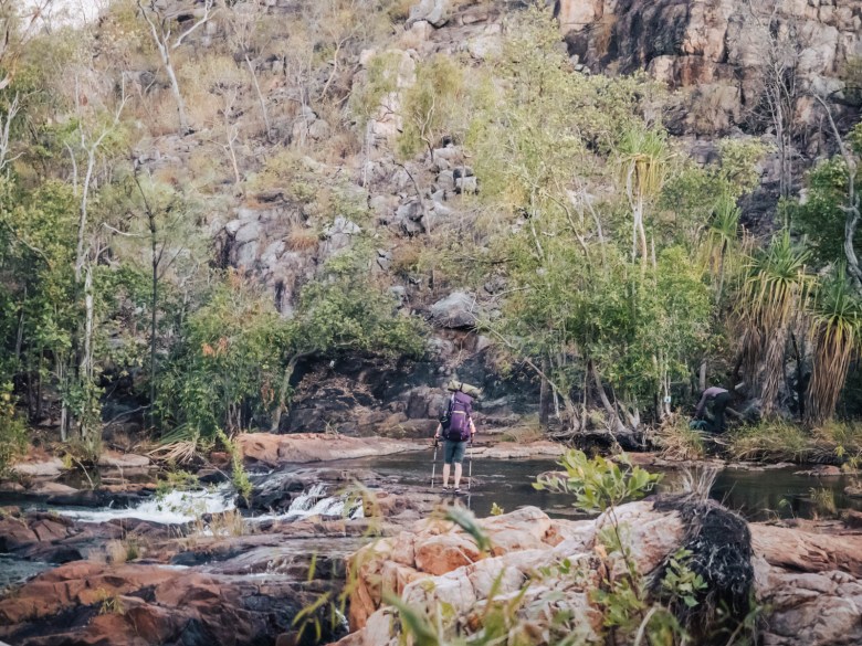
The first 3.8km was pretty easy, on a skinny but fairly flat trail to the Northern Rockhole. The incredible permanent waterhole sits at the base of towering rock walls, which has water tumbling over it in the wet season. I stopped to have a snack and then kept moving.
The last 4km were more challenging. At first, the trail followed a rocky river bed with just arrows to show the way. I had to keep my eye out though, as it left the river and headed off to the right through some scrub. It eventually met up with a service road, which was the last remaining ranger accessible point of the track until you get to Edith Falls at the end.
The road continued on a steady incline, just as the sun was starting to really bite. I stopped at the top of the hill, made myself a rehydration solution and then pushed on for the last 2km.

I sailed into the camping area which had a little shade and plenty of flat sandy ground to pitch on. I checked out the cascades just 100m away and realised it was only 10.30am – plenty of time to kill.
Two girls turned up, part of the group of six who were meant to have been on the same boat as me. The whole group had missed it as someone had left their permit behind. They all rolled in slowly over the afternoon, and then a young Dutch couple also turned up, bringing the total number of hikers on the trail to nine for the next five days.
The cascades were a series of small waterfalls and plunge pools along a deep river. There was plenty of spots to find, but one of the best ones was almost directly in front of camp. At the base of a small waterfall, the natural pool was incredible and a few of us sat in there to cool off until our skin became wrinkly.
I made my dinner at 6pm and was in bed by 7pm. The temperature had hardly dropped at all from the daily top of 39, so I slept just on top of my mattress with only the inner mesh of the tent separating me from the outside.

Day 2: Biddlecombe Cascades to Crystal Falls
Distance: 11km | Time: 3.5 hours | Ascend: 180m | Descend: 172m
I had my alarm set for 6am, but heard other people rustling at around 5. Most people were up at 5.30am but I stuck it out in my tent until my alarm sounded. The morning felt surprisingly cool, and the first four hikers were leaving at 6.30am.
I refilled my water from the river and then headed off just before 7am. There was a small creek crossing to begin with, then the trail continued on a flat path for the first couple of kilometres through grassland. By the 3km mark, the trail started crossing over bare rock and it was less obvious to follow. The large blue arrows were the only thing showing the way forward.
The trail had a slight incline for a bit and I finally found a good spot to take a break around the halfway point of the day. It then hit another hill through grassy and rocky terrain, as me and the Dutch couple kept passing each other every so often.

Finally, some views of the valley opened up to our left, but the trail started to head down again into a rocky gully. The final short hill burst for the day was a rocky climb before the trail finally descended for the last 1.5km to camp. It had been 11km of undulating terrain.
The beautiful camping spot had plenty of shade and was right next to a wide river, Crystal Creek. It was just before 10.30am so once again I had the rest of the day to chill. All afternoon, I went from napping to reading to swimming in the river. The temperature soared to around 40 degrees, after the remaining hikers stumbled in around midday.
I watched the sunset over the water from my little camping spot and was in bed by 7.30pm, ready for another early start on the Jatbula Trail as a solo hiker.

Day 3: Crystal Falls to 17 Mile Falls
Distance: 10.5km | Time: 3 hours | Ascend: 150m | Descend: 142m
I woke up at 5.30am with people well and truly up and about. I crawled from my tent at 6am to find four girls already leaving. I packed quickly and was ready to leave just after sunrise. We had to cross the big river right in front of camp where we’d been swimming the day before. Everyone had spent the previous afternoon strategising about the best way across, but I wasn’t too worried. Shoes off and just walk – you can’t avoid getting wet!
The trail then climbed up to the top of the escarpment, where there were a couple of incredible viewpoints over Crystal Falls, just as the morning sun was hitting the gorge walls. I admired it for a minute and then pressed on up the hill. The trail flattened out pretty quickly though and then remained that way for the rest of the day.
Much of the Jatbula so far had been very similar – long flat sections through grassland and woodland, with very little to show for the fact that we were actually walking right across a huge escarpment.
After 6.5km, I made it to the Amphitheatre, where I caught up to the other girls who’d left early in the morning. Just a short, steep walk off the track and down into a lush valley, an incredible Jawoyn rock art site is hidden. The green garden under the rock cave had much cooler air than where we’d been walking, so it’s no surprise that the Jawoyn people had sought some refuge from the hot sun there.

I admired the rock art and then walked back up to the trail, where everyone else had now caught up. From there, it was just 3km to camp. After a bit more mundane woodland, the landscape finally opened up to probably the best view of the whole trek.
Just off to the edge of the escarpment, you could see out to the valley floor and across to 17 Mile Falls, which was also where our camp was going to be. It was worth stopping to admire the view of this wild and pristine landscape.
Not long after and the trail crossed over a small stream and then took me to the camping area perched on top of 17 Mile Falls. It was the least impressive of all the campgrounds though. There was hardly any shade, only a few decent spots and a long climb up to the toilet.

There were a few plunge pools along the top of the huge escarpment, with much cooler water than where we’d been before. I found a spot in some shade on the rocks and relaxed for most of the afternoon. Although we all got restless with time.
A couple of the others decided to try and climb down further onto the edge of the escarpment where 17 Mile Falls plunges into the valley. Meanwhile, me and another guy just walked along the edge near camp to where we could actually see right down to the bottom of the falls.
Just at that very moment, a big crocodile swam out from the edge into the middle of the water and headed slowly towards the waterfall. While still a long way down from where we were standing, it was such a cool experience to see a wild crocodile in his completely undisturbed environment, where humans never go.
By late afternoon, some shade was finally creeping across the campground so I could set up my tent. Just before sunset though, I headed out exploring again and find a beautiful spot up on the hill to watch the changing colours of the sky.

Day 4: 17 Mile Falls to Sandy Camp Pool
Distance: 17.5km | Time: 5 hours | Ascend: 115m | Descend: 145m
The biggest day of the Jatbula Trail. I heard one girl leave at 5am, and others left at 5.30am in an effort to beat the heat. I left at sunrise as usual, with only the Dutch couple left at camp. At first the trail climbed up and over the hill behind camp, but it soon flattened out again.
I could just see the first light of the sun hitting the escarpment across to the left, but we weren’t close enough for a nice view. The trail remained to be pretty straight forward, through grass, rocks and woodland.
I passed a few of the hikers at around the 5km mark before stopping for a short break. One foot in front of the other as I continued on the skinny track, only distracted by my thoughts. After around 12km, I finally came to the Edith River Crossing. While the official map says permanent water for swimming, it was pretty dry with just some murky puddles scattered about. It was hard to believe that this very river eventually flows into Edith Falls at the end of this trek.

The crossing still had plenty of shade and large rocks, so it was perfect for a break. A bunch of hikers caught up to me and we had a nice time chatting about the day that had been. From there, it was just 5km more and it seemed to drag on forever.
The trail wound its way through tall grass and eventually thicker scrub. It was hard to follow in places, if it wasn’t for some common sense and those blue arrows. The sun rays were just starting to really kick in, and I picked up my pace for the final kilometre, just wanting to be there already.
After bashing through some leafy bush, I emerged onto the edge of some rocks with a vast billabong spread out in front of me. Paradise.
The sandy banks were for camping and I scored probably the best spot on the edge under a tree. It was just 11.30am, so I’d made good time. The Dutch girl dropped her pack and just leapt straight into the water, clothes and all. It had been a long morning.
A few trips into the deep swimming pool and an afternoon reading and napping was well spent. The incredible spot right on the billabong was probably the most incredible camp site of the trek, with the chorus of birds and frogs to fall asleep to.

Day 5: Sandy Camp Pool to Edith Falls/Leliyn
Distance: 15.5km | Time: 4.5 hours | Ascend: 73m | Descend: 162m
The final day of the Jatbula Trail as a solo hiker! Everyone was up and gone by sunrise, and even I had left at 6.30am. We were all keen for that kiosk at Edith Falls.
The trail was mostly flat through increasingly thick vegetation, unlike the dry landscape that we’d hiked through for much of the trek. The grassy trail was mostly flat again and I caught up to a couple of the other hikers, giving them the good news that we weren’t far away from Sweetwater Pool.

At the 11km mark, the trail emerged onto some rocky ground, which forms the edge of the incredible Sweetwater Pool. Much the same as Sandy Camp Pool, it’s a huge billabong with exceptionally deep water.
Sweetwater Pool is the furtherest point that day hikers can go from Edith Falls without a Jatbula Trail permit. I’d in fact been to Sweetwater when I spent a few days at Edith Falls a week before. It was a weird feeling to share a swimming spot with other people, who were pretty impressed we’d already covered 11km that morning.

From Sweetwater, it was just 4.5km to the end at Edith Falls. I knew this section well, having walked it before. It crossed over some rocky sections around the water hole and past Long Hole Pool, and then flattened out again to cross the sandy ground.
It ascended as it got closer to the Upper Falls and then the steep descent on rocky steps to get into the car park at Edith Falls. It was busy, as it always is in the dry season, but all us hikers wanted was to make a bee line for that kiosk.
After some fresh and non-dehydrated lunch at the cafe, I left my pack and walked to the huge natural pool at the base of Edith Falls. I jumped in – officially marking the end of my Jatbula Trail adventure!
I had to wait until 3pm for the transfer that takes independent hikers back to Nitmiluk Visitor Centre each day. It was a long afternoon, but I was pretty stoked, to have finished this epic trail.

Camping on the Jatbula Trail
There are five designated campgrounds on the Jatbula Trail, with the fifth one being optional. Each campground is only allowed a maximum of 15 people and you can only stay one night at each spot. Each of the campgrounds are next to a river or cascades for swimming and drinking. They all have a basic long drop toilet and an emergency call device. Otherwise, there are no other facilities and you need to carry everything you need with you.
- Biddlecombe Cacades
- Crystal Falls
- 17 Mile Falls
- Sandy Camp
- Sweetwater Pool (optional)

Trail navigation
Navigation is pretty straightforward, as there’s only one single track to follow the entire way. It’s marked with big blue arrows on a reflective white background. These are spaced well and you can usually see the next one when you’re standing next to an arrow, but this isn’t always 100% true.
There are a couple of sections that cross over a bare rocky surface which makes the trail a little invisible, but if you follow the arrows you can’t go wrong. NT Parks recommend downloading their free Jatbula Trail map on the Avenza app. This can help, but it’s not very interactive like Maps.Me, which is also free. I had both, but used Maps.Me more often.
The trail was a bit overgrown in some places too, but luckily the arrows are usually placed high up on trees. There were no snakes out and about when I did it in mid-September, but King Browns are out there. Although, apparently their numbers are pretty low now thanks to the pesky cane toads.

Jatbula Trail cost
When I did the Jatbula Trail in 2021, it was still at an extremely cheap price. I paid the $4 per night camping fee + $15 ferry crossing at the start + $75 transfer from Edith Falls back to Nitmiluk.
However, as of 2022, a new walking fee has been introduced. This is $25 per night on top of the camping fee, which would have added $100 onto my total cost. Still pretty affordable for a five day trek!
You need to book and pay for your permit in advance. They’re usually released months ahead of the season, so you need to keep you eye out. You can find more information on NT Parks website here and make any bookings here.

Jatbula Trail vs Larapinta Trail
Being the two most popular and well-known trails in the Northern Territory, the Jatbula Trail and Larapinta Trail often get compared. But, they really are two very different experiences and I don’t think it’s a fair comparison. However, I’ll just outline what makes these hikes different for anyone trying to decide between the two.
In my opinion, the Jatbula Trail is an easier walk. The 62km trail is graded moderate and is definitely not as physically demanding as the 231km long Larapinta. While both cross some pretty rocky ground, nothing can compare to the rugged terrain and relentless ascents and descents on the Larapinta Trail in Central Australia. In comparison, the Jatbula Trail has plenty of long flat sections, with minimal hills.
However, the real physical challenge on the Jatbula Trail is the heat. The consistent hot weather in Nitmiluk National Park even in the middle of the dry season, means that the Jatbula is no walk in the park. You have to look after yourself and try to avoid dehydration and heat exhaustion as best you can.
Both trails also cover very different landscapes. The Larapinta Trail is dominated by the peaks and ridge lines of the West MacDonnell Ranges and offers some of the most dramatic panoramas from the high vantage points. On the other hand, the Jatbula is not necessarily about the stunning vistas, but more about the opportunity to enjoy the natural swimming holes and cascades. The unique aspect of the Jatbula is being able to swim every day, right next to where you’re camped.
On top of all this, both are vastly different distances. The Larapinta Trail takes around two weeks to complete, whereas you’ll be finished the Jatbula in under a week. Both now require booking, but the Larapinta is much easier to secure with less restrictions on hiker numbers.
Take your pick, but I’d put both trails on your hiking bucket list if you can!
Some of my other track notes from multi-day hikes in Australia:
Hiking the Larapinta Trail End-to-End Solo: Part 1
Great Ocean Walk Track Notes as a Solo Hiker
Pin this post


[…] I’ve put together this guide for independent hikers hoping to organise their own self-guided Jatbula Trail trek. However, much of this information would also help anyone planning on doing it with an organised tour as well. Otherwise, I’ve also got my day by day track notes from the trail here. […]
This hike looks amazing! From what I can gather by your info this looks quite safe for a solo female hiker??
It’s an incredible experience! And yes, it’s definitely a great hike for a solo female, there’s always others around and it’s easy to organise yourself, once you secure a permit.
Thanks Elisha. Hubby doesn’t want me hiking solo but I think I’m ready to take the plunge. This hike interests me but some tassie hikes do too. Tassie, such as the overland,also seems quite female solo friendly. Will choose one or the other I think. Cheers!
Take the plunge! (although I’m pretty bias, obviously!) Tassie definitely has some great hikes too, I’ve got to get down there myself soon. There’s probably more options there for solo hikers, but definitely add this one to your list too!
[…] Read next: A Complete Guide to the Jatbula Trail + Track Notes from the Jatbula Trail as a Solo Hiker […]
[…] spent weeks in Katherine and explored the national park over a few different trips. From hiking the Jatbula Trail to spending a few days at Edith Falls/Leliyn, I definitely covered most of the highlights during my […]