
Known as one of the most popular and beautiful treks in Ladakh, I decided to hike the Markha Valley trek during my time in North India. The trail follows the Markha River through a beautiful valley south of Leh town.
The trail has become relatively popular in India for a number of reasons. It’s easily accessible, it’s not difficult to navigate and it’s one of the few multi-day treks in the region that can be done independently by staying in homestays.
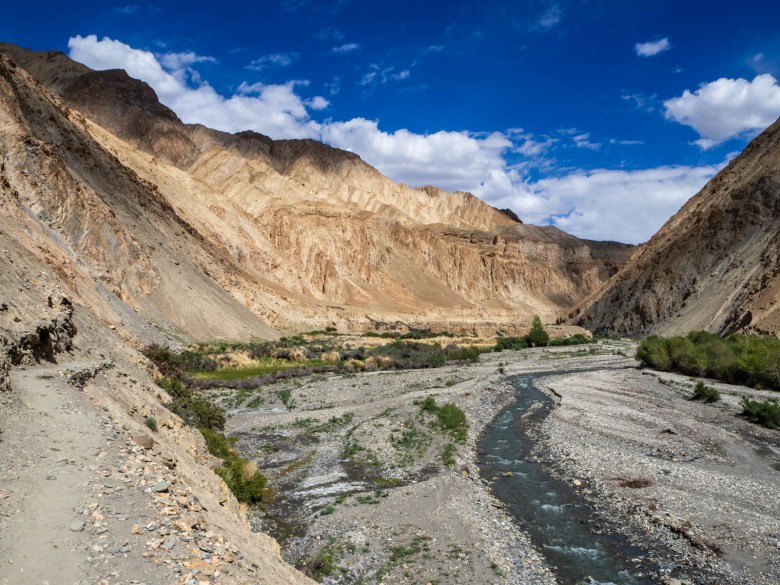
The Markha Valley trek is quite spectacular and gives you a closer view of the incredible landscapes that are found around Ladakh. The colours of the rock change every kilometre on the trail and the villages appear almost like oases along the valley floor. It was also a beautiful way to get a glimpse of the traditional Ladakhi culture and lifestyle of the region.
This guide will help any independent traveller organise and hike the Markha Valley trek in Ladakh.
Disclaimer: This post contains affiliate links which means I get a commission if you buy a product through my link at no extra cost to you. By doing so, I can keep this blog going and continue to create helpful guides for you. Read more: Privacy Policy
About the Markha Valley Trek
- Distance: 68km
- Time: 4-5 days
- Difficulty: Medium-Hard
- Highest point: Kongmaru Pass at 5250m
- Accommodation: Homestays and camping available
The Markha Valley trek follows the Markha Valley River from Chilling up to Kongmaru Pass and down to Shang Sumdo, near Hemis National Park. It passes through a beautiful arid valley that provides stark contrasts between the dry dusty slopes, snow capped peaks and green fertile villages along the river.
Throughout the valley there are small local villages living a very traditional lifestyle. The region has a long history which is evident along the way as you pass old gompas and ruins of fortresses on hilltops.
While the locals live off the land as best they can, the arrival of trekkers has brought a whole new source of income and access to supplies by mules and porters. Many of the mud-brick homes have been turned into homestays for trekkers, with each village managing the homestay program themselves. Generally speaking, each night a different house has their turn to accommodate any trekkers passing through.
This also means that the price is very consistent and each village sets a price for accommodation and food per trekker. It’s a nice change in India to know that there’s no bargaining or cheating, and you know how much you have to pay.
The Markha Valley Trek is considered the longer and more difficult hike compared to the other popular trek, the Sham Valley Trek in Ladakh.
Read next: 25 Best Things to Do in Ladakh

BUY THIS: Ottie Merino Hiking T-Shirt, Made and Owned in Australia
When to Hike the Markha Valley Trek
It’s best to tackle the Markha trek during the high season in Ladakh, between June and September. This is when the weather is at its best with clear skies, dry weather and relatively warm days. Outside of these months, you’ll likely find too much snow and some of the roads impassable.
Do You Need a Guide?
Similar to the Sham Valley Trek in Ladakh, you don’t need a guide to hike the Markha Valley trek. The trail is perfectly fine for independent hikers to follow and it’s quite common for budget travellers to complete this trek without a guide. I ended up doing most of the Markha Valley trek solo, as my two hiking buddies turned around after the first day.
However, a guide can make the experience more enjoyable if you’re not a confident hiker or you want to learn more about the local culture and history.
You can organise a guide in Leh at one of the many hiking and travel agencies in town. Prices start from around 4000 INR per day for an organised trek with a guide. Make sure you’re clear about what’s included and not included in the price, as some companies don’t include meals etc.
Any agency in Leh can also help arrange transport and porters, if you want. However, as my Markha Valley trek itinerary described below proves, you can really just head off from Leh and organise everything yourself.

Getting to the Trailhead: Chilling
With constant road construction the trailhead has moved over time. Chilling, a village on the Markha River has been traditionally considered the start of the trek. However, the dirt road now extends just past the village to a newly built bridge across the river.
When I completed the hike, I was dropped at this bridge instead of Chilling village, as it saves a couple of kilometres along a dusty, dirt road. The drive from Leh to Chilling took two hours.
The taxis in Leh have a booklet with all the official prices inside and so generally, if you’re a tourist there is not much room to bargain. The whole taxi costs around 3600 rupees (AUD$70) from Leh to the bridge/trailhead, so you can split it amongst other travellers if you find people to share it with.
Alternative Start Point
There is another option which is to start at Zingchen, which is just a short drive south of Leh. From Zingchen, you can follow the trail to Rumbak and then up to Ganda La pass at 4900m and then down to Skiu where it meets up with the Markhka Valley trek. This option adds around 2-3 days onto your hike and should only be done by those who’ve spent at least a couple of days acclimatising in Leh.
A taxi from Leh to Zingchen costs about 1900INR (AUD$38).
Read next: Best Places to Stay in Leh, Ladakh

Day 1: Chilling to Skiu
- Distance: 7 km
- Time: 2 hours
- Ascent: 180m
As we didn’t leave until midday from Leh, we decided to only hike to Skiu village (or also written, Skyu) on the first day. From the bridge where we were dropped, we followed the dirt road, which is actually now motorable until Markha although it’s not used with vehicles very much. It took us 2 hours of relatively easy walking to arrive in the village and it was already 5.30pm when we arrived.
A lady came running over from the field and said, “We have rotation system of homestay here, and it’s my turn tonight, come.” We were taken to her home where there were already two trekkers staying and we got a basic room to share with mattresses on the floor.

Day 2: Skyu to Markha village
- Distance: 21km
- Time: 6 hours
- Ascent: 420m
Unfortunately, my two friends decided to turn back as one of them had been sick overnight. Skyu is one of the last points that you can call a taxi to reach you so it was the safest decision. I then decided to keep going alone and left at 11am for the long hike to Markha village.
It was a long undulating trail through the valley floor following the river. There were chortens and stupas along the way at small passes in the trail and the colour of the mountains was insanely beautiful.
With no shelter or cover from the sun, it did get quite hot. I was sweating a lot and I ran out of water often, but I could refill at teahouses and villages along the way. I passed a few large trekking groups with donkeys, porters and guides, so I was far from alone.
I arrived in Markha at 5pm, extremely tired and dehydrated. All I wanted to do was stop and rest but I pushed on to the village to find a homestay. It took me some time but someone finally tracked down the lady who was on the roster for the night.
There was another couple also looking for a homestay and they got the only bedroom in the house, so I slept on the floor in the kitchen/dining room with the lady. We enjoyed dinner together and then I slept like a baby until 5.30am, when I heard our host get up to make breakfast.

Day 3: Markha to Lower Hankar
- Distance: 10km
- Time: 3 hours
- Ascent: 210m
I left the homestay at 8am and quickly overtook all the mule trains and trekking groups. The trail eventually wound it’s way through the valley until it came to the edge of the Markha River. There was no other choice but to wade through the freezing water which reached up to my knees.
I passed through the tiny village of Umlang where I had a ginger tea and a rest from walking at one of the teahouses.
I finally arrived in a place called Lower Hankar, which is just 1km before the main village of Hankar. A lady stopped me and said it was their turn to host trekkers. I contemplated pushing on further but wasn’t feeling the best as the elevation was getting closer to 4000m. So, I stayed the night in the large home with a few other trekkers as they rolled on through in the afternoon.
The homestay had a tent set up outside where you could enjoy the view and chat with other trekkers for the rest of the day until dinner.

Day 4: Hankar to Nimaling Camp
- Distance: 12 km
- Time: 4 hours
- Ascent: 860m
I woke up knowing I had a big day ahead of me, but I felt very positive and, sometimes that can make all the difference. I left at 8am and followed the undulating trail up to a campsite where a lot of the organised trekking groups had stayed the night before. From there, the trail was steep and so began the 800m ascent up to Nimaling.
The weather was not very good and clouds obscured the beautiful view as rain threatened to come all morning. I took a steady pace and surprised myself as to how little I had to stop to catch my breath.
The trail climbed up to the top of a ridge where I passed many of the trekking groups. Just as the rain started to fall, I finally made the last push up before the trail plateaued out for the last 2km to camp.
I was feeling pretty good, despite the day before and I made it to Nimaling in 4 hours, a time that not even the camp managers could quite believe.

The camp was at 4800m (the second highest I’d ever slept at), and the ‘homestay’ available is actually a cluster of tents that some locals manage and rent out for the season. At that altitude there are no permanent villages and only nomadic farmers who bring their stock up to fertile grounds for the summer.
I got myself my own tent and then sat in the dining room for the rest of the evening talking to people as they arrived. The rain was relentless and turned to hail and snow as the entire landscape became a blanket of white.
There was no heater in the dining tent and it was absolutely freezing once the sun set. I was okay in my down jacket that had served me well in Nepal, but many people shivered through the night. The camp was practically full, with all sorts of trekking groups and individuals. Many had guides, with just a few of us independent hikers.

Day 5: Nimaling to Kongmaru La to Shang Sumdo
- Distance: 17 km
- Time: 5.5 hours
- Ascent: 430m
- Descend: 1,580m
I woke up and anxiously peered outside the tent to see what the weather had decided to do. Luckily I could see blue skies with some cloud around, a lot better than the day before. I headed off for the pass after 8am and, like the day before, I felt very strong and was moving up the steep climb at a decent pace.
For the short 3km to Kongmaru La, it’s estimated to take around 2 hours. I made it in just over an hour, with me and a Frenchman the first two to cross the pass for the day. The view was cloudy, but still magnificent with mountains stretched out in every direction.
At 5250m, I couldn’t believe how well my body was coping. Although, staying in Leh at 3500m for a couple of weeks before had definitely helped!


I started down from the pass as soon as the snow started to fall and it was a very steep decline all the way back down to the bottom of the valley. I was going at a very quick pace, but had to make myself stop for a lunch break after such a big morning. There aren’t any teahouses along the way so it’s important to carry enough food.
As you head down through the valley, the trail can be difficult to follow. At times there seems to be numerous trails, some of which are old and have been destroyed in landslides or washed away by the raging river below.
At the time, it seemed obvious to me to simply follow the donkey poo which basically leaves a perfectly marked trail all the way back as many locals use the trail. This served me well and I never got lost. It pays to use some common sense sometimes when you don’t have a guide.
The trail does go up and down along a sheer valley and crosses the river a couple of times too. You have to be vigilant in this last part of the Markha Valley trek, as you don’t have any other way out.

Finishing the Markha Valley Trek and Getting Back to Leh
I made it to a small village called Chogdo which is the beginning of the motorable road that goes back to Leh. There were a few taxis waiting at a tea house there, but they were all pre-booked for the trekking groups. There was one who wasn’t booked and he was willing to drive me back but I wanted to wait for more people to fill the car.
I waited for two hours and then gave up, and decided to continue walking the extra 5km down to Shang Sumdo, the village at the official end of the trek and closer to the sealed main road.
I arrived and there was one tea house where a lovely old couple were sitting. The lady instantly poured me a cup of chai and I asked whether it was possible to get back to Leh.
There is a bus that leaves every Monday, but it was Saturday and I didn’t feel like waiting another whole day in the village so she called a taxi. The official rate is 2750INR (AUD$50) but we settled on 2000 rupees (AUD$40) for the return drive. It took around 90 minutes to drive back to Leh.

Accommodation on the Markha Valley Trek
The homestays were generally good, although it’s far from luxury. It’s often a mattress on the floor in a shared room with other trekkers and maybe even your host, so don’t expect too much.
You can also carry a tent and camp along the way, but the homestay experience is very much a memorable part of the trek.
The price for the accommodation was the same 1600 INR (AUD$25) each night including food. Except the Nimaling Camp sometimes charges more, about 2000 INR (AUD$31), but you have no other choice up there of any other teahouse.
There were no showers available and toilets are usually just holes in the ground. So, bring your own toilet paper!

Food
The food was very good, or at least the dinners were. Home cooked food with locally grown produce, usually rice, dahl and vegetables although they also cooked local food like stew and tingmo too.
Breakfast was only tea and some chapatti and so I never ate breakfast but had plenty of snacks with me. The homestays organise packed lunches for hikers, which were always the same; a sandwich, a boiled egg, a boiled potato or two, a juice box and a chocolate bar.
On some of the days, you’ll pass through some villages or purposely set up tents selling tea, Maggi noodles, biscuits, and other snacks. But don’t rely on this.
In regards to water, the locals drink from the river but they do offer trekkers that stay the night some filtered water.
For filtering water on a multi-day hike, I use a Sawyer Squeeze Filter because it’s small, lightweight and easy to use. For shorter hikes, I also have a Lifestraw filter bottle, which is great for day hikes and everyday travel.
Trail Navigation
The Markha Valley trek is mostly quite obvious and it would be difficult to get lost all the way through to the Kongmaru pass. There were plenty of people on the trail too, so there’s never a shortage of anyone to ask.
After the pass, however, there were a few random trails darting here and there on the way down to Chogdo, and even some trails that I could see must have been old and recently destroyed. So, its best to follow the one that has very obvious footprints and animal droppings as this will be the one that the locals use and they know best.
The trails are also marked on Maps.Me but I would actually say to follow the footprints/poo as it’s likely to be more accurate. Trails can de destroyed year to year from landslides and water.

What to Pack on Markha Valley Trek
The homestays provide almost everything you need, which means you really only need to take a small daypack with essentials. Here’s what I recommend packing:
- 30L or 45L Daypack
- Drink bottle to be refilled along the way
- Trekking poles (highly recommended for the trail up to Kongmaru La and down to Chogdo on the last day)
- Hat, sunglasses and sunscreen (the sun is incredibly strong at altitude in Ladakh)
- Trekking or walking shoes
- Headlamp for Nimaling Camp (or use your phone)
- x2 t-shirts for walking
- x1 pants, shorts or leggings for walking
- x1 long sleeve top and pants for sleeping
- x1 fleece jacket
- x1 rain jacket or poncho
- x1 down jacket (it gets very cold at Nimaling Camp)
- Underwear and x2 socks
- Toiletries (toothbrush, toothpaste, deodorant, toilet paper etc.)
- Basic first aid (BandAids or plasters, tape, Ibuprofen, electrolytes, altitude sickness pills)
- Power bank for your phone and other electronics
- Snacks from Leh
Markha Valley Trek Cost
Transport to and from: 3050 rupees (AUD$61)
Homestays & food: 6000 rupees (AUD$120)
Snacks purchased before leaving Leh: 1000 rupees (AUD$20)
There are no permits required although as I was leaving the valley I was made to pay a park fee, which was 20 rupees (AUD40c) per day.
Total: AUD$203 for five days
More Essential North India Guides
- Comprehensive Travel Guide to Ladakh
- Detailed 10 Day Leh, Ladakh Itinerary
- Complete Guide to the Sham Valley Trek in Ladakh
- Ultimate 1 Month North India Itinerary
- Best Places to Stay in Leh, Ladakh for All Budgets
- 25 Best Things to Do in Ladakh
- How to Get to Leh, Ladakh
Pin this post


Hi Elisha,
many thanks for this helpful blog post, which was very valuable for planning my Markha valley trek as an independent trekker.
I just came back from the trek and would like to share my experiences, which might be helpful for trekkers finding this page:
– As of June 2022, there are no homestays in Skiu anymore. There is a homestay in Kaya (village shortly before Skiu) and then only again at Sara (about 2-3 hours from Skiu). However, I would recommend reaching Sara on the first day anyway (see next point).
– Most of the trekkers I met followed a similar itinerary to the one proposed in this blog post (e.g., Chilling – Sara – Markha – Hankar – Nimaling – Chogdo), amounting to 5 days of trekking. However, they all told me quite frankly that they felt like wasting time, as the daily stages in the first few days are quite short and lead to killing a lot of time in the villages. To avoid this, I recommend to do the trek in 4 days, i.e., using Chilling – Sara – Hankar – Nimaling – Chogdo as stops. I personally did the trek in 3 days (Chilling – Markha – Nimaling – Shang Sumdo), but I would not recommend that unless you are very fit (i.e., do a lot of endurance training).
– In my case, there were neither a teahouse nor available taxis (not even on call) at Shang Sumdo. I asked a local to drive me the 8 kilometers to Karu (the next village at the ‘highway’) for 700 rupies. At Karu, a friendly lady then ordered a taxi for me, which took me to Leh for 1200 rupies. Alternatively, you might get a seat in the pre-booked taxis picking up the groups at Chogdo, but that may involve a lot of waiting.
– The homestay rates are still the same (1200 rupies for all homestays, 1700 at Nimaling).
Best regards,
Simon
Thank you Simon! I’m sure this will help lots of people planning this trek now. Thanks for sharing your updates with us.
Hi Simon,
Thanks a lot for your post and update on the situation on the Markha trek. I plan to do it mid of September. How long was the trek from chilling to Sara?
Can you also comment on what type of equipment you recommend to bring? Regarding drinking water did you use tablets to purify the river water?
Also from Elisha’s post I expect it’s not necessary to have a guide as there are more than enough other trekkers and it’s hard to miss the trail. Can you confirm that, also with regards to the river crossings?
Thanks a lot for your help in advance.
Stefan
Hi Simon and all, any idea if there are homestays again in Skyu? That would have been the perfect stop for a first night for me, distance wise!
i don’t believe there is a homestay in Skyu. there is a campsite within an hour though, and a homestay in Sara within 90 minutes…
Thank you, Simon! I was thinking of doing the trek in 4 days the same way you described above (Chilling-Hankar-Nimling-Shang Sumdo). I think 4 weeks is totally doable with some chill time with the locals. You validated my plan. So excited. Fingers crossed.
Hogwash- I just finished the trek and in Skiu there are 2 homestays near the monastery, there are a few about 700m from the monastery in the direction of Chilling, and there are a few about 700m down the road in the direction of Markha. Also, prices have gone up. All homestays are now 1500 Rp, and 2000 Rp at Nimaling. Also, the packed lunches are sufficient enough to not need to bring extra food with you (to save on weight).
Excellent post. Mobile network is active on Kongmaru La,. as on 1st August ’22.
Hi,
Thanks for your post Elisha & update Simon.
I plan on doing this trek late August & wondered what’s provided in the homestays? Do I need to take a sleeping bag for example or are all basics provided? I’m travelling around India from Aug 14 for 2 months and want to lug as little as possible. Thanks
Hi Richard, I didn’t take a sleeping bag, and the homestays provided blankets for the night. I’m sure you could rent a sleeping bag in Leh maybe if you wanted to, but most travellers I met just used the blankets provided. That was in 2019 though!
hiked this in August 2022. Your post is right on.
but leaves something out, IMO.
on the last day, from Kongmaru La, the descent down to Chongdo features some narrow paths with long falls if you should slip. i did just fine, but i was VERY GLAD. that the trail was dry, and also VERY GLAD that my partner wasn’t with me, as she would have freaked out. its nothing compared to many of the trails in Europe, but us Americans aren’t used to such exposed, ‘you fall, you break both legs or maybe die in the freezing river’ kind of terrain.
again, i don’t think this should stop the most confident 90% of hikers, but if i were you, i’d wait for a a clear day with dry weather for that last day if i were you.
Thank you for your comment! I agree, the last day was challenging, some trekkers got a little lost following goat tracks, you do need to be very careful and vigilant to find your way down the valley if you don’t have a guide.
Hi Riley,
Thanks for your comment. How did you navigate through the trek? Was it easy to find the right trial down on the last day?
Thanks,
Stefan
Elisha, I want to congratulate you on this and many of your other posts. They really are excellent. I’ve travelled a lot, independently wherever possible, including the Himalayas, Nepal and India, and what you’ve written is so to the point of the stuff that people need to know. What’s more, I’ve enjoyed reading it!
cheers, Jim
Thank you so much!
[…] many hikers head off on the 5-day Markha Valley Trek in Ladakh, if you’re short on time or not keen to head up to over 5000m in elevation, then […]
[…] A Guide to Hiking the Markha Valley Trek […]
Loved this post! Super helpful breakdown of the Markha Valley Trek. Felt like getting advice from a fellow trekker who’s actually been there. The day-by-day plan, homestay tips, and honest take on trail conditions are exactly what I was looking for. Makes the idea of doing it independently way less intimidating. Great job putting it all together!
Hey Elisha, I missed the dates of your hike. I am heading out solo on 25 Sept. Locals say the season has ended, so wanted to relate as I am unlikely to find too many co hikers. Thanks
Hey, I did this hike at the start of the July, which is peak season. September can be still okay, but it highly depends on the year, as sometimes the snow may have already arrived. It’s best to check at the local tourist agencies in Leh before departing. Let us know how you go! Good luck.
Hi Elisha, thank you for this great post. I am planning to do this trek independently next month, the longer version from Zinchen with a group of 6. I am most concerned about turning up at a village and there being no space left in the homestays/campsites, do you (or anyone else here!) know if this is an issue? Thank you!
Hey! I doubt it will be an issue. Even if the nominated homestay is full, they will usually just find another one to accept you. I’ve never heard of anyone being turned away from a village. However, you may just have to be flexible with sleeping arrangements, I heard someone slept on a mattress in the kitchen because the rooms were full, but this is not always the case. Hope you enjoy your trek!
Hi! Thanks for the detailed Markha Valley guide.
I’m planning to do the trek at the end of August this year. I’ll be trekking independently with one friend and we’re thinking of staying in homestays every night rather than camping.
I had a couple of questions:
1. When did you do the trek?
2. Were the homestays easy to find in Skiu, Markha, Hankar, and Nimaling, or did you pre-book them?
3. If you were doing the trek again in late August, would you still recommend the homestay-only approach?
4. Any advice for arranging a horse/mule for one backpack if needed?
Would love to hear your thoughts. Thanks!
Sure, here are the answers:
1. I did it in July a few years ago
2. I didn’t pre-book anything, as I wrote in the guide, the locals will help you find a guesthouse in each place, they have a roster system for each night so it rotates between households
3. Yes, the homestays are the best way to do the trek, except Nimaling only has tents available as there’s no village there
4. You could arrange a mule in Leh, or even one of the homestays could help along the way, but the trek is not that long and if you stay in homestays you do not need to carry much at all so I would advise just to take a small backpack and that is all