
This post is continuing on with my day by day experience as a solo female hiker on the 223km long Larapinta Trail in Central Australia.
If you haven’t already, catch up and read part one of my 15 day Larapinta Trail trek.
Disclaimer: This post contains affiliate links which means I get a commission if you buy a product through my link at no extra cost to you. By doing so, I can keep this blog going and continue to create helpful guides for you. Read more: Privacy Policy
Day 9: Ellery Creek to Serpentine Gorge
I woke up on day nine of hiking the Larapinta Trail to some ice on my tent and decided I was not getting up yet. So I sat in my sleeping bag and cooked my breakfast from inside the warmth of my tent. I saw the Trek Larapinta group walking through at 7.30am all rugged up and I waved to them from inside my -10 degree sleeping bag, “See you guys later!” (the benefits of being your own guide).
I didn’t set off until nearly 9am but over the easy terrain compared to what I’d come from I caught up to the group within an hour. “Champion! Let the champion through!”. They’d become my very own cheer squad, but please guys, don’t feed my ego.
I rolled into camp in just over 3.5 hours and thought, ‘it’s only 12.30pm again’! I contemplated moving on but thought my body could probably do with some easier days and campsites were few and far between for the next two sections. A young couple walked in and the girl said, “Oh you must be the fast walking girl with the purple backpack.” Apparently.
I had noticed the day before that my left boot had a bit of a split in the toe as if a knife had cut it but really it would have been a razor-sharp rock somewhere along the trail. It wasn’t too bad but to prevent it from getting worse I’d tried taping it over. The tape hadn’t lasted the day but I just hoped that if I kept doing it every morning it wouldn’t get any worse. The number one reason people don’t finish the trail is because of their boots falling apart and that was not going to me.
Distance: 12.5km | Time: 3 hours 40 minutes

Day 10: Serpentine Gorge to Serpentine Chalet
The next morning was a cool -6 degrees. That’s winter in the desert for you. I wasn’t cold for long though, because the trail almost immediately went upwards and switchbacked its way for a few kilometres to the top of a mountain. I was sweating even in the cool air.
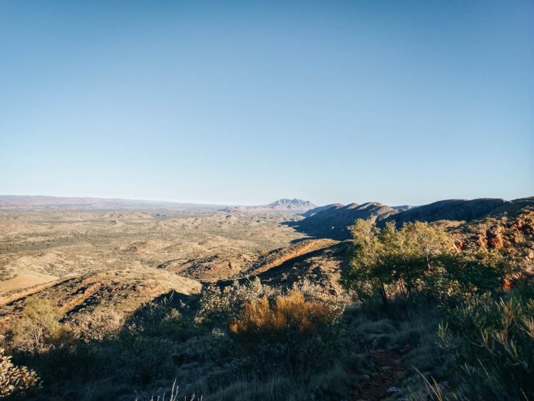
I dropped my pack and walked the extra 1.5km to Counts Point lookout, one of the best views on the whole Larapinta trail. The beautiful, parallel rock walls of the West Macdonnell Ranges appeared as though the earth’s surface was splitting open. I could also see far into the distance to Mt Sonder where I would eventually end up one of these days.
I descended down the rocky slopes to the next campsite. I was first in again meaning I got to pick a good spot, which was lucky because by nightfall there were around 10 tents pitched, a bit busy for my liking. Still, all of us hikers spent the afternoons debriefing from the day that’s been and then briefing each other for the next day to come; comparing notes, maps and guidebooks.
It was also helpful to have people coming in from the other direction to ask questions like, ‘So how steep is tomorrow’s climb really?’ and ‘What are the campsites like up on Mt Giles lookout?’. It was certainly busy but not noisy, everyone was inside their tent and torches out by 6.30pm and it was like I was the only one there.
Distance: 15km | Time: 5 hours

Day 11: Serpentine Chalet to Mt Giles Lookout
The next section was the most remote and longest of the Larapinta Trail without any guaranteed access to water, so it requires carrying enough for almost 48 hours. The section is 30km long and almost everyone breaks it up and camps somewhere along the way. I had heard early on that Mt Giles Lookout was highly underrated and definitely worth it. I wasn’t keen for a Brinkley Bluff repeat with a sleepless night of rough winds. However, after chatting to some other hikers who said there were plenty of spots further along the ridge that were quite sheltered, I thought I may as well give it a shot.
The day wasn’t too difficult, starting with another small gorge walk, some scrambling and undulating hills. The official map description had said, ‘some gentle strolling’, which we’d all had a bit of a giggle at because this is the Larapinta mate, there’s no such thing as ‘gentle strolling’. Still, it was easier than other parts.

After 13km of walking and just getting into the early afternoon sun, the trail wound up to the top of Mt Giles Lookout. According to the guidebook, it was a 330m ascent, which was nothing compared to Brinkley Bluff but for some reason, it felt much harder. They’d recently cut switchbacks into the hillside making it easier on the legs but it also meant that it lengthened the trail by a kilometre and the climb felt never-ending. It didn’t help when one guy coming down said to me, “Oh you’re almost there.” What a liar he was.
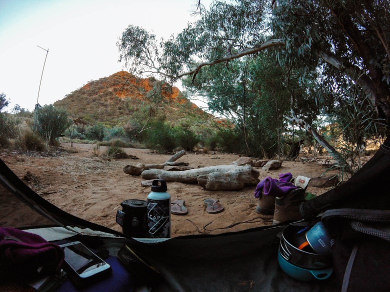
I got to the lookout, but following the recommendations by others, I continued along the ridgeline for another 1.5km where there were some really nice tent pads on a flat plateau that had plenty of trees and a high rock edge to protect you from the wind. The hill climb had been a bit of a killer and as soon as I put my tent up I found myself crawling inside and just lying down for an hour.
I inspected my left boot again, it wasn’t that much worse but I could see that the rocks were starting to chew away at other parts around the edges. There was no avoiding the rocks hiking the Larapinta Trail so I kept hoping that the tape would hold it together even if I had to keep replacing it a few times throughout the day.
It was a waiting game for dinner and I stared at my watch until it clicked over to 6pm when I boiled some water and then sat on the rocks to watch the sunset. At 11pm I woke up and could hear the roar of the wind up the side of the mountain and I thought, ‘Oh no, not again,’ but miracles do happen and the wind never hit my tent so I could sleep most of the night.
Distance: 17.4km | Time: 6 hours 15 minutes

Day 12: Mt Giles Lookout to Ormiston Gorge
Between the sunset that night and the sunrise the next day, I don’t think I’ve ever seen anything like it. The colours in the sky were so surreal with pinks, blues and oranges. As the sun rose in the morning it lit up Mt Sonder like it was telling me this is where you have to go and that’s exactly where I was heading.
I knew it was only 13km to Ormiston Gorge and it meant: my last food drop, a kiosk and a hot shower. I started walking at 8am (the earliest I’d left so far!) and I literally skidded down the slopes, jumped over all the rocks and almost broke into a jog a couple of times as I got closer. Ormiston. It promised so much.

I arrived just after 11am and I saw Zak from LTTS again. I think he was a little surprised to see me there so early. I said, ‘Mate, I practically ran here!’. He asked how I was going and I told him, “Well, I’m still smiling, aren’t I?”. I told him about my boot situation and he gave me some black gorilla tape from in his car which he said should get me through. He also handed me a couple of apples, the first fresh food I’d had in days! He was like my very own trail angel.
I wasn’t sure what was the priority; a shower or a nice meal. I chose food. I sat outside the Ormiston Cafe to eat for the sake of all the nice clean tourists inside. I was sure people could smell me from metres away; I never knew a human could smell as bad as I did. I found other Larapinta Trail hikers that I’d come to know well and I sat with them because we all smelt as bad as each other.
I watched the hot water wash away all the dirt and sweat from my body and then I washed that one t-shirt I’d worn since Alice Springs for the second time, not that I think it did much for the smell. It was getting dark and I realised I hadn’t seen the famous Ormiston Gorge yet. I asked another hiker, “How far is it? Because if it’s longer than half a kilometre it can get stuffed”. Turns out it was only 200m from the carpark, I could manage that.
Distance: 13.3km | Time: 3 hours 20 minutes
Day 13: Ormiston Gorge to Rocky Bar Gap
Refreshed and pumped to get closer to Redbank Gorge I decided to combine two days into one and push through nearly 25km to get myself to Rocky Bar Gap. I’d promised my body no more 20+ km days but I was feeling good. In fact, my body was feeling really good. It amazes me how quickly the human body can adapt when it needs to. Plus, I figured then I could relax because I’d be so close to finished.
Other hikers thought I was crazy but I knew I could do it. I also knew that I would be cursing myself by the end of the day and I was right. The first half of the day was probably the easiest of the whole Larapinta trail with just undulating, and dare I even say it, flat terrain.
Of course, that didn’t last long and I knew I had a long hill climb to the top of Hilltop Lookout with a 380m ascent. It was almost as tough as the Mt Giles Lookout climb but I knew it was the last hill before I climbed Mt Sonder at the end so once I was at the top it was easy all the way to Redbank.
I met two guys camping at the top and they were surprised that I was going to keep going down to Rocky Bar Gap but I pushed on knowing that then I would be only two days away from finishing.
Coming towards Rocky Bar Gap I clicked over the 20km mark and I was tired. Just like on day three, my brain was just thinking, ‘where is this bloody campsite?’, ‘where is this f**king campsite?’. My feet were sore and I’d had enough. I was starting to crack.
I could see people coming towards me and I thought, ‘They look clean!’ and I’m sure they thought, ‘This girl is filthy!’. They were all just starting out doing the Larapinta Trail in the opposite direction and were on day two heading up to the Hilltop for the night. Of course, I gave some of my now ‘expert advice’ on where to camp and what days were tough. It felt good because it meant I was nearly done.
I had the campsite at Rocky Bar Gap almost to myself except for one other solo female hiker who was just starting out as well and heading east to Alice Springs. She was carrying 25kg (!!!) and I gave her some advice on what to leave behind. I’m not sure if she took it on board but I’m sure she would have soon been throwing things off the side of Hilltop Lookout the next day if she didn’t!
Distance: 24.6km | Time: 7 hours
Day 14: Rocky Bar Gap to Redbank Gorge
The next day I had an easy 12km to Redbank Gorge and I walked even quicker than I had on the way to Ormiston. I arrived at the campsite at 11am. Considering I was a day early it would mean that I would camp there for two nights, so I picked a nice spot under a tree and set myself up.
I walked into Redbank Gorge to kill some time in the afternoon. Otherwise, I spend hours reading and watching birds playing in the water at the base of the water tank.
There was only a few other people camping nearby come nightfall and it was perfectly still and quiet all night.
Distance: 12km | Time: 2 hours 45 minutes

Day 15: Redbank Gorge to Mount Sonder
The next day was my final day on the Larapinta Trail. A couple of guys had left at 4am to be up Mt Sonder for sunrise but I decided that considering I had the whole day I may as well do it during daylight.
I left at 8am and headed out with just a little daypack on with some water and snacks. It felt really weird and I practically floated all the way to the top of Mt Sonder without my pack weighing me down. It was 8km to the top and it only took me just over two hours along the rocky path. The rocks. Always the rocks. I was getting pretty over the uneven ground.
As I was coming up towards the final 100m a wave of emotions hit me. I was officially finishing this epic adventure. I had endured all the challenges that it could throw at me and I came out stronger than I probably had ever been. I had pushed through a shitty first day, I had battled gale-force winds on Brinkley Bluff, I’d had an aching right foot since day six, my spare water bladder had burst on day five meaning I had been down 2L of water capacity and my left boot sole had started falling apart on day eight. Yet, there was never a doubt in my mind that I would stand on the top of Mt Sonder at the end. It was an enormous sense of achievement.
Distance: 16km round trip | Time: 3.5 hours (not including time spent at the top)

Afterthoughts: Hiking the Larapinta Trail
I was relieved. I had finished walking. I could go back to Alice Springs, have a proper shower and put some clean clothes on and eat a proper meal. But at the same time, I knew that waking up the next day would be weird because I didn’t have to walk anywhere, I didn’t have to look at maps and see how many kilometres I was going to do.
Doing any long-distance walk is a weird existence, particularly if you have no phone reception like the Larapinta Trail. It’s an existence where your entire life is simplified. You only have three things you have to do in a day; eat, sleep and walk. There’s nothing else to think about. Even decisions are simple. There’s only one trail, you have limited food and you live by the sun’s hours. The hardest and almost only decision you have to make is where to camp.
Despite being so disconnected from the outside world, it made me feel so much more reconnected with the present and with myself. I had a lot of time to spend in my own head, day after day. I met the most friendly and genuine fellow hikers of a night at the camps and everyone connected because there was no phone reception and we were all doing the same thing with the same end goal. In fact, the people I met along the way were a major part of why I had had such an incredible experience.
But I had a normal life to get back to. I wasn’t sure I was ready for that yet. Still, it was over and possibly beating Kilimanjaro as the best thing I’ve done (so far). Now how the hell am I going to top it?
Read next: Ultimate Guide to Hiking the Larapinta Trail
Pin this post


[…] Read more: Hiking the Larapinta Trail End to End Solo Part 2 […]
Hi Elisha,
I really enjoyed your diary of walking the Larapinta.
Two of my friends and I are planning to do the walk in 2023, so its great to gain an understanding of the physical and mental challenge. Which as we are all in our late 50’s, think we should it now while, we can as friends.
Thanks Brian! I hope you enjoy the trail with your friends, it’s such an incredible experience. Let me know if you have any questions!