
The Jomsom to Muktinath trek in the Mustang region of Nepal offers an incredible insight into this ancient and spiritual landscape. Jomsom has been a trekking destination in Nepal for many decades, and provides a nice jumping off point for exploring the lower Mustang region and the pilgrimage site at Muktinath.
While technically a section of the Annapurna Circuit trek, this option provides a shorter taste of what the region has to offer. After cutting my trekking in the lower Annapurna region short due to bad weather, I decided to head up to Jomsom to continue my walking.
The dry, desert-like landscape of the Tibetan plateau offered a completely different experience to the more fertile hills closer to Pokhara and you also get a nice close up view of Mount Dhaulagiri and Nilgiri, plus other Himalayan peaks.
This is my experience completing the Jomsom to Muktinath trek, including some helpful information on how to plan the trek yourself.
Disclaimer: This post contains affiliate links which means I get a commission if you buy a product through my link at no extra cost to you. By doing so, I can keep this blog going and continue to create helpful guides for you. Read more: Privacy Policy
About the Jomsom Trek
The Jomsom to Muktinath trek is a section of the much longer and well-known Annapurna Circuit. In fact, the six day itinerary detailed below from Jomsom to Muktinath and then back down to Tatopani is effectively like completing the western half of the Annapurna Circuit. This is a great option for those short on time or not looking to complete the full circuit.
While you’ll obviously be able to marvel at some of the Himalayan peaks in this region, this trek is also very much a rich cultural experience. Being able to visit the important pilgrimage sites at Kagbeni and Muktinath and staying in ancient villages of the Mustang region is extremely interesting and beautiful.
It offers an insight into the people, culture and history of the Tibetan plateau, and is a very different experience from hiking in the lower Annapurna region or Sagarmatha National Park.

What You Need to Know About Trekking From Jomsom to Muktinath
Here’s everything that you need to know about planning the Jomsom to Muktinath trek in the lower Mustang region of Nepal.
Quick Facts About the Trek
- Location: Annapurna Conservation Area
- Distance: 96km
- Time: 6 days
- Highest point: Muktinath at 3750 metres
- Difficulty: Moderate-Hard
- Start/end: Jomsom, with alternative finish further down at Tatopani
- Trail: Out and back or alternative return trail
- Permits and fees: TIMS card and park fees
- Accommodation: Teahouses
- Optional add ons: Poon Hill or the complete Annapurna Circuit trek

Best Time to Visit Jomsom
As with most other trekking regions in Nepal, the best months are considered March-April and October-November. These offer the best weather conditions for walking in the Himalayas.
However, the region is a very dry area and is located in what is referred to as the “Himalayan rain shadow”. This means that is receives much less rain and avoids the heavy monsoon that the lower Annapurna region receives over the middle of the year. You can potentially outside of the main seasons more comfortably around Jomsom, but always ask in Kathmandu or Pokhara before setting off.
Permits and Fees
You can get your Trekkers Information Management System (TIMS) card at the ACAP Office in Pokhara (near the Tourist Bus Park). It costs 2000 rupees (AUD$25).
You can also arrange the Annapurna Conservation Area park fees there for 3000 rupees (AUD$38). You have to know your rough itinerary when filling out the form and have plenty of passport photos. They also often ask for your travel insurance information as well, so have that handy with you.
Do you Need a Guide?
Yes, as of April 2023, a licensed guide is mandatory for trekking in the Annapurna Region in Nepal. This means you’ll have to hire a guide for your trek, although some people have been able to get away without one as it’s not overly enforced everywhere.
A guide can elevate your experience though, offering cultural insights and safety information. Guides generally cost about US$30 per day.
Read next: What You Need to Know About Trekking in Nepal

Gear Hire
I hired a sleeping bag from Yak and Yeti Trekking shop in Pokhara. It cost 150 rupees per day (AUD$2) for a -20deg down bag. The staff aren’t the friendliest, but they have a good reputation and the sleeping bag was one of the best I’d hired.
Similar to other trails in Nepal, I packed everything I needed into my 30L backpack, with the sleeping bag taking up half the space inside. The accessibility of teahouses means you don’t have to take too much with you.
It can be a good idea to purchase a Round Annapurna map, which covers the entire Annapurna Conservation Area. It’s especially important if you plan on changing routes or adding any side trips onto your trek. The maps go for around 350 rupees (AUD$4.50) in Pokhara.
Extending the Jomsom Trek
The Jomsom to Muktinath trek is effectively a section of the Annapurna Circuit. This means that you can extend your hike, if you want. Heading further around from Muktinath requires crossing the Thorong La, which at 5400m is no joke. However, you can easily extend the trek further south too.
The itinerary I have below is finishing at Tatopani, which is south of Jomsom. From there, you could hike up to Ghorepani and Poon Hill and then finish at Nayapul.
Note: If you want to head into the Upper Mustang region, which is north of Kagbeni, you need a special restricted permit which is US$500 for 10 days and a minimum of 2 hikers in a group.

Travelling from Pokhara to Jomsom
There are a couple of ways to get to Jomsom.
The most popular and comfortable option is to fly into Jomsom. The small airport has flights arriving and taking off only in the mornings, due to the windy conditions that always pick up in the afternoon. In high season, they offer as many flights as they can from 7am until midday. The flight time between Jomsom and Pokhara is around 30 minutes and the tickets are usually around US$125+.
However, Jomsom is also accessible by road. It’s a notoriously wild road, cut into the side of a valley following the Gandaki River, a valley some claim to be the deepest in the world if you measure from the top of the Himalayan peaks on either side.

It’s a road that was only constructed in 2008 and seems like it will be continuously under construction for decades to come. The road is a very rough, skinny mountain track that skirts the edges of steep slopes and crosses streams without bridges. It is riddled with landslides and there are machines constantly working on keeping the road open (which is impossible in the monsoon and is often closed during that time).
A bus leaves from Lakeside Pokhara at 7am. I hadn’t booked a ticket and yet I managed to score the front window seat by just getting to the office at 6.30am. It costs around 1100 rupees or AUD$14. I was told it would take anywhere between 8-12 hours and it ended up taking 11 in total for the 170km journey. They make a few stops along the way for tea and lunch.
It was a bone rattling, dusty experience that was not for the faint hearted. However, the views of course were amazing, particularly as we got closer to Jomsom.

Jomsom: Ultimate Mountain Town
Jomsom is a sprawling town in the valley floor, surrounded by Himalayan peaks. The town is now divided into New and Old. New Jomsom is what you come across first as you drive up from Pokhara. The main street is lined with hotels and restaurants, and is closer to the airport.
However, the bus dropped us in Old Jomsom, which is past the newer part. Old Jomsom is now much less commercialised, with old guesthouses that see far fewer people these days. I chose to stay there and found Hotel New Galaxy for 600 rupees (AU$7) per night.
On my way back through Jomsom, I decided to stay in New Jomsom. The guesthouses are much more expensive and hotel-like. I stayed at Himalayan Inn for 1000 rupees or AUD$12, which included a private room and my own bathroom.

Trek Report: Jomsom to Muktinath Trek
Keep reading for my Jomsom to Muktinath trek itinerary and my day by day experience on the trail.
Day 1: Jomsom to Kagbeni
Distance: 9km Time: 2.5 hours Ascended: 110m
The trail from Jomsom up to Kagbeni followed the newly built dirt road. Jeeps, motorbikes and buses flew past me and it felt like my lungs were drowning in dust most of the day.
Road construction was still going on and is likely going to be a project to last many years. If you’re hiking to Muktinath from Jomsom, it’s a good idea to be vigilant of the traffic and construction going on, as it can be potentially dangerous for all parties to share the same road.
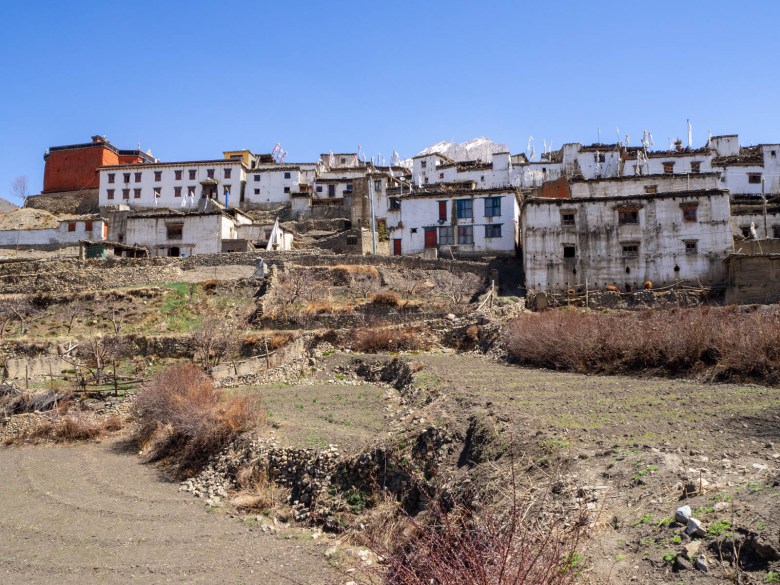
I arrived in the small town of Kagbeni, almost appearing like an oasis in the dry desert surrounding it. Being a popular pilgrimage route, many of the lodges can be full and overpriced. I managed to find a room at a place called, YakDonalds. They charged 1000 rupees (AUD$12) for a room, which is a lot more than teahouses in other areas, but it was more like a nice hotel than a trekking lodge. It has a very fancy menu as well, with yak burgers and wine, and is popular with Western tourists.
It’s worth wandering around Kagbeni in the afternoon. It’s home to a centuries old monastery and incredible old architecture which is a very beautiful introduction to the ancient Mustang region.

Day 2: Kagbeni to Muktinath
Distance: 10km Time: 3.5 hours Ascended: 840m
The trail to Muktinath continued to follow the main road which is now sealed with tarmac. Muktinath is one of the most sacred Hindu and Buddhist sites in Nepal and funding had allowed for the road to be constructed to allow easier road travel for pilgrims.
It was a steep climb leaving Kagbeni and I found little goat tracks that cut off the hairpin bends along the way. After 1.5 hours, however, the road flattened out as Muktinath came into view in the distance.
I lost count of the amount of buses and jeeps that passed me, it seemed like hundreds and I couldn’t believe how popular such a remote place was. The beautiful contrast of the brown desert and snow capped peaks in the valley were somehow dampened by the constant sound of vehicles and loud horns.
I arrived at a small, medieval town of Jharkot and decided to walk around to explore. It seemed ancient, with mud brick buildings painted in white. It was pure bliss, with just the quiet sound of my feet away from the road at last.
I continued on towards Ranipauwa, the name of the town at Muktinath. During the final steep climb up to town I caught up with a sadhu pilgrim, on his way to the temple. He spoke little English but said he had also walked from Jomsom, so I gave him a small donation for food as he allowed me to take his photo.
Sadhus rely heavily on donations for food and shelter and Muktinath is known to have pilgrims walking for days and even weeks to get to the temple.

The bus park in Muktinath was congested with all the vehicles that had been passing me and I realised that it really was hundreds of buses. People were streaming through the small town, some on foot and others on horseback as the sudden gain in altitude affected many who came by bus.
I found a highly recommended trekkers lodge called Bob Marley Hotel where the room was free and the dining room packed full of trekkers who had just come over the Thorong La Pass on the Annapurna Circuit.
The temple complex at Muktinath is the appeal of visiting this far flung place. However, it can be rather disappointing for a non-Hindu or Buddhist. It’s just a small series of temples, a ghat and a large Buddha statue. But seeing the pilgrims struggling up to 3700m in the belief that it will bring salvation is still a special cultural experience, worth all the effort.

Day 3: Muktinath to Jomsom via Lubra
Distance: 19km Time: 6.5 hours Ascended: 200m Descended: 940m
To get back to Jomsom from Muktinath, you can either follow the same road back down via Kagbeni or take the alternative route via Lubra. I decided to opt for the latter to avoid the roads completely despite the option being much more challenging.
I walked through the bus park in Ranipauwa and followed the trail on the Maps.me app, as there were no signs indicating which trail to take. The trail climbed up steeply, reaching to 3900m at the top of the small pass. The views were incredible and I had a 360 degree panorama of the Mustang region from the Thorong La Pass to Upper Mustang and to Mt Dhaulagiri back towards Jomsom.
From there, the trail skirted around the mountain, even a stretch that was through some snow. Then, it was a steep, rocky descent all the way down to the small, secluded village of Lubra, thought to be the last remaining place where the ancient Bon religion is practiced.
I stopped for lunch at Musk Deer Restaurant, where the lady made me traditional buckwheat bread with veg curry along with local seabuckthorn juice. It was delicious.
From Lubra, the lady told me there were two options to get back to Jomsom. The proper trail went up and along the valley slope on a skinny goat track, or I could just walk back through the dry riverbed and link up with the road. I took the former option even though she recommended the latter and I soon figured out why.

The skinny, rocky trail undulated along the side of the valley. At first, I thought I had made a good choice as the views were much better and I wasn’t walking down in a riverbed. However, as I came close to meeting back up with the road to Jomsom, the wind became so strong I could hardly stay upright. There had been blue and white markers consistently, however, they completely disappeared and it seemed the trail had just stopped.
I could hardly see anything with the wind and dust blowing into my face, but I could see that the road was just a steep 100m drop below me. How do I get down there? I backtracked along the edge of the cliff and saw that it became less steep, so I found a section where I could slowly scramble my way down.
I was relieved to be back on the road to Jomsom but it didn’t take long for the relief to be replaced with frustration as I continued to battle the gale force winds. The buses and jeeps all returning from Muktinath made the dust storm worse and I had my buff around my face.
By the time I got back to Jomsom, I was exhausted and covered in dust. I walked into the new part of Jomsom and scored a room with a bathroom, so I could at least have a shower!

Day 4: Jomsom to Marpha via Thini and Dhumba Lake
Distance: 10km Time: 3 hours Descended: 80m
I only had a short day ahead of me, which was a relief. The wind was still kicking around and even the flights leaving Jomsom were all cancelled (which happens often!). I decided to walk to Marpha via the route through Thini, a small traditional village, and Dhumba Lake. This meant that I mostly avoided the road.
Just half an hour from Jomsom, the small beautiful village of Thini was my favourite of the villages I would pass on the way down to Tatopani. It was so peaceful and picturesque and I would have preferred to have spent the night in the community guesthouse there instead of Jomsom, if the day before hadn’t ended in a dust storm.

From Thini I continued to Dhumba Lake, at the base of Nilgiri, with an emerald green colour. I wasn’t certain if there was a way to Marpha from the lake, however, a local man assured me there was by following the dirt road down. At the bottom, the road met two bridges across the fast-flowing river to get me to the other side of the valley.
I arrived in Marpha at 12pm, another beautiful village that is often described as a trekkers favourite. The cobbled stone streets were pretty, however, perhaps its best feature is the absence of vehicles as the road was built around rather than through the village.
I picked a lodge called Dhaulagiri Guesthouse, a lovely family run place. I had lunch and decided to rest for the day, as the winds were still strong and I’d had enough of the road for the day already.

Day 5: Marpha to Kokhethanti
Distance: 17km Time: 6 hours Ascended: 270m Descended: 270m
From Marpha onwards, trekkers are given two options since the road construction in 2008. You can either follow the road or take the new trail that goes up and down along the valley slopes. Without a doubt I decided to take the trail, although a lot of the trekkers on the Annapurna Circuit opt for the road because it’s much flatter and more direct.
From Marpha, the trail headed up to a village called Chimrang. It then went down through forest before heading back up again to another cluster of houses before descending again to a village called Sauru. The undulations had been pretty tough on the legs and I decided to stop for lunch early.
From Sauru, the trail practically skirted along the folds of the valley beside the river and was much easier. However, dark clouds rolled in not long after I’d eaten and soon it was pouring with rain. For the last 5km, the rain didn’t let up and as soon as I came into Kokhethanti, a cluster of 10 houses and one lodge, I’d already made the decision to stop for the day.
Once the rain stopped in the evening, however, the view of the icefall of Dhaulagiri was pretty amazing and worth stopping earlier than planned.

Day 6: Kokhethanti to Tatopani via Titi Lake
Distance: 30km Time: 8.5 hours Ascended: 230m Descended: 1360m
Not far from Kokhethanti, the trail again offers two options. You can go straight ahead and meet up with the main road again or turn left and head up to Titi Lake. I considered it for a minute, as my legs were starting to tire and I wasn’t sure if I wanted to climb anymore. However, I found myself veering left and making my way to Titi without overthinking.
After one hour of climbing in the crisp morning air I arrived at Titi Lake, which was nothing special in itself. However, the view of Dhaulagiri peak, the seventh highest mountain in the world, was something else. It towered above the village, extremely close and in the clear sky I would have easily been able to see someone climbing to the summit if they were.

From there, I kept going to a village called Konjo, again mostly following the Maps.me app on my phone, as the signs were few and far between. The trail then wound away from the mountains and down to a village called Choyo from where I had no choice but to meet back up with the main road via a suspension bridge.
The road was relatively quiet and hardly any vehicles passed me. It was practically all down hill and I maintained a good pace. I couldn’t believe that it was the very road that I’d come up in a bus, it really is hard to believe vehicles ply along the rocky mountain road. There were countless landslides I passed that had been cleared, a sign that the road will never really be completely safe.
I arrived in Ghasa at 12pm and found a lodge to eat some lunch before continuing on. From Ghasa, there was an option to cross to the other side of the valley and follow a goat trail through more villages. I decided to take it and was so glad that I did, as I was able to watch the buses coming up the treacherous road safely from the other side. The white capped mountains suddenly vanished behind me and the scenery changed back to green terraces.

I descended steeply down to the river again and crossed to a town called Dana. I had previously thought I would stay the night there in one of the three lodges available, however, it was 3.30pm and there was only 6km left to Tatopani so I decided to push on.
Similarly to the ending of the Langtang Valley trek, I soon realised that my legs were much more tired than I’d thought. I saw dark clouds coming overhead and the last thing I wanted was to get stuck in rain, so I kept my pace up. I covered the last 6km in exactly one hour, beating the rain and absolutely destroying my legs and feet in the process.
I stumbled into Tatopani after covering 30km for the day, and walked straight into Hotel Himalaya without any energy to scope out other guesthouses. But it meant my Jomsom to Muktinath trek was complete!

Getting Back to Pokhara
From Tatopani, the original Annapurna Circuit takes trekkers up to Ghorepani and Poon Hill before going back to Pokhara. However, considering I’d already trekked through Ghorepani on the way to Khopra Ridge, I decided my trek was complete and my time in the Annapurna region was over.
In Tatopani, there is a ‘bus park‘ just down below from the village with a booking counter. A direct bus to Pokhara leaves at 8am and it’s best to be there before 7.30am to get a ticket. The bumpy ride took around 6-7 hours, as it stopped to pick up and drop off locals along the way.
If you miss this bus, there is also the option to take one of the jeeps or buses which come through frequently to Besi, where it’s possible to change to a bus for Pokhara.

Jomsom to Muktinath Trek Accommodation
Most of the accommodation was standard teahouse trekking type-rooms, with a basic bed and shared bathroom. However, in places like Kagbeni and Jomsom, you had much nicer options, with many lodges appearing more like a hotel.
This means though that prices are a little on the steep side compared to other regions. You will likely spend a bit more on accommodation on this trek as opposed to Khopra Ridge or Langtang Valley for example.
Food
Food is slightly different than on other treks as well. The standard trekking meals of fried rice, chow mien, pasta and fried potatoes were widely available, however, there was also a wide variety of other meals on offer which was quite exciting.
Buckwheat is grown in the area and so places offered buckwheat pancakes for breakfast, an absolute gem for gluten tree travellers like myself. A couple of the smaller villages along the way also had buckwheat bread.
Apple pie, is probably the most famous food item on the Annapurna Circuit and apple trees can be seen everywhere along the way. Apple is on every menu in various forms, even apple and cinnamon tea.
There are also many more western options like pizza, burritos, even risotto, particularly in Kagbeni, Jomsom and Muktinath.

Trail Navigation
As the trail followed the Annapurna Circuit, it is pretty well marked with painted markings in sections as well as signposts and maps at major towns.
While I didn’t need my paper map, Maps.me came in handy many times on the trail from Jomsom to Tatopani, especially as I tried to avoid the road as much as possible. Some of the turnoffs to alternative trails were hard to find if you weren’t looking for them.
Cost of Jomsom to Muktinath trek
Permit and park fees: 5000 rupees or AUD$65
Transport (to and from): 1700 rupees or AUD$22
Snacks: 1350 rupees or AUD$17
Sleeping bag rental: 1200 rupees or AUD$15
Meals and accommodation: 14,000 rupees or AUD$180
Total: AUD$299 for seven nights, eight days
More Trekking Guides for Nepal
- Khopra Ridge: How to Complete the Khopra Ridge Trek
- Gokyo Lakes: How to Complete the Gokyo Lakes Trek from Salleri
- Langtang Valley: A Guide to the Langtang Valley Trek
- Trekking Tips: 10 Essential Tips for Trekking in Nepal
- Responsible Travel: Responsible Travel Guide to Nepal
Pin this post


What an amazing article, thank you so much.
What an amazing article, thank you so much.
https://www.nepalnomad.com/blog/thamel
Amazing article and photographs, thank you
I love how this article offers a deep cultural experience alongside stunning Himalayan views, all without needing to commit to the full Annapurna Circuit. Thanks for capturing that feeling so well in your post
excellent and helpful
The article on the Jomsom to Muktinath trek is a great read! It gives a clear picture of the trail, from the stunning mountain views to the spiritual vibes of Muktinath. The details on route highlights and travel tips make it super helpful for trekkers planning the journey. A concise yet informative guide for anyone curious about this classic Himalayan adventure.
Loved how this guide highlights both the landscapes and the culture of Lower Mustang. Very inspiring read!
what a amazing article love it !!
thank you so much