
Before I’d arrived in Nepal, the research that I had done on different hikes led me to the Khopra Ridge trek in the Annapurna region. For me, it seemed to tick all the right boxes: it was less popular, less commercialised, supported local communities and offered some of the best views in the region.
Soon after finishing my first trek in Nepal in Langtang Valley, my thoughts immediately turned to Khopra Ridge.
Khopra Ridge begins in Nayapul, the same starting point as the ever popular Annapurna Base Camp (ABC) trek. Instead, it climbs up to Khopra Danda, a single community lodge perched right on the edge of a ridge with exceptional views of two of the highest mountains in the world.
It’s a great alternative trail if you want to escape the crowds and is definitely an underrated trek in Nepal. Keep reading for my guide to the Khopra Ridge trek, including my day by day experience on the trail.
Disclaimer: This post contains affiliate links which means I get a commission if you buy a product through my link at no extra cost to you. By doing so, I can keep this blog going and continue to create helpful guides for you. Read more: Privacy Policy
About the Khopra Ridge Trek
For some context, it’s worth knowing a bit more about how the trail came about.
The trek is part of the Annapurna Dhaulagiri Community trek, a brain child of Mahabir Pun, known as ‘the man who brought internet to rural Nepal’. Mahabir is a local to the area who, after contacting the BBC in 2001, managed to begin a project with the help of international donors to establish high speed wireless internet connection to many of the villages on the trek.
Since then he has also worked on sustainable livelihood projects, one of which was to establish a community trek. The idea behind this trail was that trekking lodges would be community-run with all money going back into local schools and health clinics.
Mahabir also has a restaurant in Thamel, Kathmandu called Mahabir Dai’s restaurant, which operates as a not-for-profit and I visited it for lunch before leaving for Pokhara. They have maps and information there for those interested in supporting his projects or doing the whole community trek (Khopra Ridge is just a section of it).
What You Need to Know About the Khopra Ridge Trek
If you’re planning to hike Khopra Danda in Nepal then here’s some essential information for you.
Quick Info About the Trek
- Location: Annapurna Conservation Area
- Distance: 60km
- Time: 6-7 days
- Highest point: Khopra Ridge 3600m or Khayer Lake at 4600m
- Difficulty: Moderate-Hard
- Start/end: Nayapul/Ghandruk or alternative finish at Tatopani
- Trail: Out and back same way or alternative return trails available
- Permits and fees: TIMS card and park fees
- Accommodation: Teahouses
- Optional add ons: Poon Hill and Annapurna Base Camp
Best Time to Hike Khopra Ridge
There are two main trekking seasons in Nepal: March-April and October-November. These are by far the best months in terms of weather and avoids the wet season in the middle of the year. The dry winter can make for quieter trails, but many teahouses close down and the trail may be impassable.
If you’re travelling at the start of the trekking seasons, it’s a good idea to ask in Kathmandu about trail conditions before you set off. When I did the trek at the end of March, some of the Annapurna area like around Annapurna Base Camp had seen increased avalanche risk, so you may need to change your trekking itinerary accordingly.

Permits and Fees
It took just a day to organise everything for the trek in Pokhara. I walked the 2km to the ACAP Office (near the Tourist Bus Park) where I got my Trekkers Information Management System (TIMS) card for 2000 rupees (AUD$25).
I also arranged my Annapurna Conservation Area park fees there for 3000 rupees (AUD$38). You have to know your rough itinerary, have plenty of passport photos and have your travel insurance information with you.
Do You Need a Guide?
As of 2023, it’s compulsory for foreigners to have a guide while trekking in Nepal. However, this has only been enforced sparingly, and some have got away with not having a guide.
Guides do offer fantastic knowledge and up to date safety information for the trail, so they can be worth employing. It costs around US$30 per day for a guide.
Gear Hire
I hired a sleeping bag from Yak and Yeti Trekking shop in Pokhara. I paid 150 rupees per day (AUD$2) for a -20deg down bag. The staff weren’t the friendliest, but they have a good reputation and the sleeping bag was fantastic (possibly too warm!) so I can’t complain.
Similar to Langtang Valley, I packed everything I needed into my 30L backpack again, with the sleeping bag taking up half the space inside. Staying in teahouses means you don’t have to take too much with you.
I purchased a Round Annapurna map, which covered the entire Annapurna Conservation Area, rather than just the section I was doing. I already had plans for more trekking in the area so I knew I would need it again and due to the unpredictable weather at the time I thought my plans might change part of the way and I wanted to have a map with all of the trail possibilities. The maps go for around 350 rupees (AUD$4.50) anywhere in Pokhara.
Read next: 10 Essential Tips for Trekking in Nepal

Khopra Ridge Trek Variations
The beauty of this part of the Annapurna region is that there are a few trails that cross over so that you can tailor your own trek. The Khopra Ridge trek traditionally begins in Nayapul and heads up to Khopra Danda via Ghorepani. From Ghorepani, there’s the option to do the very popular short hike up to Poon Hill.
On the return from Khopra Ridge, you can either return the same way. Or, you can take an alternative trail back via Dobato and Tadapani, finishing in Ghandruk, which almost forms a complete loop. This is what I did and I would highly recommend it as you get the chance to enjoy the much less visited Muldai Viewpoint near Dobato.
There is also another alternative, which is only really a good idea if you’re short on time. From Khopra Ridge there is actually a steep trail straight down to Tatopani, which is technically on the Annapurna Cicuit Trek. From Tatopani, it’s possible to catch a bus back to Pokhara.
Extending the Khopra Ridge Trek
If you want to extend your trek, you can join the Khopra Ridge Trek with Annapurna Base Camp (ABC). From Tadapani or Ghandruk, you can then head along the ABC trek or even further across onto the Mardi Himal Trek.
I was originally going to do this, but the avalanche risk in the ABC area was high at the time and locals in Ghandruk warned me against it so I headed back to Pokhara instead. Always ask around for the latest information. Guides and porters on the trails are always a good source of information.

Pokhara: Base for Exploring the Annapurna Region
Pokhara is the main base from which to head off on any treks in the Annapurna Conservation Area. The city is around 200km north west of Kathmandu.
Pokhara is Nepal’s hippie haven where backpackers get lost for days or even weeks wandering by the lakeside and eating at one of the many cafes along the 4km strip of tourist shops. Lakeside is practically just a more laidback version of Thamel, with similar bars, souvenir and clothing shops and trekking gear rentals and agencies.
It has some incredible restaurants and I spent most of my time eating my way down the street. Still, after a few days, I was keen to leave Pokhara behind and head into the mountains, which were just visible from Lakeside on a clear morning.
You can easily reach Pokhara by bus from Kathmandu. The Kathmandu to Pokhara tourist buses leave every morning at 7am just outside of Thamel. They all line up along the main road, numbering up to 30 in high season. Tickets can be purchased the day before from any hostel or tour agency. The trip takes around 8 hours.
Where to Stay in Pokhara
Gaurishankar Backpackers | This was one of the nicest hostels I stayed at in South Asia. For around 500 rupees ($6) I stayed in a 4-bed dormitory. It also has a really pretty garden to chill in and the staff were so friendly. Check availability here.
Hotel Silver Oaks Inn | If you’ve got a bit more cash, then this hotel is one of the most popular mid-range options. Just back from the Main Street on Lake side, it has double and family rooms available. Check availability here.

Getting to Nayapul
The starting point, Nayapul, is not too far away from Pokhara. Being the main trailhead for many trails, including the popular Annapurna Base Camp, there are frequent public buses and jeeps plying the route.
You don’t need to pre-book a ticket, buses leave from Baglung Bus Park in Pokhara. Allow around two hours for the trip, with numerous stops and a very windy road.
Trek Report: Khopra Ridge
If you’re planning to do the trek to Khopra Ridge, below is my day by day experience on the trail if you want to read a bit more about what it’s like out in the Himalayas.

Day 1: Nayapul to Tirkhedhanga
Distance: 9km Time: 2.5 hours Ascended: 500m
I didn’t leave Pokhara until around 10am and managed to jump on a bus to Nayapul just as it was leaving the station.
The bus trip was two torturous hours of windy, bumpy roads and I was glad when the conductor finally motioned for me to get off. It was past 12pm and so I sat down for lunch in Nayapul before setting off. There was a signpost on the main road pointing down to the village with ‘Annapurna Base Camp trek, Ghorepani, Poon Hill’ written on it.
Just 1.5km past Nayapul I came to Birethanti where the ACAP checkpost was and I had to show my permit. The trail branched off to the left and climbed gradually along the dirt road to the small village of Tirkhedhanga. I stayed at the very first lodge on the trail as the lady was nice and offered me a free bed.

Day 2: Tirkedhanga to Ghorepani
Distance: 10km Time: 4.5 hours Ascended: 1380m
The trail followed the same trail as the ever popular 3 day Poon Hill trek up to Ghorepani, so I passed many people along the way. This is often marketed as an ‘easy trek’ and it attracts every man and his dog who want to get a glimpse of the Himalayas from Poon Hill. However, it’s certainly not that easy, and to get up to Ghorepani you have to climb 3200 rocky stairs for the first part of the way.
After getting the stairs done by around 11.30am and stopping for a fresh juice at a teahouse, the trail became much more gradual as it continued to climb up to Ghorepani. I began to catch up to all the large trekking groups who’d left much earlier than me in the morning (I’m more of a 9am start kind of gal!) and it was frustrating as the trail wasn’t wide enough for me to pass them.
The sky was turning grey and I was pushing to make Ghorepani before the rain. Ghorepani is a large trekking town, with plenty of high-rise teahouses that have more hotel standards with the large amount of trekkers passing through.
Just as I came into the town, the thunder began to sound. I found Sunny Hotel, a place that had been recommended to me for its awesome views from the dining room, and I made a beeline for it. The lady said I could have a free room and device charging as long as I ate there.
I spent the afternoon watching the rain and hail pour down from inside the warm dining room as commercial trekking groups started to roll in.

Day 3: Ghorepani to Dhankharka / Chistibung
Distance: 10km Time: 5 hours Descended: 450m Ascended: 900m
The main reason people haul themselves up the steep stairs to Ghorepani is for a sunrise view from Poon Hill. It’s marketed as having the most beautiful view of the Himalayas, but that’s mostly because it’s very accessible for people. You can get better views further into the mountains, if you have the time.
I was prepared to get up and follow the crowd to Poon Hill, but when I woke to the sound of rain I decided against it. Many people came back disappointed that morning, but I was lucky to have more chances ahead of me to see some of the highest peaks in the world.
The rain subsided after sunrise and I headed off for the day. Not far down the track from Ghorepani, I saw a faint trail heading off the to the right and a small sign saying ‘Khopra‘. That was my cue to leave the main trail behind and start the real trek ahead of me.
Now that I was off the main trail, I was supposed to be following blue and white painted markers. However, a couple of kids yelled out to me as I passed and they said, “Here!”. They pointed to a trail that ran through their backyard and so I followed it, a little dubious at first. I checked the trail marked on the Maps.me app on my phone and it seemed to be correct, so I thanked the kids and kept following it. Eventually I came out at a river and crossed a suspension bridge before a steep, short climb to a village called Swanta.
From Swanta, the blue and white markers reappeared and were relatively consistent from then on. The trail undulated through a forest, moving away from the sights and sounds of civilisation. I came across three American trekkers also without a guide on their way down and I stopped to talk to them about the trail conditions up to Khopra. After not seeing anyone since I’d turned off the main trail, it was a relief.

I made it to a small single lodge called Evergreen and judging by my phone it was only a steep 1.5km up to Chistibung, which I estimated would take one hour. The sky was dark in the distance but I figured I could beat the weather to the top.
However, not long after I set off, it started to rain and then hail and then the sound of thunder and lightning came overhead. At first, I thought to myself that it wasn’t too bad, but soon enough hail and snow came pelting down covering the trail in front of me in a blanket of white.
My GPS app said I still 580m to go, which doesn’t seem far but in that moment it seemed like kilometres. I kept trudging on, climbing up and up through the forest, stopping every 20m to check I was still on the right path. The lightening scared me the most. I could see the flashes of light above me and it seemed way too close for my liking.
Every 30 seconds a loud clap of thunder would ring in my ears. I held myself together and then couldn’t any longer. I had tears in my eyes and I was hyperventilating, from the exertion and the fear. I checked my phone, 200m to go. I pushed upwards, almost running, until I caught a glimpse of a lodge ahead amidst the white.
I heard a voice, “Quick, come in here,” and I practically dived inside. I heard a girl say, “You’re safe now,” and at that time, they were the sweetest words I’d ever heard.
I sat in the teahouse, stunned, relieved, staring into nothingness. I didn’t even bother to eat lunch, I had no appetite despite the energy I’d expended to get there. It was only 1.30pm but the lodge manager put the wood fire heater on anyway, he knew I needed the warmth.
For the rest of the afternoon I sat by the fire reading a book with another couple of hikers, a girl from Poland and guy from India, who were also on their way up and had been stuck there avoiding the bad weather. The weather report looked promising for the next couple of days though, so I went to bed hopeful that my trek could only get better.

Day 4: Chistibung to Khopra Danda
Distance: 3km Time: 2.5 hours Ascended: 650m
I stepped outside in the morning to find a crystal clear blue sky and warm sun. It was like the day before had never happened. There was apparently a two day window of good weather, so luck was on my side after all.
I left just before 9am and followed the trail that was still covered in a layer of white ice from the storm the day before. It was a steep trail that gained 200m in elevation for every 1km and I stopped more often than usual to catch my breath.
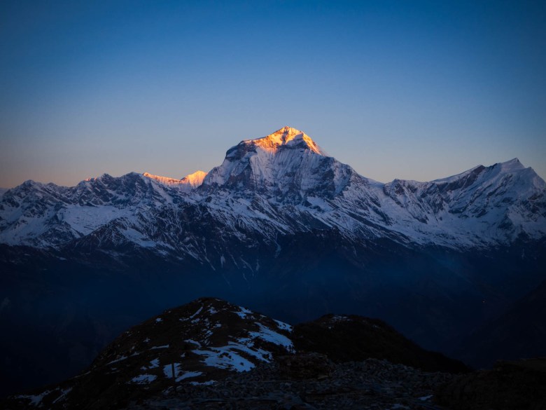
The views got insanely good as soon as I’d left the tree line near Chistibung and I was walking through snow and gazing at snow capped mountains around me. After the trail reached its highest point (3600m) it began to snake around the ridge to where the community lodge at Khopra Danda.
I could see Dhaulagiri, the seventh highest mountain in the world, in front of me. The ridge must have had heavy snowfall overnight as the trail was completely gone. I cautiously moved toward the lodge, using my walking pole to stab the snow in front of me to check for solid ground. A few times my foot fell through up to my knee but otherwise, it wasn’t too bad.

I stumbled into the lodge to discover I was the first one to arrive and the two managers greeted me. It was only 11.30am and I, along with the couple who’d been in the same lodge as me the night before, enjoyed the incredible view from the ridge all afternoon. It had insane views of Dhaulagiri in the distance and Annapurna South right in our face.
As the sun began to set, the temperature dropped to below freezing and we were inside the dining room staying warm. A large German trekking group arrived as well as another couple of people who arrived late and soon the lodge was full.
Of course, as the lodge was part of Mahabir Pun’s community trek it had WiFi available and some of the best WiFi I’d found in Nepal, all the way up at 3600m! The dining room was a noisy affair with 15 German trekkers and their full team of porters and guides, and us few independent trekkers. By 8pm, however, people slowly started heading to bed.

Day 5: Khopra Ridge to Dobato
Distance: 11km Time: 6 hours Descended: 800m Ascended: 600m
I rose just before the sun at 5.45am to a cloudless sky and clear view of the mountains. Wrapped in all the clothing that I had, I waited until the sun rose and boy, was it an unbelievable sight. I had seen photos of the Himalayan peaks lit up a bright orange as if on fire as the sun hit them first thing in the morning, but to see it with my own eyes was something else. A memorable sunrise if there ever was one.
There is a side trip to Khayer Lake from Khopra which takes you up to 4600m and is apparently an exceptionally beautiful place, however, the trail was closed at the time due to the snow and impossible to reach.
So after breakfast I headed back down to Chistibung again, making it down in only 1.5 hours. From there I turned left and headed for Dobato. The trail undulated through forest before descending steeply down to a river. I knew then that I would have to climb steeply and regain almost all the elevation I’d just descended.
On the way up to Bayeli, the trail trudged through heavy snow again and I slowed down as I found myself slipping and cursing my way through it. I arrived in Bayeli and knew I needed a rest so stopped for some lunch there where some other trekkers had a similar idea. From there it was 2.5km to Dobato on a fairly flat trail, but the snow continued making it hard work. By the time I got to Dobato, thick cloud had rolled over the mountain and I’d had enough snow for one day.
Dobato was busy with trekking groups and I took the opportunity to ask some guides about the upcoming weather report and conditions on the trails. I had originally planned to link up with the Annapurna Base Camp trail in Ghandruk but they all warned me against it, the weather was turning bad again and the risk of avalanches was high, with one already killing a trekker and his guide just a few days before.

Day 6: Dobato to Ghandruk
Distance: 12km Time: 5 hours Descended: 1420m
I was up again before 6am, this time to head up to Muldai Viewpoint at 3640m where there was yet another exceptional view awaiting me. It was a steep climb up from Dobato and heavily packed with deep snow and ice. A walk that would have usually taken me 20 minutes, took nearly 45 minutes as I cautiously scrambled up to the top. The sun had well and truly risen by then but the view was pretty incredible.
Dhaulagiri was in the distance, Annapurna I was right in front of me, along with Macchapuchare (or Fishtail) and even Manaslu was off to the far right. The Annapurna region’s most exceptional panorama. There was only a handful of people sharing the hill with me and I stayed to soak up the view despite the freezing air. On the way back down, I slid parts of the way, as there was simply no grip on the slippery ice and only some protruding trees to grab on to.
I was back for breakfast and then left at 9am to head down further. The snow continued for an hour and that was enough to frustrate me. However, as soon as it thinned out and the dirt trail was visible again I was flying along at a good pace. It was a foggy morning lower down and I wanted to make it to Ghandruk before the rain in the afternoon.
I made it to Tadapani, a major trekking junction and popular place for short hikes, by 11.30am and was already hungry, so I ordered a dal bhat for lunch. When the lady came around for any refills, I said yes to all of them.
Tadapani was a busy place, and I saw more trekkers than I’d seen in total for the last few days all dressed in their crisp new trekking gear. As I continued down to Ghandruk the trail was crowded with people heading up (it’s an alternative route to Poon Hill). Eventually I was down in the mossy forest again with blooming rhododendrons, meaning I was back in a much lower altitude.
I picked a guesthouse in Ghandruk and the rain rolled in not long after. The weather was not looking very good and so I reluctantly planned to head back to Pokhara and try a different trek elsewhere in the region instead.

Getting Back to Pokhara
From Ghandruk, the only way to get back to Pokhara was to walk back along a dirt road to the start of the motorable road and hope to catch a bus or jeep. So I headed off and just 1.5km out of Ghandruk I found a group of jeeps waiting. When I asked how much, they wanted 1000 rupees (AUD$12) per seat. It was expensive but I knew that was because they were specifically for tourists rather than locals so I kept walking.
Another 1.5km down the road I arrived in a town called Kimche and I asked for buses to Pokhara. A man said I had to wait and one would come through within an hour. I sat to wait and judging by the dead quiet town I figured I could be waiting a long time. Five minutes later a jeep pulled up full of locals and the driver asked if I wanted a lift for 400 rupees. I couldn’t say no to that.

Khopra Ridge Trek Accommodation
Accommodation was pretty standard across the whole trek and consisted of a basic room with a single bed and shared bathroom. The first couple of nights I got a bed for free but after that I was charged around 200-300 for a room (AUD$3-4). In Ghandruk, I paid 500 rupees (AUD$6).
WiFi was available for free in Ghorepani, Khopra Danda and Ghandruk and hot showers were widely available but for a fee.
Food
Menus were almost identical with numerous variations on three basic staples, pasta/noodles, rice and potatoes. Dal bhat as always was the most cost effective choice, with free refills. Prices didn’t change as much as expected, even as I got higher. A dal bhat with chicken was 650 rupees in Tirkhedhanga and rose to just 750 rupees for a veg option at Khopra.

Trail Navigation
Red and white markers are used in the Annapurna Conservation Area for main trails and that is what I followed up to Ghorepani and again from Tadapani down to Ghandruk.
Blue and white markers are used for minor trails which includes Khopra Ridge. Other than the section from Ghorepani to Swanta, the markers were pretty consistent and meant that having a map was unnecessary.
Although having Maps.me working on my phone was vital, especially with the snow obscuring parts of the trail. The lodge owners and guides I met were always helpful to answer any questions too.
Cost of Khopra Ridge Trek
Permit and park fees: 5000 rupees (AUD$65)
Sleeping bag rental: 1200 rupees (AUD$15)
Snacks: 1000 rupees (AUD$12)
Meals and accommodation: 11,200 rupees (AUD$145)
Transport (to and from): 600 rupees (AUD$8)
Total: AUD$245 for six nights, seven days
More Trekking Guides for Nepal
- Gokyo Lakes: How to Complete the Gokyo Lakes Trek from Salleri
- Jomsom: A Guide to Jomsom to Muktinath Trek in Nepal
- Langtang Valley: A Guide to the Langtang Valley Trek
- Trekking Tips: 10 Essential Tips for Trekking in Nepal
- Responsible Travel: Responsible Travel Guide to Nepal
Pin this post


Hi Elisha,
Great blog. Very informative. Can you please let us know when you did this trek? We are planning to do this trek, this year during October – November.
Thank you! I did this trek in March 2019. I think October-November would be a great time though as well. Hope you enjoy it!
Thank you for the quick response. Any idea how can we get the gpx file? We are planning to do it by ourselves. Your guidance is greatly appreciated
Sorry, I didn’t use a GPS and I’m not sure where you’ll get GPX files. The track was well-marked and I had a paper map of the area which you can buy anywhere in Pokhara or Kathmandu.
A well-marked track is great. Thank you for sharing the information 🙂 The way you have documented all the treks and travel in detail is great!
Your writing virtually took me to the trail.very well written.
Very keen to trek with you..
are there any steep drop offs or bad suspension bridges on this hike?
Suspension bridges on this trek are pretty good, similar to what you find on other popular teahouse trails in Nepal – they are not wood, rickety old bridges. A few steep drops I guess on the walk to Khopra Ridge teahouse, but that was mostly because it was snowed in when I was there – if the trail is clear it won’t be too bad. Hope that helps!
thanks, i heard from everest base camp trekkers that they kept on being harassed by authorities because they had no guides, is this a problem or any such experience? we like to hike alone.
I’ve never heard of this. It’s perfectly fine to hike teahouse treks alone if you have hiking experience. I was alone and never had any problems. On other treks where special permits are required, this is different but to Khopra Ridge you should be fine!
Dear Elisha, thank you very much for your detailed story, it’s very inspiring and helpful. I’m going to try your route in Febuary. Best wishes!
Great! I hope you enjoy it!
Thank you Elisha, greatly appreciate the details in your post. It sounds safe to do this trek alone. My question is whether the accommodations along the trek need to be prebooked, or can they be prebooked? If it runs on a first come first serve basis, I wonder if you would run into situations where you won’t get a place to stay for the day/night?
Hi Vivian, glad it was helpful! It’s definitely a safe option. I don’t think the teahouses can be booked unfortunately, which is definitely a bit tricky. It got pretty crowded at Khopra Ridge, because there’s only 1 teahouse available. But they will always find somewhere for you to sleep (although guided groups often get priority). It will depend on the time of year you plan on going, but generally it’s still a quieter trek than others in the region.
Hi! Thanks a lot for the post, very helpful!:) I’ve read some articles where people do the treck in the opposite direction (so Ghorepani on the way back), do you think it might be better? I would also like to ask if you know a place to leave my luggage in Pokhara while I do the trek. Thank you!
No problem, glad it was helpful! You can definitely do it in the opposite direction, as some people add it onto the Annapurna Circuit, so it would be fine to do that way too. Either way, you’ll see plenty of people on the trail. In Pokhara, I just left my luggage with my hostel, I think most accommodation places offer storage while you’re hiking, so ask them. Enjoy!
For info:
Foreigners are no longer allowd to solo trek without a guide in Nepal
Nepal Tourism Board (NTB), the country’s national tourism promotion body, which includes trekking and mountaineering associations, on Thursday 2 March 2023, decided to make a guide compulsory for solo or free independent trekkers (FITs) from April 1, due to increasing safety concerns.