
What certainly has to be one of the best multi-day hikes in Victoria, the Mount Bogong Circuit Hike offers the best views you can get in the state. Climbing to the highest mountain in Victoria, twice if you start from Mountain Creek like me, means this is not an easy hike. Yet, the challenge is rewarded with expansive mountain panoramas every day and camping at some of the best huts in the High Country.
Forming a loop up and around Mount Bogong, this 56km circuit includes camping at Ropers Hut and Cleve Cole Hut as you explore the slopes of the mighty mountain. I’d learnt about this circuit from another hiker and planned all year to complete it in the coming summer.
Despite a freak snowstorm dumping quite a bit of powder across the peaks in the days prior, the four days hiking around Mount Bogong turned out to be a highlight of my summer. For experienced hikers, this circuit is definitely one to add to your list. Here’s everything you need to know!
Disclaimer: This post contains affiliate links which means I get a commission if you buy a product through my link at no extra cost to you. By doing so, I can keep this blog going and continue to create helpful guides for you. Read more: Privacy Policy
Basic Facts About the Mount Bogong Circuit
Total distance: 56.5 km
Recommended time: 4 days
Total ascent: 3,345 m
Total descent: 3,321 m
Start/end: Mountain Creek Campground and Carpark
Circuit direction: Anti-clockwise or clockwise (I went anti-clockwise)
Difficulty: Hard
Location: Alpine National Park
Closest town: Mount Beauty
Respect: Bogong is the Aboriginal word for big fella – the name the local Yiatmathong people gave Victoria’s highest mountain. It was a source of significant food where Traditional Owners collected Bogong Moths.

Getting There and Away
Mountain Creek Campground and Carpark is 360km from Melbourne or a 4.5 hour drive. It’s a beautiful drive via Seymour, Euroa, Benalla, Milawa and Myrtleford.
The carpark is perfectly safe for you to leave your car for multiple days. It’s also a free public campground, so there are lots of people coming and going, especially on the weekends.
If you want to start the first day early in the morning (highly recommended), then you can either camp at Mountain Creek Campground or for more luxury, stay in Mount Beauty. This is the closest town and just 12km from the trailhead.
Mount Beauty has a great caravan park as well as other accommodation options.
Nearby Accommodation
Kiewa Country Cottages || Just outside of Mount Beauty, it’s perfect for a weekend escape. They offer two bedroom cottages set amongst a pretty garden on the property. Each cottage is self contained, plus there’s an outdoor pool and fireplace to relax before or after your long hike. Check availability here.
No. 43 Loft || Located on the highway just before Mount Beauty, this loft accommodation is a cosy spot for a couple or solo hiker. The modern apartment has a kitchenette, private bathroom and a balcony with mountain views. Check availability here.
The Park Mount Beauty || This is the only caravan park in Mount Beauty. It’s a beautiful spot right on the river with plenty of green grass. They have powered and unpowered camping, as well as cabins. Check it out here.

Mount Bogong Circuit Direction and Alternative Route Options
As with any multi-day hike in the High Country, there are varying route options with this circuit around Mount Bogong. The typical loop includes three camping spots: Bogong Creek Saddle, Ropers Hut and Cleve Cole Hut. This circuit can be done in either direction you choose. I decided to do it anti-clockwise, staying at Bogong Creek Saddle first.
The reasons for this were that I’d have the longest day on the first day when my legs were fresh and the deeper river crossing was then on day three, giving the water level time to recede a bit after the snowfall and heavy rain. This paid off quite well for me, but it really wouldn’t matter whichever way you do it.
Alternative: Starting From Falls Creek
The other variation of this loop is the starting point for the hike. I started from Mountain Creek near Mount Beauty, but you can also do this loop from Falls Creek. Starting from Falls Creek is technically a bit easier, as you don’t have to climb up and down the Staircase Spur of Mount Bogong and you’re naturally starting at a higher elevation so total ascent and descent over the four days would be lower.
If you wanted to start from Falls Creek instead, you can park your car at the Falls to Hotham Alpine Crossing trailhead, also known as Heathy Spur Trailhead, which is right on the edge of Rocky Valley Dam. Otherwise, the campsites are still the same for the hike. From Falls Creek, you would head to Ropers Hut for the first night on the Australian Alps Walking Track, and then do the circuit in whichever direction you choose, spending a night at Bogong Creek Saddle and another at Cleve Cole Hut.
Watch My YouTube Vlog Below!
Trail Notes: Mount Bogong Circuit Hike
Here’s my personal experience on the trail, including my daily stats. This should help you get an idea about completing the circuit, including the challenges and highlights.

Day 1: Mountain Creek to Bogong Creek Saddle
- Distance: 17 km
- Time: 8 hours
- Ascent: 1,546 m
- Descent: 798 m
By the time I got organised and ready to go, it was around 9.30am. I left my van at Mountain Creek where I’d camped the night before, and headed off up the vehicle track to the trailhead of Staircase Spur.
The sun was streaming through the trees, heating the soaked vegetation after many days of rain. I’d postponed the hike a couple of times in the previous week due to bad weather, so I was already assuming I may see some snow at the summit.
I’d climbed Mount Bogong as a day hike last year, so I was very familiar with the extremely steep ascent. Yet, carrying a much heavier pack this time around, I was definitely a lot slower going.
I made it to Bivouac Hut after around 6km of walking and desperately needed a break. I sat down to find the area busy with day hikers coming and going already. There was only around 3km left to the summit, with the next 1.5km still below the treeline. The trail got rockier and more rugged, but still just as steep.

Once I finally emerged above the treeline, I gazed up at the summit of Mount Bogong covered in a glistening layer of white snow. And I was excited to get up there.
As I pushed on, I came across the first dregs of snow on the side of the trail. Further up to the last few hundred metres and I was climbing through a waterfall with the snow melting fast under the hot sun.


The last 200m was completely covered in snow as I made my way up to the large rock cairn at the summit. I got to the top of Mount Bogong at 2pm. The view was certainly the best I’d seen in the High Country, with the snow adding that extra touch of magic.
I spent almost an hour around the summit, taking in the view and meeting a couple of other overnight hikers who’d been caught out in the snow storm the day before.
The clouds were coming in thick and fast across the west side, so I quickly headed off in that direction. I was a little nervous of the cloud cover potentially obscuring the trail down Quartz Ridge that was already covered in white. But I was lucky, as the cloud never completely covered the summit and it remained clear for the afternoon.

The snow was much heavier on this side of the mountain, and with no footprints at all to follow, I could only just make out the trail through the snow. It was hard work, but a spectacular trail with exposed views across the entire Victorian Alps. I stopped many times to just soak it all in, with a grin from ear to ear.
The steep descent slowing got to me though. It was tough, and my legs were tiring after a long day. Once I got below the treeline again, the trail was pretty rough and a little overgrown, but still visible enough to follow.

I finally got down to the Big River Firetrail, relieved that I was nearly done for the day. The stream across from the T-intersection coming through the culvert was the only access to water for the night, so I refilled my bottles and hydration reservoir.
I then turned right and headed up the firetrail about 150m to the saddle camping area. It’s not an official spot, but the most convenient and I could tell often used by hikers in this part of the Alpine National Park. I arrived at 6pm and by the time I set up and had dinner, I was asleep by 9pm.


Day 2: Bogong Creek Saddle to Ropers Hut
- Distance: 13 km
- Time: 4.5 hours
- Ascent: 616 m
- Descent: 270 m
It had been a perfectly still night and quite mild. I still didn’t get up and going until just after 9am. I knew it was only about 12km or so and mostly on a fire trail, so I wasn’t overly worried.
I headed back down Big River Firetrail the same way I’d come up the day before, passed the turn off for the Quartz Ridge track I’d come down, and continued down to Big River. I’d only done 1.5km and I reached the river crossing. It was very low, only about mid-shin deep which was nice (it was the other crossing of Big River the next day that I was more worried about).
From there, the fire trail was basically uphill for most of the rest of the day. It zig-zagged up for the next 6.5 or so kilometres. I had a decent break, sitting in the middle of the trail at around the 6km mark for the day.

BUY THIS: Ottie Merino Hiking T-Shirt, Made and Owned in Australia
I needed to put some music on after that, my motivation was waning and my legs were tired. It’s surprising sometimes how much of a difference some music makes for me. Not long after that I popped out above the treeline again, and the views across to my right were spectacular. I could see across to Mount Buffalo National Park, The Fainters (where I’d been just two weeks before), Mount Jaithmathang, Spion Kopje, Grey Hills and Falls Creek.
It started to flatten out then too. I came across some pretty fresh dog footprints on the trail, but never spotted any during the day. I stopped for lunch just off the trail after about 10.5km. I could see the trail continuing in front of me until it linked up with the Australian Alps Walking Track (AAWT).
I spotted a solo hiker in the distance coming up from Ropers Hut and heading to Falls Creek. I hadn’t seen anyone since Mount Bogong summit the day before, but obviously never caught up with that person either.

I continued on the fire trail and turned left onto the AAWT as it headed to Ropers. Not long after that I made it the hut at 2pm. It was a beautiful spot amongst the snow gums, and a perfectly clean hut.
There was a sketchy little trail heading behind the hut and down to a creek, the only source of water. I finally picked a spot for my tent, even though I had a huge area to choose from, enjoyed afternoon tea and then lay around reading a book and listening to a podcast until 5pm. Then, it was entrée time with noodle soup, before dinner which was butter chicken and rice from Strive Meals.
At sunset time, I headed back up the trail I’d come that day to just above the treeline. I got a stunning view of Mount Bogong with the changing colours of the sky.


Day 3: Ropers Hut to Cleve Cole Hut
- Distance: 13.5 km
- Time: 7.5 hours
- Ascent: 915 m
- Descent: 852 m
Another beautiful night in the alpine region and a warm morning. I got moving at about the same time as the previous couple of days, just after 9am. Although I knew it was only about 12km to Cleve Cole, I also knew it was potentially going to be the most challenging day.
This was the day I’d been most concerned about. The descent down Duane Spur was a really rough descent. While only about 4km or so, it was on a very skinny and overgrown track. Welcome to the real AAWT.
The first couple of hundred metres had been recently cleared, with trees chopped. But after that, I was climbing over fallen trees, pushing back branches and shrubs, nervously putting my foot down in long grass, all while sweating in the morning sun.

I was slower than I thought I’d be, averaging only about 1.5-2km per hour. I’d also lost a good 20 minutes with a flighty snake that was on the trail and made some sudden movements when I got closer. I had to make my way around it through the bush.
Once I could hear the river running below, I was both relieved and anxious. I wanted the descent to end, but I was unsure how deep the river crossing was going to be. I’d had some people in the AAWT Facebook group tell me it had not been that high just the week before, but after all that rain and melting snow, I was scared it may have risen again (it can rise to up to chest height after rainfall).
The trail seemed to end just down at the river, but I couldn’t see how to get across. I looked down the river to my right and I could see the new chain that had been put across a bit further down. So, I bashed my way through the long grass and thick vegetation on the banks of the river to get to the crossing.

The water was only up to just below my knees. Relieved was an understatement. I was very happy. I was also mentally exhausted. I sat on the other side of the river, filtered some water and had a good break.
Then, the ascent up T Spur began. The trail was skinny, but a little clearer than Duane Spur. It was a brutal uphill slog though, and I soon put on some music to keep my motivation high. The first couple of kilometres were steep, then it flattened a little, before beginning another steep climb up to the intersection with Long Spur.
There were some trees to climb over and some long grass to navigate through, but overall the trail was easier to follow. Once the vegetation thinned out a bit, I was a little faster. I bumped into a solo hiker heading down, and he’d been as slow as me on his descent. He didn’t think he’d make Ropers Hut, so I told him there was a decent camp spot on this side of the river, but nothing afterwards, if he needed.


I finally met the intersection with Long Spur. The AAWT turned right there, but I turned left to head to Cleve Cole. I was pretty happy to say goodbye to the AAWT, knowing that the trail from here on out would be more defined.
I got to the turn off for Howmans Falls. I’d heard they were pumping at that time, which is unusual for summer. So, despite being exhausted and the afternoon running away from me, I decided to take the 800m detour to the falls. The trail followed the creek to the edge of an escarpement with a few cascading falls along the way. At the end there is a big long drop, but you can’t quite see the waterfall itself dropping down into the valley.


At that very end point, I came across a huge Alpine Copperhead curled up. I quickly decided the waterfall was not important and I headed back again. On the way back, I came across another copperhead on the trail and I had to go around it by climbing up the slope a little. By the time I made it back to Long Spur, I wasn’t sure the detour had been worth it!
I finally made the last climb up to Cleve Cole Hut, arguably one of the best huts in the Australian Alps. I was surprised to find that it was a tent city, with a school group doing an overnight hike up Mount Bogong. I then met three guys who’d paraglided up the mountain and camping the night, plus a solo hiker who was doing the same loop as me in the opposite direction.
I was pretty tired, so I found a spot tucked away from the hut amongst the snow gums and made my dinner. I went to collect water from the hut (which has proper plumbing!) and got talking to the paragliders. They were super interesting guys and I managed to score myself a free tandem flight with Phil, who stayed true to his word and gave me a morning flight a few days later! The people you meet in the mountains!

Day 4: Cleve Cole Hut to Mountain Creek
- Distance: 13 km
- Time: 4.5 hours
- Ascent: 268 m
- Descent: 1,401 m
I’d listened to wild dogs howling all night on the slopes of Mount Bogong. And I still didn’t get going until about 9am. The sky was clear again and the air quite still, so it was a stunning walk across the high plains towards the summit. I’d never walked up this side of Bogong, so it gave me quite a different perspective as I got close to the peak.
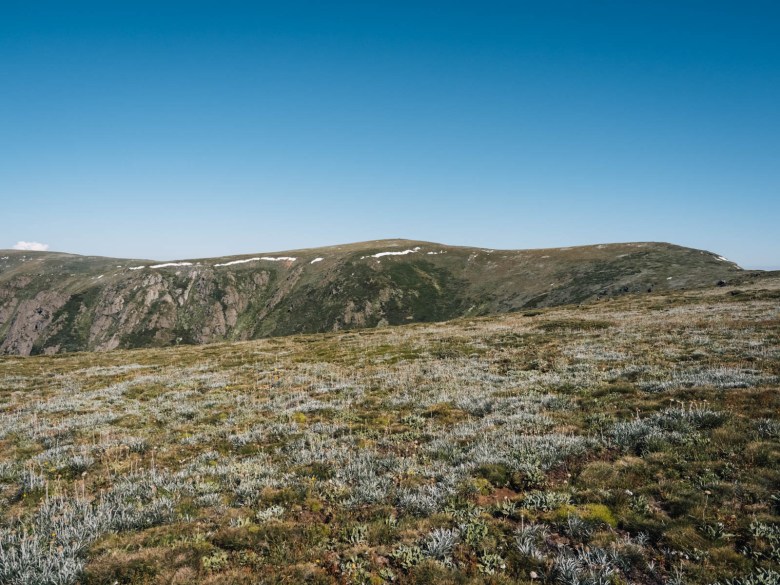
I got to the summit at around 10am, having walked the nearly 4km quite quickly (it was probably some of the easier walking of the whole circuit!). Almost all of the snow had melted away already, with just a few patches remaining, which was incredible.
I met up with the paragliders again, who were assessing the air and deciding when to jump off. I spent nearly an hour up at the summit just taking in the magnificent view from the roof of Victoria.

I said goodbye to my new friends and headed back down the Staircase. I met a few day hikers going up. The steep descent down the spur back to Mountain Creek was long, but the first half offered incredible views. The last few kilometres through the forest dragged on a bit, but I was stoked to have finished this Mount Bogong Circuit Hike that I’d wanted to do for over a year.
It was so much warmer back down at Mountain Creek, that I grabbed a cold drink from my van and then jumped into the icy river to cool off. Adventure complete!

Essential Information for this Multi-Day Hike
If you want to complete this circuit hike yourself, here’s some useful information you’ll want to know, including campsites and water sources.
When to Hike Mount Bogong Circuit
The summer season or green season is the best time of year to do this circuit. This season runs roughly from October until April, depending on snowfall. Over these warmer months, the trails are mostly cleared of snow (unless there’s a freak snowstorm in summer like I had in the days leading up to my hike!) and the skies are clearer.
I did this hike at the start of February. After postponing it a couple of times due to the extreme weather, I had four days of perfect conditions. However, it can get quite warm on the descents, as you do drop below the treeline a few times. However, generally the nights are more mild and the air still cool enough to walk comfortably.
Weather can change rapidly and without warning in the alpine region though, so you must be prepared for all conditions. Pack accordingly, the alpine requires you to think four seasons even in summer. Some of my packing recommendations are below.

Camping on this Circuit Hike
This circuit hike has three nicely spaced camping spots over the four days. Two of them have huts and toilets, while the other has no facilities at all. The campsites are:
- Bogong Creek Saddle: Apparently an old helipad, this flat area next to the Big River Firetrail is perfect for a wild camp. There are no facilities at all and no marked sites. Water is usually reliable from the stream down from the campsite, across from the intersection of the firetrail and Quartz Ridge track. You can get down to the culvert where water is usually found. No phone signal.
- Ropers Hut: One of the most picturesque High Country huts, Ropers is on the Falls Creek side of the region and is accessed via the Australian Alps Walking Track. It’s situated amongst a large flat area of snow gums, with lots of places to pitch your tent. There is a toilet. Water can be found usually all year round in a creek behind the hut. There’s a sketchy trail that leads down to the creek. You’ll get phone signal just back up the trail a bit.
- Cleve Cole Hut: Widely regarded as everyone’s favourite backcountry hut in Victoria, Cleve Cole Hut is an old stone hut. It has a couple of toilets, and even running water through the plumbing in the hut. There’s lots of space amongst the snow gums around the hut. It can get quite busy on weekends, as it’s used for Mount Bogong overnight hikes as well as longer treks. Good phone signal.
Read next: How to Leave No Trace and Respect the Outdoors

Safety
Serious dangers mainly come in the form of injury or snakes. Make sure that you carry a first aid kit, including a snake bite bandage, in case of emergency.
I saw three snakes all on day three, so there’s plenty of them out there when the sun is shining. Generally they’ll be Alpine Copperheads, so they’re pretty placid unless provoked. Give them plenty of room to safely move off the trail or give them a very wide arc if having to walk around them – never take your eye off where they are though, they can move suddenly.
Navigation
Navigation on this hike is generally okay with minimal GPS help. However, a couple of sections were a bit overgrown, although with some hiking experience, the trails were still faintly visible to the trained eye. I definitely recommend having some sort of navigation app on your phone.
Maps.Me has these trails accurately marked or you can map the route on Gaia or Avenza for something more detailed. You should also carry a paper map and compass for longer hikes like this in the alpine region for when visibility is poor or your technology fails.
I’ll give some more navigation details here from my experience:
- Mountain Creek to Mt Bogong summit: The Staircase is well maintained and highly trafficked, so you won’t have any problem following this trail to the summit.
- Quartz Ridge from summit to Big River Firetrail: This trail is generally visible across the west side of Bogong even with minimal snow poles to follow. Under snow it was a little harder to follow, but without snow you should be able to easily see the footpad. Once it drops below the treeline, it does become quite skinny with some long grass and tree branches down. It’s still visible though if you pay attention.
- Big River Firetrail to Ropers Hut: This is obviously quite easy to follow, being a wide management track.
- Duane Spur and T-Spur: These are the toughest sections but they are still visible to the trained eye. Both spur trails have trees down and lots of regrowth and overgrown bushes which can obscure the trail. However, if you’re attentive, you can generally still see the footpad. There were a handful of AAWT signs on trees that I saw, but not enough to rely on.
- Cleve Cole Hut to Bogong summit: This is highly trafficked by overnight hikers, plus it’s above the treeline so you won’t have any problems following it. Although I actually found it hard to pick up the start of it at the hut. It begins from behind the hut, heading straight up through the trees away from the toilets.

Water Sources
I’ve detailed some of the water sources at the camping sites above, but I’ll list them here too. Water is generally pretty reliable on this Mount Bogong circuit hike, however, if it’s been a dry winter and hot summer they may be just a trickle. Always ensure you fill up as much as you can when you find reliable water, or get some up to date information through Facebook groups like the Australian Alps Walking Track or Hiking in Australia and New Zealand groups on current water supply.
I use a Sawyer Squeeze for water filtration in the alpine region.
Water can be found at the following places:
- Bivouac Hut on Staircase Spur: There is a tank there but it’s often dry in summer due to the amount of day hikers using it. Not reliable. I carried enough with me from Mountain Creek for the entire first day until camp.
- Bottom of Quartz Ridge Track: At the bottom of the trail when it comes out onto the Big River Firetrail, there is a small stream running. You can easily fill up from the culvert under the firetrail. It’s pretty reliable, but can slow to a trickle if there hasn’t been rain in a while.
- Big River (first crossing): Just a couple of kilometres from Bogong Creek Saddle, you need to cross this river which runs basically all year round.
- Ropers Hut: There is a creek behind the hut accessible by a short rough trail that gets down to the edge. There was a lot of water when I was there and generally it runs all year round.
- Big River (second crossing): At the bottom of Duane and T Spur, there is another crossing of the Big River where you can fill up.
- Intersection of T Spur and Long Spur: There is a small creek which you need to cross at the intersection of these two spur trails on the AAWT.
- Camp Creek: From the intersection mentioned above until Cleve Cole Hut, Long Spur follows Camp Creek so there’s plenty of chances to fill up there. This runs basically all year round too, unless it’s exceptionally dry year.
- Cleve Cole Hut: There is running water in the hut from the creek nearby. I’ve never heard that this has ever run dry, so it’s pretty reliable.
Read next: How to Plan Your Food for Hiking

Essential Gear to Pack
Sleeping bag | You’ll want a good sleeping bag for the High Country, one that will keep you warm no matter the temperature and be lightweight enough to pack easily in your backpack. Sea to Summit is one of the best brands on the market and you can’t go wrong with their Spark -9 degree bag.
Backpack | A 65L pack is usually a good option for multi-day hikes, especially in the Alpine region when you’re going to be carrying warm gear.
Hiking boots | I’m a bit old fashioned when it comes to my footwear and I can’t hike without my hi-cut boots. I’ve been wearing Keen Targhee boots for a couple of years and I’m super happy with them on all adventures.
PLB | Any hiker, especially a solo hiker, should carry a Personal Location Beacon. For the cost, these small devices can save your life anywhere, anytime. If you don’t want to buy one, you can hire one from any Macpac store, find out more here.
Power bank | I rely on my phone (maybe too much) while I’m hiking. From Maps.Me to recording videos to listening to music, I can recommend the BioLite power bank which will easily last days off the grid.
Tent | Try to keep your tent below 2kg as this can quickly become your heaviest piece of gear. I currently have the Big Agnes Copperspur 2-person tent, and it’s been my go-to for all my alpine hiking adventures.
Down jacket | You should be prepared for any weather on alpine adventures, so a down jacket is a must to ensure you keep warm. This Patagonia Nano Down is lightweight, warm and water repellent, so it’s perfect for the High Country.
Read next: My Complete Overnight Hiking Packing List
Other Multi-Day Hikes to Do Nearby in the Australian Alps
- Three Day Hike From Hotham via Mount Feathertop and Dibbins Hut
- Falls to Hotham Alpine Crossing
- Three Day Hike to The Fainters From Hotham
- Three Day Loop Around Falls Creek via Mount Jaithmathang and Cope Hut
Pin this post


[…] Mt Bogong summit. It connects Ropers Hut with Mt Bogong, making it popular for those completing a multi-day hike around the Falls Creek and Bogong […]
Hello, thanks so much for this post, which was really helpful. We walked this trek from 4-7 November 2023. A few updates:
1. The track to Cairn Creek Hut has recently been recut, so that is a possible side trip / extension.
2. The track from Ropers Hut to the creek has recently been recut, so water is readily available there.
3. The track along Duane Spur has recently been recut, so while it is still steep, it is not difficult to find your way or negotiate the scrub.
There was no snow on the track, so we did not find it difficult to find at any point.
Thanks Tom for the update! I’d heard they had cleared Duane Spur which is amazing, it was getting pretty bad last year. Hope you enjoyed your time out in the Aussie Alps
I came here to to say the same! I walked from 2-5 Nov 23.
Thanks for your blog on this walk Elisha, it certainly made for easier planning re water sites and researching how to do water crossings (I took my Vibram 5 fingers).
I did the walk from November 2-5, 2023: weather-wise, there was little to no wind; a mild night at Saddle Creek to very cool nights at Ropers and Cleve Cole….and Ropers had a number of magpie nests that were being fiercely defended. Such a beautiful, challenging and re-vitalising hike 🙂
Thanks so much for this post. It was super helpful for planning my circuit over 28-31 Dec 2023. We did the trip coming from Falls Creek and slept at Edmonsons and Johnston’s Hut on the way there and back.
Very helpful post thank you. Soled this early March 2024. A beautiful walk and was amazed to have the trail completely myself!!
Thanks Michelle! So glad you enjoyed it 😊
[…] four-day circuit of about 56 km is documented by Beyond Wild Places, an Australian hiking outlet, using camps at Bogong Creek Saddle, Ropers Hut, and Cleve Cole […]