
After visiting Tawonga Huts as part of a three day loop hike at Falls Creek last year, I’d wanted to return to hike out to the Fainters. This twin set of peaks sticks out from a ridge that stretches away from Falls Creek towards Mount Beauty. Being above 1800m, they offer one of the best views in the Aussie Alps, including over to Victoria’s highest peaks, Mount Bogong and Mount Feathertop.
Despite Tawonga Huts being closer to Falls Creek, I decided to head to the huts and the Fainters from Hotham, making it an extended three day, out and back hike. I used part of the Falls to Hotham Alpine Crossing, before turning off to the historic huts and camping area, from where I took the Fainter Fire Trail as a day hike.
Whether you’re looking for a side trip to the Falls to Hotham Alpine Crossing, or just interested in new peaks to climb in the Alpine National Park, I can highly recommend a trip out to the Fainters. And you’ll likely have the trail all to yourself. This guide details how to reach the Fainters, including where to camp and how to get there.
Disclaimer: This post contains affiliate links which means I get a commission if you buy a product through my link at no extra cost to you. By doing so, I can keep this blog going and continue to create helpful guides for you. Read more: Privacy Policy
About The Fainters
The Fainters are a set of twin peaks, Fainter South (1861 m) and Fainter North (1817 m). They stick out from a long ridge that stretches from near Pretty Valley, south of Falls Creek, towards Mount Beauty. The Fainters can easily be seen as you gaze across to Falls Creek from the top of Mount Feathertop, or from the nearby peak of Mount Jaithmathang, which can also be hiked from Tawonga Huts.
To reach the Fainters, you can take the Fainter Fire Trail which stretches from Pretty Valley to Tawonga Huts and then across the ridge of the Fainters and down past Bogong Jack Hut to Mount Beauty. It’s considered a multi-use trail, for walkers, mountain bikers and horse riders.

However, the name is a bit deceiving, as it’s not really a typical “fire trail”. It’s more of a single track hiking trail that you see in other parts of the alpine region. It can be rocky in sections too, so it’s really reserved for experienced mountain bikers. However, for hikers and horse riders, it’s a lovely day out, with a gentle ascent and stunning panoramic views.
The Fainter Firetrail is about 40km one way (from Pretty Valley down towards Mount Beauty), but this is generally not completed by hikers in its entirety. Instead, it’s usually completed as an out and back day hike from Tawonga Huts as far as Fainter North, before the trail begins to descend. This is what I did as part of a three day hike from Hotham to Tawonga Huts and back, and what will be described below.
Note: There is an off-track route from Mount Jaithmathang near Tawonga Huts towards the Fainters, but this is overgrown and should only be attempted with sufficient offtrack navigation skills. It’s best to stick to the Fainter Fire Trail from Tawonga Huts instead.

Starting Point for the Hike: Falls Creek or Hotham
You can reach the Fainters from either Falls Creek or Hotham.
Falls Creek is the closest of the two ski resorts and villages to Tawonga Huts. In fact, if you drive to Pretty Valley Pondage at Falls Creek, you can start walking from there and reach Tawonga Huts after just 4km on a wide track. This makes it an easy hike-in camp to base yourself in for both Mount Jaithmathang and The Fainters.
However, the road up to Falls Creek from Mount Beauty was closed in summer 2023, so that made it a bit difficult to reach Falls Creek. Plus, I also wanted more of a challenging few days out on trail. This is why I decided to do the Fainters from Hotham instead. It also meant doing half of the Falls to Hotham Alpine Crossing again, which is a great trail. So, I completed this walk to the Fainters out and back from Hotham.
If you want a shorter (and less challenging) option or perhaps just looking for an overnight hike instead of a three day hike, then you can certainly go to the Fainters from Falls Creek. Otherwise, the walk from Hotham is a fantastic option for those with more time and energy.
Can You Reach The Fainters on a Day Hike?
Short answer: yes! You could hike to the Fainters as a day hike from Falls Creek. If you started from Pretty Valley Pondage, it would be a 25 km return hike, if you went as far as Fainter North. This is certainly doable, for fit hikers, as the walk to the Fainters on the Fainter Firetrail is very gradual with nothing overly steep or challenging. However, you’d still be looking at a long day out of about 8 or so hours.

Getting There and Away
If you’re beginning from Hotham, like I did, then:
From Melbourne: Hotham Alpine Resort is 376km away from the CBD or nearly a 5 hour drive.
From Bright: The drive from this popular town to Hotham is 53km or an hour via the Great Alpine Road, making it an ideal place to stay the night before or after the hike.
If you decide to begin from Falls Creek, then:
From Melbourne: Falls Creek is 385 kilometres away from Melbourne or around 5 hours of driving.
From Mount Beauty: This small mountain town in the Kiewa Valley is just 30km away from Falls Creek, making it the perfect spot to stay before or after your hike.

Nearby Accommodation
If you plan on staying before or after your hike, there are options in Bright and Harrietville near Hotham, or Mount Beauty near Falls Creek. Check out some of these options:
Mount Beauty: Kiewa Country Cottages
Harrietville: Shady Brook Cottages
Bright: Edlin House
Prefer free camping? You can stay at Smoko Campground, which is off the Great Alpine Road between Harrietville and Bright. This is convenient for those planning on starting their hike at Hotham. Or, you can also camp at Pretty Valley Campground at Falls Creek. This is convenient as it’s where the trail to Tawonga Huts begins from that side. I’ve stayed at both of these camps in my van.

Parking Options
At Hotham, the Mount Loch Carpark precinct is still under construction (projected to be completed sometime in mid-2023). So, the best place to park is Corral Carpark, which is at the Hotham Resort Management Office in the village area. The management staff prefer hikers to park there for overnight hikes, as they can keep an eye on vehicles.
It’s best to go into the office to let them know how long you’ll be hiking for (they even dropped me at Mt Loch Carpark to save me the road walk!). But, it does add an extra kilometre or so at the start and end of your hike along the Great Alpine Road.
At Falls Creek, it’s best to park at Pretty Valley Pondage, at the end of Pretty Valley Road past the campground. While this is not sealed, it’s 2WD accessible and just 7.5km from Falls Creek Village. This is the start of the walk to Tawonga Huts from the Falls Creek side.

Three Day Hike to The Fainters from Hotham
Here’s a look at my three day hike to The Fainters from Hotham. As mentioned above, you could also do this hike from Falls Creek to shorten the distance to Tawonga Huts. However, I decided to tackle part of the Falls to Hotham Alpine Crossing from Hotham on the way, making this a decent three day outing in the Aussie Alps.
Day 1: Hotham (Mount Loch Carpark) to Tawonga Huts via Pole 333
Distance: 16.5 km | Time: 5 hours | Total ascent: 661 m | Total descent: 824 m
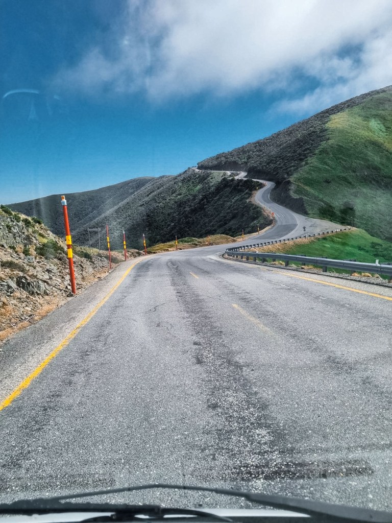
I didn’t arrive up at Hotham until late morning. I parked at Corral Carpark, just outside the Hotham Resort Management Office. I thought I’d better go in and tell them that my van would be left for three days in the carpark, and the staff offered to drive me to the trailhead at Mount Loch Carpark, which saved me 1km of road walking to start (Thank you!).
I walked past the Mount Loch Carpark, which is still under construction and headed off on Machinery Spur Track. This wide vehicle management track offers beautiful views across to Mount Feathertop and Mount Buffalo. The wind was howling, but the sky was clearing of cloud, making the views even better.

After about 2.7km, I had to turn off the track and onto a single trail signposted as the Australian Alps Walking Track (AAWT) towards Dibbins Hut. It crosses the plateau opposite Hotham, past the last ski lift, and drops down first to Derrick Hut.
After Derrick Hut, it’s a nice gentle walk through snow gums across a flat plateau. After 2.5km though, the trail takes a steep descent for the final 1.5km to Dibbins Hut, down what is known as Swindlers Spur. I had a much needed break in the camping area by the river at Dibbins, before beginning the steep ascent up the other side of the valley.

Usually, Dibbins Hut marks the end of the day for those doing the Falls to Hotham Alpine Crossing, but I was pushing onto Tawonga Huts. The first 3km after Cobrunga Gap is a steep climb up towards Falls Creek and the Bogong High Plains. Once reaching the top, however, it’s a much easier walk across a single track to Pole 333.
This is a major intersection in the alpine region, and is where I had to turn left towards Tawonga Huts (the Falls to Hotham Alpine Crossing heads right). It was a gentle couple of kilometres down to the huts from there, my camping area for the next two nights. I set my tent up and enjoyed the view for the rest of the evening.

Day 2: Day Hike to The Fainters from Tawonga Huts and Return
Distance: 16 km | Time: 4.5 hours | Total ascent: 457 m | Total descent: 463 m
I left most of my stuff in my tent at Tawonga Huts, and simply took a small daypack for my day hike out to the Fainters. It’s not obvious at first but the Fainter Fire Trail passes the turnoff for Mount Jaithmathang, before crossing a stream and continuing around the corner away from Tawonga Huts.

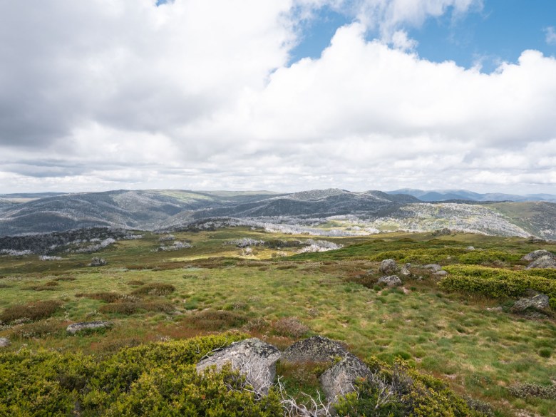
Once you’re on it, the rocky trail is well-worn and easy to follow. It’s never overly challenging, and provided a gentle climb most of the way. After crossing some open plains and through snow gums, the trail emerges above the treeline where you’re rewarded with panoramic views. I continued as it skirted around the ridgeline.

As the Fainter Firetrail continues all the way down towards Mount Beauty for horse riders and mountain bikers, there’s no obvious end point for the day hike to the Fainters. But, if you have an offline map app like Maps.Me, you’ll see when Fainter South is towering above to your left, and then Fainter North is the next peak on the ridge (the one with a pole on top).
To reach the peaks themselves, you have to go off-track and work your way through scrub to get up to the top. I could faintly see where some people had attempted to reach the peaks, but it was hard work. I found a nice rocky spot just under Fainter South, and enjoyed my lunch and the view from there.
I continued on the trail until it past by Mount Fainter North and was beginning to descend down to Bogong Jack Hut (another 2km away). This is when I decided I’d turn around and head back to Tawonga Huts. My watch showed I’d done about 8km, making it a 16km return hike. I returned on the trail and had the rest of the afternoon to relax at camp.

Optional extra hike up to Mount Jaithmathang and Return
Distance: 4.2 km | Time: 1.5 hours | Total ascent: 191 m
If you’re feeling restless at Tawonga Huts and want to add another little side trip, then I highly recommend getting up to Mount Jaithmathang. I’d already summited it previously, and decided to rest my legs and not do it again. But, the steep 2.1km walk from Tawonga Huts is a fun little climb that offers a 360 degree view across the Alpine National Park. A worthy sunset spot too!

Day 3: Return to Hotham from Tawonga Huts
Distance: 17.5 km | Time: 5.5 hours | Total ascent: 794 m | Total descent: 681 m
After my two nights at Tawonga Huts, it was time to head back to Hotham. I was basically retracing my route from day one all the way, so I knew I had another tiring day to get down to Cobrunga Gap and back up Swindlers Spur.
I left relatively early to avoid some bad weather that was coming in the afternoon. I climbed up to the Bogong High Plains quickly to Pole 333, before turning right back across the plains. I spotted a herd of brumbies across to my left. They were curious of me but never seemed bothered enough to move. I continued on the trail until I turned right again to stay on the AAWT.

I descended down to Cobrunga Gap and Dibbins Hut again. I only stopped briefly for a snack there, as I really wanted to beat the weather. So began my tough climb back up Swindlers Spur. It was my second ascent of the spur in the last couple of years, and it didn’t feel any easier. It’s tiring work, but as soon as it flattened out I picked up the pace to Derrick Hut.
I passed some hikers heading out on the Falls to Hotham Alpine Crossing, and I wished them luck with the weather for the night. From Derrick Hut, I ascended back up onto the ridge opposite Hotham Alpine Resort and then continued until reaching Machinery Spur Track. Then, it was just a matter of walking the ups and downs of the track all the way back to the Great Alpine Road.
This time, I had to walk the last kilometre back on the road to my van, beating the weather by about an hour. I arrived down at Harrietville and the storm hit, making the early morning worthwhile.
*My stats show an extra 1km despite being the same route as day 1. But this includes the extra 1km on the road to get back to my van at Corral Carpark, on the first day I got a lift to the Mount Loch Trailhead.

BUY THIS: Ottie Merino Hiking T-Shirt, Made and Owned in Australia
Essential Information for This Multi-Day Hike
If you’re interested in completing this hike, here’s some important information you’ll want to know, including camping, safety and gear.
Camping at Tawonga Huts
Located next to a mountain stream, Tawonga Huts were first established by John Ryder in the 1880s. It’s a really pretty spot to camp, with plenty of space and a drop toilet. There are four different huts, but these are reserved for emergency shelters in bad weather.
There’s beautiful grass to pitch a tent on though around the huts, and a beautiful view looking towards Mount Bogong.
You can easily collect water from the nearby streams, which usually flow year round. I would recommend filtering the water though, with the campground open to horse riders as well.
I use a Sawyer Squeeze for water filtration in the alpine region.

Safety and Navigation
This hike is a pretty safe option in the alpine region. The trails are well used, so it’s unlikely you’ll get lost. Most of the intersections have major signs, however, some of the obscure intersections can be a little confusing. I’d recommend having something like Maps.Me downloaded on your phone so you can double check you’re on the right track.
Serious dangers mainly come in the form of injury or snakes. Make sure that you carry a first aid kit, including a snake bite bandage, in case of emergency.
I saw three snakes on this three day hike to the Fainters, so they’re definitely out and about when the sun is shining. Be aware, but not afraid, Alpine Copperheads tend to be relatively passive when given space.

Essential Gear
Sleeping bag | You’ll want a good sleeping bag for the High Country, one that will keep you warm no matter the temperature and be lightweight enough to pack easily in your backpack. Sea to Summit is one of the best brands on the market and you can’t go wrong with their Spark -9 degree bag.
Backpack | A 65L pack is usually a good option for multi-day hikes, especially in the Alpine region when you’re going to be carrying warm gear.
Hiking boots | I’m a bit old fashioned when it comes to my footwear and I can’t hike without my hi-cut boots. I’ve been wearing Keen Targhee boots for a couple of years and I’m super happy with them on all adventures.
PLB | Any hiker, especially a solo hiker, should carry a Personal Location Beacon. For the cost, these small devices can save your life anywhere, anytime. If you don’t want to buy one, you can hire one from any Macpac store, find out more here.
Power bank | I rely on my phone (maybe too much) while I’m hiking. From Maps.Me to recording videos to listening to music, I can recommend the BioLite power bank which will easily last days off the grid.
Tent | Try to keep your tent below 2kg as this can quickly become your heaviest piece of gear. I currently have the Big Agnes Copperspur 2-person tent, and it’s been my go-to for all my alpine hiking adventures.
Down jacket | You should be prepared for any weather on alpine adventures, so a down jacket is a must to ensure you keep warm. This Patagonia Nano Down is lightweight, warm and water repellent, so it’s perfect for the High Country.

Other Hikes to Do Nearby in the Aussie Alps
If you’re looking for some other multi-day hikes to do around Falls Creek or Hotham, check out some of these options.
Three Day Loop Hike Around Falls Creek
If you prefer to complete a loop hike, then Tawonga Huts can also be incorporated into this three day hike around Falls Creek. The loop uses part of the Falls to Hotham Alpine Crossing, with a night spent at Cope Hut. Then, a second night spent at Tawonga Huts, where you could add either Mount Jaithmathang, or if you have an extra day, the Fainters.
Check out my guide to this three day loop hike at Falls Creek here.
Three Day Loop Hike from Hotham to Mount Feathertop
If you’re looking for a multi-day hike at Hotham, then I can highly recommend this three day loop incorporating Mount Feathertop and part of the Falls to Hotham Alpine Crossing. This hike includes a night spent at Federation Hut and then a night at Dibbins Hut.
Check out my guide to this three day loop hike at Hotham here.
Falls to Hotham Alpine Crossing
This two night, three day hike has become one of Australia’s most well-known multiday hikes. The 37km one way trail links Falls Creek and Hotham Alpine Resorts using the Australian Alps Walking Track. It’s a popular trail with two campgrounds offering platforms and toilets.
Check out my guide to the Falls to Hotham Alpine Crossing here.
Pin this post


[…] Tawonga Huts, the Fainter Firetrail continues towards the Fainters. Instead, you’ll see a small sign indicating to turn left towards Mount […]
[…] camping, and hiking around the High Country. My first solo multiday hike for the season was out to The Fainters from Hotham via Tawonga Huts over three […]