
The Alpine National Park is a huge area with countless number of trails. Just weeks after visiting the region for the first time, I was already planning an overnight hike at Hotham. Based on what I’d heard from other hikers, a nice loop could be made from Hotham to Federation Hut and Mt Feathertop, then down towards Blairs Hut and onto Dibbins Hut before coming back up to Hotham.
It seemed like a great three day loop hike that was an ideal introduction to multi-day hiking in the Alpine region. I was hoping to get it done before the fast approaching winter, and I was given a perfect weather window at the beginning of April, so I packed my gear and hit the road towards the High Country.
This is my trek report from the three day overnight hike at Hotham. It’s a great alternative to the popular Falls to Hotham Alpine Crossing, which is a one way hike and not ideal for solo hikers. Plus, you also get to camp near the summit of Mt Feathertop which is a worthwhile endeavour. Read about my experience below!
Disclaimer: This post contains affiliate links which means I get a commission if you buy a product through my link at no extra cost to you. By doing so, I can keep this blog going and continue to create helpful guides for you. Read more: Privacy Policy
About the hike
Looking at a map of the Alpine National Park, I decided to make a nice three day loop from Hotham. I decided to head out along the popular Razorback trail from Diamantina Hut to Federation Hut, from where I could enjoy the summit of Mt Feathertop at sunset. I planned to camp at Federation Hut, which is a very popular overnight hike in the Hotham area. From there, I decided to head down the Diamantina Spur track the next day, which is a notoriously steep and relentless trail to the West Kiewa Logging Road at the bottom of the gully.
After a few kilometres along the logging road, I would then head to Dibbins Hut on the Dungey Track to camp for the night. From there it was going to be a steep climb up Swindlers Spur to Derrick Hut. Then from Derrick Hut, the trail headed back up to the ridge, across to Machinery Spur track and then back to Mt Loch Carpark at Hotham. There’s a basic map further down.
This loop would take in Mt Feathertop, the second highest peak in Victoria, which is a popular overnight hike at Hotham. It also included one day of the Falls to Hotham Crossing, which is also part of the Australian Alps Walking Track. All in all, I thought it would be a great first overnight hike in the Alpine National Park.
Find more: 17 Best Multi-Day Hikes in Victoria
Watch my vlog from the hike here!
Getting there and away
From Melbourne: The Hotham Alpine Resort is 376km away from the CBD or nearly a 5 hour drive.
From Bright: The drive from this popular town to Hotham is 53km or an hour via the Great Alpine Road, making it an ideal place to stay the night before or after the hike.
If you’re interested in staying near Hotham for this hike, check out the following places:
Alpine Arnica Cottages | This property offers one bedroom cottages right in Harrietville town on the Great Alpine Road. They’re conveniently just 30km from Hotham and are a comfortable but affordable stay. Check it out here.
Edlin House | A beautiful accommodation property in Bright, they offer Queen Rooms around a pretty garden and courtyard. The property is 53km from Hotham. Check it out here.
Prefer camping? You can opt to stay at Smoko Campground which is off the Great Alpine Road between Harrietville and Bright. I stayed here the night before and after the hike and it’s a great free campground if you have a van or camping setup.
Read next: 12 Best Places to Stay in Bright

Parking options
The loop hike I’m describing in this blog begins from the Diamantina Hut on the Great Alpine Road at Hotham. The hike finished just down from there at the Mt Loch Carpark, basically forming a loop. The distance between the start and finish is just 2km.
You can technically park at three different locations. Many people completing the Razorback to Feathertop end up parking on the side of the road at the Diamantina Hut. However, this leaves your car quite exposed and is not ideal for more than one night. An alternative is to park at the Mt Loch Carpark off the side of the Great Alpine Road, which is at the end of this loop.
However, I decided to park at Corral Carpark, which is at the Hotham Resort Management Office down the road from Mt Loch Carpark in the village area. While it’s not heavily advertised, they allow overnight parking here in the Green Season/Hiking Season. I went into the office to let them know I was leaving my vehicle there and it wasn’t a problem at all (in fact, the staff were super friendly). From there, it meant that I had to add a couple of kilometres onto my hike by heading up to Mt Hotham summit at the start, but for the extra security for my vehicle I felt better about it.

Three day hike at Hotham
Here’s my detailed day by day experience out on the trail from Hotham to Feathertop to Dibbins Hut and back to Hotham over three days.
Day 1: Hotham to Federation Hut via the Razorback
Distance: 13km | Time: 4 hours | Elevation gained: 508m
I drove up to Hotham Alpine Resort from Smoko Campground near Harrietville and parked my van at Corral Carpark outside the Management office. It was late morning and the sky was clear, I was so excited for the next few days of perfect weather in this otherwise unpredictable Alpine region.
Parking at Corral Carpark meant that I had an extra bit of distance to cover to reach the official start of the trail at Diamantina Hut. I took the Mt Hotham Summit Walk underneath the ski lift all the way up to the top and then down to Diamantina Hut, which was around 3km. A nice warm-up.
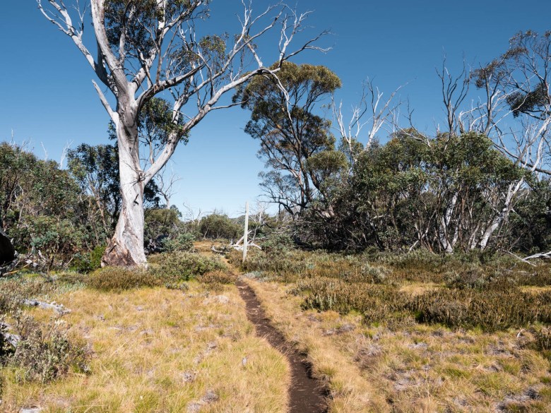
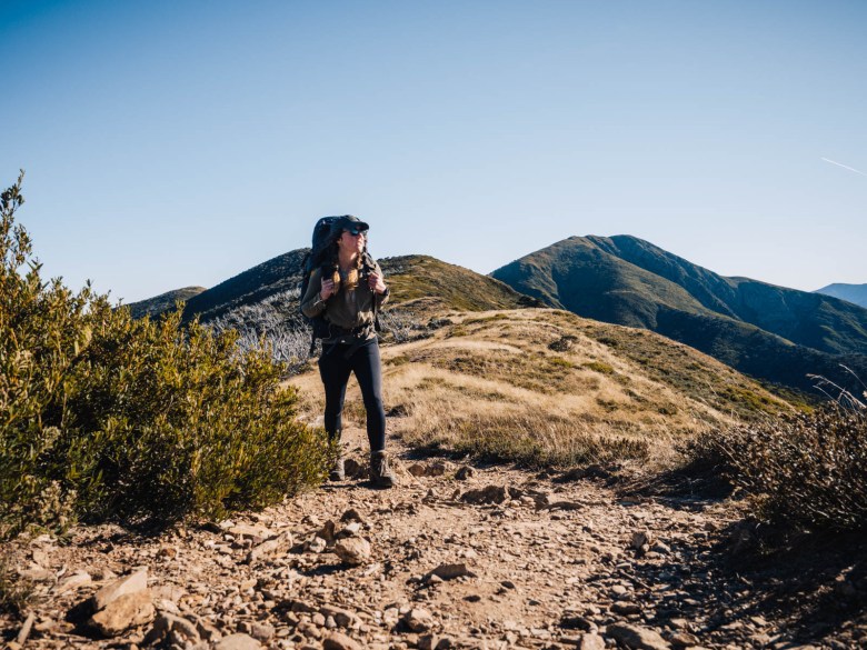
There were quite a few cars parked on the side of the road at the trailhead. I thought it was going to be a busy night, but it turned out that most people were returning after an overnight hike the night before. The Razorback trail was as spectacular as I’d imagined, following the ridgeline all the way to Federation Hut.

The 9.5km trail from Diamantina Hut to the Feathertop-Federation Hut junction was undulating for the most part, up and over the ridgeline on a very well-worn trail. You could see the Aussie alps rolling in all directions, as the trail was above the treeline for most of the day.
Despite its daunting name, it wasn’t an overly difficult trail. The only section that stands out in my mind is a short but decent hill climb for about 1km, which began around 5.5km along from Diamantina Hut. But from thereafter, it just rambled along for the last couple of kilometres to the major junction.
As I approached the junction, Federation Hut came into view down to my left and Mt Feathertop rose to my right in all its beauty. I turned down to camp first, as I planned to head up to the summit later on to catch the sunset.

There was only one other guy camping at Federation Hut when I arrived. I picked a nice spot just off the trail before the hut. From my tent, I could look out over the Razorback from where I’d come that day. I made myself some early dinner as I was pretty hungry and I knew I’d be coming back late after sunset.
Just before I was getting ready to head up for the summit hike, another solo hiker rolled into camp and decided to come with me to watch the sunset. We both headed off to do the 1.8km climb to the top of Mt Feathertop.
The sun was dipping lower and the golden glow across the alps was already magnificent. We sweated it out as we climbed over 200m in elevation in the short distance to the summit. I’d already been to the top of Feathertop before, but to see the incredible colours of the sky at sunset made it seem so much more impressive.
We watched the sunset on a clear and still evening and then walked back down with our head torches showing the way. I climbed into my tent to go to bed and the wind suddenly decided to pick up. It was certainly not as cold as I’d expected, but the wind did keep me awake a little overnight.
There were only three small tents including my own that night at Federation Hut, all three of us solo hikers. How’s that for a change!

Day 2: Federation Hut to Dibbins Hut via Diamantina Spur
Distance: 12.3km | Time: 4.5 hours | Elevation gained: 517m
I contemplated heading up to Feathertop again for sunrise, but that didn’t happen of course. Instead, I got up a little late and packed my gear slowly before beginning the next section of the hike. I headed back along the Razorback for 1.4km and then turned off to the left onto the Diamantina Spur track.
I’d read that this track was extremely challenging and a steep descent. It was immediately obvious that it was much less used than the Razorback with the bushes sometimes overgrown onto the track. Still, by concentrating on the ground it was still relatively easy to follow.
After around 450m there was a small wild camping area with no facilities, which I’m assuming people use when Federation Hut is too busy. Just 200m further down the track, the expected descent began. The trail dropped steeply for 1km and then flatted off again as it followed the ridge of the spur.
Another few hundred metres passed on a rocky and challenging track and then the trail dipped over the edge and dramatically descended down 1.8km to the bottom of the gully. This last 1.8km was slow going, as it descended an incredible 450 vertical metres in just that short distance. It was very rocky and I had to use a hiking pole to stop momentum from dragging me downwards too fast.
The only people I saw for the whole day was a couple coming up this section, and I really don’t know what would be worse, going up or coming down!

My feet and knees were glad when I finally hit the West Kiewa Logging Road. I turned right onto the road and then filled up my water bottles from the river before continuing on (I had carried enough from Hotham until this point). My pace was much quicker along the wide 4WD track.
I passed the turnoff to Blairs Hut to my left, which was just off the road a few hundred metres away. I continued on the logging road to the Red Robbin Mine Battery and intersection. There was still a lot of old mining equipment lying around there, which was interesting to check out. I was completely drained of energy and so I stopped to have something to eat before pushing onto Dibbins Hut.
It was only 2.2km to the campground at Dibbins, but it was mostly uphill. The trail was pretty good for this section though and easy to follow all the way to the intersection with the Falls to Hotham Alpine Crossing.
I came across the official camping platforms first and then the trail continued to where there was more flat ground right by the creek to camp. The hut itself was a further couple of hundred metres away. I picked a nice spot by the water and relaxed for the afternoon until nightfall.

Day 3: Dibbins Hut to Hotham via Swindlers Spur
Distance: 9.5km | Time: 3 hours | Elevation gained: 608m
I left the campground at around 9.30am on the last day of this overnight hike at Hotham and passed the old Dibbins Hut to begin the climb up Swindlers Spur. I knew that it was going to be a bit of a climb but the ascent really knocked the wind out of me. The climb was around 1.4km and gained 320m in elevation. I was completely covered in sweat by the time the trail finally began to flatten out.
The final 2.5km was relatively easy going along the plains, which offered beautiful views across the alps to my left. It was an incredible day, even perhaps too warm, with the cool morning dew having already completely evaporated from the ground.
As soon as I got to Derrick Hut I stopped to have a snack and a drink. I met two young girls who were doing the Falls to Hotham Alpine Crossing, so we had a nice chat during our shared break. I moved on soon enough though for the home stretch back to Hotham.
The last 4km to Mt Loch Carpark undulated along. First it climbed to the top of the ridge from where the Hotham Alpine Resort came into view, then it followed the ridge until it met up with the Machinery Spur track. The last couple of kilometres along this rocky, wide road seemed a little endless. It wound around and up and down until finally coming into the carpark on the side of the Great Alpine Road. The views back across to Mt Feathertop were superb and a nice reminder that you can certainly cover a lot of ground in just 3 days.
As my car was back at Hotham Heights, I had to walk another 900m back along the side of the road to my van (which was safe and sound). It had been such a great 3 days, with absolutely perfect weather. It was definitely the ideal first overnight hike at Hotham for me and I’m already beginning to plan my next one.

Alternative route options
There are so many trails out in this part of the Alpine National Park that it’s possible to make your own version of this hike.
If you only have one night, then you could take the Razorback to Federation Hut, and then head down Diamantina Spur to the West Kiewa Logging Road. You can then follow this road all the way back up to Machinery Spur track which leads back to Mt Loch car park at Hotham. This is nice alternative to an out and back overnight hike along the Razorback, which is a very popular route.
You could also make it a one way hike, by connecting up with the Falls to Hotham Alpine Crossing at Dibbins Hut and heading over to Falls Creek. This would make it a three night hike, including a night at Federation Hut.
If you decide to do this hike as I’ve described you can also camp at alternative huts if you prefer. Instead of spending the second night at Dibbins, you could stop earlier in the day at Blairs Hut or make it a longer day and camp at Derrick Hut. The options are endless!

Essential information for a multi-day hike at Hotham
If you’re planning to do this overnight hike at Hotham, then here’s some more practical and detailed information including what gear to take and water sources on the way.
Campsites
The campgrounds on this hike are at two of the most popular huts in the Hotham Alpine Resort area: Federation Hut and Dibbins Hut. The huts themselves are only to be used in extreme weather conditions, so you must bring a tent to sleep in.
Both places offer plenty of flat ground and there are no designated tent areas so you can pitch wherever you feel like it. They both have drop toilets as well.
The only exception to this is Dibbins Hut. There are tent platforms available but these must be booked in advance at Parks Vic website. They charge $16.80 per site. Otherwise, there are more camping areas around the toilet near the river where you can practically pitch anywhere.
You can technically camp anywhere on the track as well and I passed a few places where it was obvious that people had wild camped. However, keeping to the designated camping areas around the huts reduces overall human impact on the environment, so it’s better to try and use them as much as possible.

Safety
This overnight hike is a very safe option in the Alpine National Park. The trails are mostly well used, especially the Razorback and from Dibbins back to Hotham. The two campgrounds are also frequently used and you’ll likely find other people camping with you.
Serious dangers mainly come in the form of injury or snakes. Make sure that you carry a first aid kit, including a snake bite bandage, in case of emergency.
It’s not uncommon to see snakes in this area, I had seen one at Federation Hut on a previous hike there and other people reported seeing one just before Dibbins Hut.
Essential gear
While I could list everything I packed for this hike, I’ll just list my essential gear here. The weather can be unpredictable up in the Alpine region, so you need to be prepared for all four seasons in one day. Here’s what I couldn’t have done without:
Sleeping bag | You’ll want a good sleeping bag for the High Country, one that will keep you warm no matter the temperature and be lightweight enough to pack easily in your backpack. Sea to Summit is one of the best brands on the market and you can’t go wrong with their Spark -9 degree bag.
Backpack | A 65L pack is usually a good option for multi-day hikes, especially in the Alpine region when you’re going to be carrying warm gear.
Hiking boots | I’m a bit old fashioned when it comes to my footwear and I can’t hike without my hi-cut boots. I’ve been wearing Keen Targhee boots for a couple of years and I’m super happy with them on all adventures.
PLB | Any hiker, especially a solo hiker, should carry a Personal Location Beacon. For the cost, these small devices can save your life anywhere, anytime. If you don’t want to buy one, you can hire one from any Macpac store, find out more here.
Power bank | I rely on my phone (maybe too much) while I’m hiking. From Maps.Me to recording videos to listening to music, I can recommend the BioLite power bank which will easily last days off the grid.
Tent | Try to keep your tent below 2kg as this can quickly become your heaviest piece of gear. I currently have the Big Agnes Copperspur 2-person tent, and it’s been my go-to for all my alpine hiking adventures.
Down jacket | You should be prepared for any weather on alpine adventures, so a down jacket is a must to ensure you keep warm. This Patagonia Nano Down is lightweight, warm and water repellent, so it’s perfect for the High Country.
Food and water access
As with most overnight hikes, you’ll have to be fully self sufficient when it comes to your food and water. You’ll have to carry your own food for the entire trail, which, in this case, is just three days so it’s not too bad. There is a basic shop at Hotham Heights village, although I wouldn’t rely on it in the Green Season. You can do food shopping at Bright, if you need to pick up some supplies before you head to Hotham.
Water is another situation. There are no water tanks on the trail and so you need to be able to carry extra water and refill from the natural springs on the trail. You will need to carry a water filter or be prepared to purify some other way. I used my LifeStraw and also boiled water, and found the water good to drink.
The good news is that there are reliable water sources on this overnight hike at Hotham in the form of the Kiewa River and Cobrunga River. These two streams have water all year round. You can refill from the Kiewa River along the West Kiewa Logging Road or from the Cobrunga River which runs right through Dibbins Hut campground.
This means that you can easily pick up water on the second and third day. However, for the first night at Federation Hut I carried enough water to get me through 24 hours until I met up with the Kiewa River on day 2. This meant carrying 5 litres of water from the start, which was heavy!
The alternative to this is hiking to the water sources from Federation Hut, which are quite a bit from the campground. You can find water 1.2km down the Bungalow Spur Track with a spring marked by a small sign, or from the North West Spur Track, which is about 1.3km from Federation Hut. You can find both these water sources marked on Maps.Me.
Read next: How to Plan Your Food for Hiking

Trail navigation
Trail navigation and track conditions on this hike changed quite a bit from one section to the next. Overall, I would say that you can’t really get lost as long as you kept to the tracks. However, there’s not a whole lot in terms of track markings, but there are signposts at all junctions (although distances are not always accurate on them).
The Razorback trail is pretty straightforward and takes you all the way to Federation Hut and Mt Feathertop without any concerns. This is the most well worn and used track of the entire hike, so it’s a nice easy day on the first day.
The Diamantina Spur track from Razorback down to the West Kiewa Logging Road is more like a goat track that is a little overgrown in places. However, if you pay enough attention, you will be able to make out the faint but used trail as you go.
The logging road is like a 4WD track so there are no problems there. When you leave that road behind and hit the Dungey Track to Dibbins Hut, it’s much skinnier again but well-worn and easy to follow.
The Swindlers Spur going up to Derrick Hut is steep but well worn and obvious, although some of the bushes had overgrown a little. From Derrick Hut, it’s an easy trail above the treeline back to Machinery Spur Track and Hotham.
Don’t forget to download Maps.Me or something similar so you can double check where you’re going. The trails are all marked on there. Otherwise, you can find maps and PDF brochures here.

Cost of an overnight hike at Hotham
Hiking in the Alpine National Park in Victoria is free. There are no park fees, camping fees or car parking costs involved, which is pretty bloody good if you think about it.
The huts and camping areas are also free to use, with basic drop toilets available. The only cost is for camping on the platforms at Cope Hut and Dibbins Hut for those doing the Falls to Hotham Alpine Crossing. However, for this overnight hike at Hotham via Federation Hut and Dibbins Hut, there are no fees. Yay.
Nearby Mt Hotham hikes
If you’re thinking of doing other hikes in the Hotham area, you can try the following:
Falls to Hotham Alpine Crossing
This two night, three day hike has become one of Australia’s most well-known multiday hikes. The 37km one way hike links Falls Creek and Hotham Alpine Resorts using the Australian Alps Walking Track. It’s a popular trail with two campgrounds offering platforms and toilets.
Check out my guide to the Falls to Hotham Alpine Crossing here.
Three Day Hike to the Fainters via Tawonga Huts from Hotham,
If you want to head over towards Falls Creek and the Bogong High Plains, I can highly recommend hiking to Tawonga Huts and the Fainters. This uses part of the Falls to Hotham Alpine Crossing and makes for a nice side trip over 3-4 days.
Check out my guide to the Fainters from Hotham here.
Hotham Huts Walk (day hike)
If you’re looking for a decent day hike at Hotham, I can recommend the Three Huts Walk. This takes in three of the alpine resort’s historic huts including Derrick, Spargos and Silver Brumby. It’s a long almost-20km hike but is worthwhile if you only have a day to explore the area.
Check out my track notes from the Huts Walk here.
Pin this post


[…] hikes while in Falls Creek and Hotham. First, I did the Dibbins Hut section near Hotham while doing this three day hike via Mount Feathertop and then, I did the Cope Hut section when hiking a three day loop around Falls Creek. The thing […]
[…] Country (phew!). This time I threw myself into my first multi-day hike in the Aussie Alps, with a three-day hike at Hotham. The rugged terrain challenged me as I’d expected, and I realised that this is exactly where I […]
Did anyone do this recently? I heard the loop was overgrown and hard to navigate. Hoping this is no longer the case.
Hi, the only section of this loop that would likely be overgrown is the Diamantina Spur. While it’s often a little scrubby and rough going, it’s still doable. I would make sure you have a GPS device or app, if needed (even a basic free one like Maps.Me), but generally the trail is still visible although often narrow. I was there last summer. Hope that helps.
Hi Elisha,
I just completed this 3-day walk and another 4-day one from Pretty Valley Falls Creek incorporating other walks you posted about (including a side trip up Mt Jaithmathang) from March 17th-23rd . The Diamantina Spur trail was clear and easy to follow, though it was quite steep and long, but I just took it slowly. Had an amazing time on both walks with some spectacular views and variety of landscapes & flora. The only issue was 3 school groups showed up to Cope Hut the night I was camping there, so ended up having to find a different spot away from them twice :D. Thanks a lot for all the detailed info about the walks & water sources etc – it really came in handy and made my experience a lot richer!
Hey Jamie, sounds like an amazing few days! So glad my guides helped you out. Haha catching up to school groups is common this time of year, bit unlucky there!
[…] Read more: Guide to the Three Day Loop Hike at Hotham via Mt Feathertop […]