
After having spent most of my time in the Alpine National Park around Mount Hotham, I finally decided to head to Falls Creek to explore further. As the other major ski resort in Victoria, Falls Creek is a popular place to visit in winter. However, it equally offers some great hiking trails across the Bogong High Plains in the warmer months.
I was surprised to find that it’s quite different to the Hotham area. While Hotham is characterised by rolling ridgelines and dramatic valleys, Falls Creek sits nicely on the High Plains, with misty snow gums and herds of wild brumbies roaming the fields.
I decided to make a three day loop hike at Falls Creek. The much more popular Falls to Hotham Alpine Crossing is a one way trail, which makes it difficult for us solo hikers. So instead, I had a look at a map and decided to incorporate Cope Hut, Mount Jaithmathang and Tawonga Huts into a loop.
This is my guide to completing this multi-day hike, which is a fantastic opportunity to explore the Falls Creek area.
Disclaimer: This post contains affiliate links which means I get a commission if you buy a product through my link at no extra cost to you. By doing so, I can keep this blog going and continue to create helpful guides for you. Read more: Privacy Policy
About the Hike
This loop hike around Falls Creek includes the first half of the Falls to Hotham Alpine Crossing, using the Australian Alps Walking Track. Then, the second part of the hike takes you to Tawonga Huts, with a side trip to Mount Jaithmathang. Mount Jaithmathang stands at 1852 metres high, offering incredible panoramic views across the area.
I planned to hike the loop this way, which is clockwise, starting on the AAWT to Cope Hut for the first night and then spending the second night at Tawonga Huts. However, I had a couple of friends who happened to be in Falls Creek and wanted to join me for the Mount Jaithmathang hike, so I ended up doing the loop in reverse/counterclockwise.
This meant my last day was very long to get back to my car, which was fine, but I would recommend not following what I did. If you do the loop the right way (clockwise), it will mean more evenly spread kilometres across the three days. Either way, you can make this loop hike work for you depending on what you prefer and where you park your car.

Getting There and Away
From Melbourne: Falls Creek is 385 kilometres away from Melbourne or around 5 hours of driving.
The nearest town is Mount Beauty, which is a small mountain town sitting in the Kiewa Valley, and is just 30km away from Falls Creek. Otherwise, Bright is a larger town and only 32 km away from Mount Beauty.
Accommodation nearby
If you want to stay somewhere nearby the night before starting the hike, check out some of my recommendations:
Kiewa Country Cottages || Just outside of Mount Beauty, they have two bedroom, self contained cottages set amongst a pretty garden. There’s an outdoor pool and fireplace to relax before or after your long hike. Check availability here.
No. 43 Loft || Located on the highway just before Mount Beauty, this loft accommodation is a cosy spot for a couple or solo hiker. The modern apartment has a kitchenette, private bathroom and a balcony with mountain views. Check availability here.
The Park Mount Beauty || This is the only caravan park in Mount Beauty. It’s a beautiful spot right on the river with plenty of green grass. They have powered and unpowered camping, as well as cabins. Check it out here.
if you prefer camping, you can also camp at Pretty Valley Campground up at Falls Creek. This is a really convenient place as it’s where the trail to Tawonga Huts and Mt Jaithmathang begins. I stayed here the night after I finished the hike and it’s also where I parked my van for the three days during this hike. There’s a drop toilet, but no other facilities. It’s free to camp here.

Parking Options
There are two places to leave your car for this hike, depending on which way you choose to do the loop. The two parking options are: Trailhead for the Falls to Hotham Alpine Crossing (Heathy Spur)/Roper Lookout Walk (on Bogong High Plains Road near Falls Creek Village) or Pretty Valley Pondage (at the end of Pretty Valley Road – unsealed but 2WD accessible, around 7.5km from Falls Creek Village).
If you do the loop as I recommend (clockwise), which is Cope Hut on the first night and then Tawonga Huts on the second, it makes sense to leave your car at the trailhead for the Falls to Hotham Crossing in Falls Creek. This makes the three days quite even in terms of kilometres.
Instead, I left my van at Pretty Valley Pondage and hiked to Tawonga Huts and Mount Jaithmathang on the first day with my friends. This meant when I stayed at Cope Hut on the second night, I had to walk all the way into Falls Creek following the AAWT and then keep walking along the dirt road back to my van.
If you can car shuffle with a friend, it’s even better, because you could then skip the road walking section between the Falls to Hotham Crossing Trailhead and Pretty Valley Pondage completely.

Three Day Hike at Falls Creek
I’m going to detail the hike as I did it, which was counter clockwise. It was such a great three days exploring the Bogong High Plains, with the added bonus of having some friends join for the first night. My trail notes here should help describe what it was like.
Otherwise, as I’ve mentioned above, I’d recommend reversing what I did and parking at the Falls to Hotham Crossing Trailhead in Falls Creek instead and doing the hike in a clockwise direction. Either way, it’s a great long weekend of hiking!

Day 1: Pretty Valley Pondage to Mount Jaithmathang via Tawonga Huts
Distance: 7.7 km | Time: 2.5 hours | Total ascent: 377 m
I met my friends at Pretty Valley Pondage at the end of Pretty Valley Road. We parked both our vans there and then hit the trail through the gates straight ahead.
We followed the Fainter Firetrail which is a well worn trail and popular mountain biking route at Falls Creek. It was only 4km to get to Tawonga Huts. It headed uphill at first for a steady but gradual climb and then started to descend towards the huts. After 3km we passed the turn off for the skinny trail connecting to the AAWT (which I would take the next day).
We continued on the Fainter Firetrail until the Tawonga Huts historic area. There were a couple of people camping there already. We poked around the huts a bit but then continued up to Mount Jaithmathang.

From Tawonga Huts, the Fainter Firetrail continues towards the Fainters. Instead, you’ll see a small sign indicating to turn left towards Mount Jaithmathang.
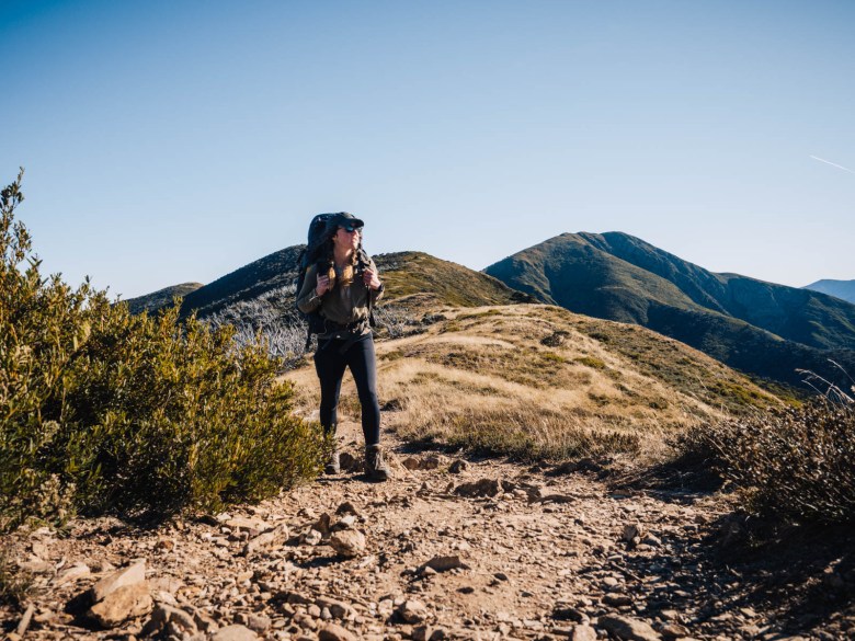
It’s only 2km to reach the top of the mountain. It’s a skinny track that climbs steadily through the alpine landscape to 1852 metres above sea level. The panoramic view from the top of Mount Jaithmathang is worth the side trip. We could see across to Mount Feathertop, Mount Bogong and even Mount Buffalo in the distance.

While originally I had planned to head back down and camp at the huts, my friends were keen to wild camp closer to the summit. So, after spending plenty of time enjoying the view and eating lunch at Mount Jaithmathang, we headed back down the same way.
We had noticed about half way up from Tawonga Huts that there was a nice flat saddle which seemed like a pretty good spot to pitch a tent. So we walked a kilometre back down the trail and scoped out our spots for the night. It had thick alpine grass, which made for soft but dewy padding for our sleeping mats.
We chatted all afternoon and went exploring a bit at sunset to admire the changing colours of the sky against the rolling ridgelines of the Alpine National Park.
Want to extend this hike? Head out to The Fainters from Tawonga Huts. Read more here.

Day 2: Mount Jaithmathang to Cope Hut
Distance: 12 km | Time: 3 hours | Total ascent: 232 m
The next morning the landscape was covered in cloud, but it slowly lifted as we packed our tents and backpacks up. Together we headed back the same way down to Tawonga Huts and then back along the Fainter Firetrail towards Pretty Valley.
After less than a kilometre from Tawonga Huts, we came to the side trail on our right, which was the connecting track to the AAWT. I said goodbye to my friends who were heading back out to their van at Pretty Valley and turned right onto this skinny trail.

It climbed a little and then crossed open plains as it headed towards Pole 333. Pole 333 is a major crossroads of four trails in the alpine region and a well-known intersection for cross country skiing and remote hiking. This pole connects Tawonga Huts with Cope Hut in the Falls Creek area, but it also has two major trails heading over to the Hotham area, the AAWT to Dibbins Hut and the Westons Spur Track towards Mount Feathertop.
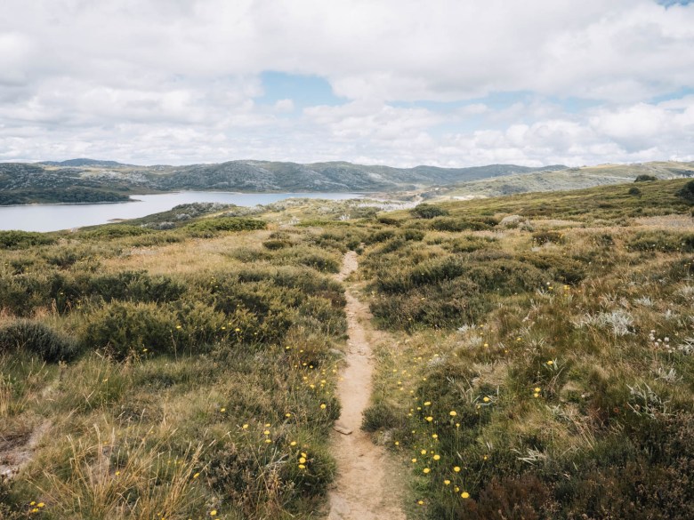
I continued straight ahead on the Australian Alps Walking Track (AAWT) towards Cope Hut. The trail from here is beautiful and relatively easy for 4.5 km to Cope Saddle Hut. It crossed the stunning Bogong High Plains, which were incredibly moody with low hanging clouds and sunlight trying to stream through.

The trail started to dip down towards Cope Saddle Hut, which is located on the dirt road known as Pretty Valley Track (which leads back up to the Pondage if you need to exit the hike early). There was a school group having lunch there and I stopped to talk to the guides.
I crossed over the aqueduct and continued on the AAWT towards my destination for the day at Cope Hut. It was only another 3.7km so I was in no hurry.
The trail had a gradual ascent for most of these last few kilometres, but nothing too difficult. It followed a well-worn track until it crossed over the Wallace Hut Walking Track (make sure you don’t take the Wallace Hut Track by mistake).

Not long after that, the AAWT crosses over a stream on a bridge, which is a perfect spot to fill up water if you need for the second night. From there, it’s just 1.6km to the Bogong High Plains Road. You have to cross the road here and then head down to Cope Hut which is just beyond the small carpark. The campground is up behind the toilet on the edge of the plateau.
I had a great spot underneath the snow gums looking out across the valley below. The sunset and sunrise views from my tent were stunning and it’s certainly one of the best campsites in the area.

Day 3: Cope Hut to Falls Creek and Back to Pretty Valley Pondage
Distance: 24 km | Time: 6 hours | Total ascent: 369 m
On my last day of my hike at Falls Creek, I knew I had a very long trail ahead. I continued following the AAWT, which is also technically the first day of the Falls to Hotham Alpine Crossing, towards Falls Creek.
From Cope Hut, you have to continue down the dirt road away from the Bogong High Plains Road. Then turn left onto the Langford West Aqueduct Road. For the next nearly 7km, you simply follow the aqueduct road, which is flat and easy. It does offer some nice views though initially off to the right.
After the 7km, you’ll see an old bridge crossing the aqueduct on your left (see image below). You should take this trail which climbs steadily up the hill in front of you for around 2km. It was a decent climb and on a skinny trail, but it was still easy to follow.

The trail then crosses over the Big River Firetrail and continues around until you see the turnoff for the Heathy Spur Track on your left. The Heathy Spur Track takes you back into Falls Creek and to the Trailhead Carpark for the Falls to Hotham Alpine Crossing. The 5km trail began with a slight incline, before flattening out and then descending to the carpark.
I’d covered 15km already that morning, so I stopped to have a break in the carpark, which is on the shore of the Rocky Valley Dam. From here, I knew it was just going to be road walking all the way back to my van at Pretty Valley.
For the next 8.5km I walked back along the Bogong High Plains Road to Mount McKay Road, then followed that dirt road all the way to Pretty Valley Pondage. I had forgotten that a lot of it is uphill, so I was pretty tired when I finally got back to my van after a long day!
Essential Information for a Multi-day Hike at Falls Creek
For all the practical things you need to know about a hike at Falls Creek:
Campsites for This Loop Hike
The two campgrounds I used for this hike are very popular hike-in campgrounds in the Alpine National Park. They’re situated next to historic huts and provide a drop toilet for campers.
Cope Hut: This is the first campsite on the Falls to Hotham Alpine Crossing. There are tent platforms (which you must book and pay for) or plenty of flat grassy spots underneath the snow gums for camping. There is a drop toilet and a water tank (empty when I was there). This old historic hut is easily accessible for day trippers off the Bogong High Plains Road as well.
Tawonga Huts: Located on the Fainter Fire Trail next to a mountain stream, the huts were first established by John Ryder in the 1880s. It’s a really pretty spot to camp, with plenty of space and a drop toilet. You could collect water from the nearby stream if you needed to.
Note: We actually chose to wild camp on a flat saddle on the slopes of Mount Jaithmathang because the weather was perfect. There were no facilities there and most people camp at Tawonga Huts instead.
There are very few alternative camping options on this loop. If you really wanted to you could camp at Cope Saddle Hut, which is between Tawonga Huts and Cope Hut on the AAWT. However, it’s not really an appealing spot compared to the ones I’ve recommended.

Safety and Navigation
This hike is a pretty safe option in the alpine region. The trails are well used, so it’s unlikely you’ll get lost. Most of the intersections have major signs, however, some of the obscure intersections can be a little confusing. I’d recommend having something like Maps.Me downloaded on your phone so you can double check you’re on the right track.
Serious dangers mainly come in the form of injury or snakes. Make sure that you carry a first aid kit, including a snake bite bandage, in case of emergency.

Water Access
There’s little water access along this hike, so I’d recommend carrying ample with you from the first day. However, you can find some streams if you need.
There is a natural stream flowing near Tawonga Huts.
Cope Saddle Hut is also near a little stream if you needed. However, the best water access in the area is between Cope Saddle Hut and Cope Hut. Just 2km from Cope Hut where the trail crosses over a decent stream on a bridge, you can easily get down to fill up your bottles or hydration reservoir from there. This is where I’d recommend getting water.
Otherwise, there is actually a stream down from Cope Hut in the valley below. However, it would be a bit of a trip to get there and back for water. There’s a water tank at the campground at Cope Hut, but it was empty when I was there in February.
Read next: How to Leave No Trace and Be Respectful in the Outdoors

Essential Gear
Sleeping bag | You’ll want a good sleeping bag for the High Country, one that will keep you warm no matter the temperature and be lightweight enough to pack easily in your backpack. Sea to Summit is one of the best brands on the market and you can’t go wrong with their Spark -9 degree bag.
Backpack | A 65L pack is usually a good option for multi-day hikes, especially in the Alpine region when you’re going to be carrying warm gear.
Hiking boots | I’m a bit old fashioned when it comes to my footwear and I can’t hike without my hi-cut boots. I’ve been wearing Keen Targhee boots for a couple of years and I’m super happy with them on all adventures.
PLB | Any hiker, especially a solo hiker, should carry a Personal Location Beacon. For the cost, these small devices can save your life anywhere, anytime. If you don’t want to buy one, you can hire one from any Macpac store, find out more here.
Power bank | I rely on my phone (maybe too much) while I’m hiking. From Maps.Me to recording videos to listening to music, I can recommend the BioLite power bank which will easily last days off the grid.
Tent | Try to keep your tent below 2kg as this can quickly become your heaviest piece of gear. I currently have the Big Agnes Copperspur 2-person tent, and it’s been my go-to for all my alpine hiking adventures.
Down jacket | You should be prepared for any weather on alpine adventures, so a down jacket is a must to ensure you keep warm. This Patagonia Nano Down is lightweight, warm and water repellent, so it’s perfect for the High Country.

Cost of the Hike at Falls Creek
Hiking and camping in the Alpine National Park is mostly free. There are no park fees, camping fees or parking costs. However, if you want to use the platforms at Cope Hut, you should book and pay for those via the Parks Website here.
This is part of the Falls to Hotham Alpine Crossing, and camping on the platforms are charged $17.30 per night. However, there’s plenty of flat space under the snow gums to camp on the ground without paying.
Other Hikes to Do Near Falls Creek
If you’re interested in completing other hikes around the Falls Creek and Hotham area, here are some of my favourites.
Mount Bogong
The highest mountain in Victoria is not far away from Falls Creek. In fact, most people start a hike up Mount Bogong from just outside of Mount Beauty. You can either tackle the steep climb to the summit as a day hike or you could incorporate it into a longer overnight hike if you preferred.
If you’re interested in hiking Mount Bogong, check my guide here.
Three Day Hike at Mount Hotham
Similar to this three day loop around Falls Creek, I had previously made a nice three day loop around Mount Hotham. It includes the second part of the Falls to Hotham Alpine Crossing with a night at Dibbins Hut. But the real highlight is camping at Federation Hut on Mount Feathertop.
Check out my guide to this three day loop hike at Hotham here.
Mount Feathertop
The second highest peak in Victoria, Mount Feathertop is closer to Mount Hotham and the town of Harrietville. This can also be completed either as a day hike or longer overnight hike, like the three day loop I just suggested above.
If you want to hike Mount Feathertop, read my guide to all the trails leading to the summit here.
Pin this post


[…] doing this three day hike via Mount Feathertop and then, I did the Cope Hut section when hiking a three day loop around Falls Creek. The thing about hiking solo is that I usually prefer to make a loop rather than a one way hike […]
[…] then went up to Falls Creek for the first time and completed a three day hike to Mount Jaithmathang and Cope Hut. I finished off the summer with a paid job for Webjet, showcasing my home region of the Yarra […]
[…] visiting Tawonga Huts as part of a three day loop hike at Falls Creek last year, I’d wanted to return to hike out to the Fainters. This twin […]
[…] Read more: Guide to the Three Day Loop Hike Around Falls Creek […]
I love your posts – would love if you could add a map showing the area location and the trail each time