
The Victorian High Country is the best place to head for a weekend switched off from everyday life and immersed in some raw nature. While there are endless corners of the alpine region to explore, Mount Howitt hike, Howitt Plains and Bryce’s Gorge can be combined for a perfect weekend trip in the Alpine National Park.
Mount Howitt presents one of the best panoramic views in the High Country and is undoubtedly an underrated day walk in the region. You can then easily explore Bryce Gorge, which includes two dramatic waterfalls and a historic hut.
Over the summer, we headed for a few days to the High Country to check out these hikes and sights. Even with some pretty moody weather, it was a great trip that would be ideal for an introduction to the alpine region over a weekend. If you’re looking for a short camping trip into the Alpine National Park, keep reading!
Disclaimer: This post contains affiliate links which means I get a commission if you buy a product through my link at no extra cost to you. By doing so, I can keep this blog going and continue to create helpful guides for you. Read more: Privacy Policy
Where is Mount Howitt and Bryce’s Gorge?
Mount Howitt and Bryces Gorge are located in the Wonnangatta-Moroka Area of the Alpine National Park in Victoria. The ridge lines from Mount Howitt across the Howitt Plains to Arbuckle Junction are known as the Snowy Range.
It’s best accessed via Tamboritha Road and Howitt Road, which run north from Licola. Licola is the last settlement before you head into the national park. It’s quite famous in the High Country for being the only off-grid village in Victoria, but you’ll find little activity there with just a general store and caravan park.

How to get there
If you’re planning a road trip to Mount Howitt and Bryces Gorge, then you’ll first want to aim for Heyfield. Heyfield is 200km east of Melbourne and the last major town you’ll come across. From Heyfield, Licola is another 53km north on a sealed road.
Once you reach Licola, you need to take Tamboritha Road which follows Wellington River and then climbs up to Arbuckle Junction. This road becomes a dirt road after crossing the last bridge. On the way you can stop at Bennison Lookout, which looks across to the ridge lines of the High Country to your right.
Arbuckle Junction is 47km from Licola. At this major intersection, you need to turn left onto Howitt Road, with Moroka Road being on the right. Howitt Road then continues all the way across the Howitt Plains, past Bryces Gorge and Howitt Hut to end at Mount Howitt Car Park.
From the Mount Howitt Carpark, the road becomes King Billy Track which descends steeply and is strictly a 4WD track. We headed down to check it out and it was pretty slow going, with a few rough creek crossings.
Road conditions: When we did this trip in January the roads all the way to Mount Howitt Carpark were in good condition and accessible for 2WD vehicles. A lot of people assume (as did we initially) that beyond Licola the Tamboritha Road and Howitt Road would be 4×4 only, but this was not the case. This is great news if you’re hoping to do this trip but don’t have a 4WD. However, road conditions can change year to year, so you may want to find out the latest conditions before leaving. Licola General Store will have up to date information.
When to visit the Alpine National Park
The area sees heavy snowfall during winter and road closures are common. Tamboritha Road is generally closed from just after Bennison Lookout in winter, so you won’t be able to do this trip from May until September, depending on conditions.
You should plan your trip to the alpine area sometime from October until April. However, the best time to go to Mount Howitt is in summer when the weather is at its warmest and you’ll have more stable conditions. You’ll also get to see some wild flowers like we did, which makes it even more pretty.
The thing with the High Country is though that you can never predict what kind of weather you’ll get. We did this trip in mid-January and copped some pretty moody weather, including thick fog, sunshine, overcast skies and rain. You have to be prepared for all conditions all year round and pack accordingly.

A Weekend in the High Country: Mount Howitt Hike and Bryce’s Gorge
Over a wonderful few days in the Alpine National Park, we enjoyed some wild camping amongst the snow gums and a couple of great day hikes to some epic views and sights. This is the trip itinerary we had:
We drove up through Licola to Mount Howitt Carpark on the first day and camped there near the carpark. The following day we did the Mount Howitt hike. Then, we chose to camp at the same spot near the carpark again after the hike, but you could pack up and camp down the road at Bryce Gorge Carpark, if you prefer.
The next day we drove to Bryce Gorge Carpark and did the Bryces Gorge Circuit walk in the morning. If you’re just out for the weekend, you could easily drive home after this walk.
However, we continued our High Country trip across to Moroka Gorge and the Pinnacles and camped at Horseyard Flat for one more night before heading home. If you have three nights, this is a good additional night to add.
I’m going to detail the Mount Howitt Hike and Bryces Gorge Circuit Walk below, as well as, provide more info on the camping options for this trip.

Mount Howitt Hike
- Distance: 14.5 km
- Time: 4 hours
- Total Ascent: 501 metres
- Difficulty: Medium
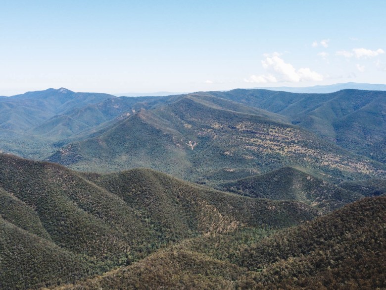
One of the most underrated day hikes in the Alpine National Park, this is an incredible walk up to the top of Mount Howitt at 1742m high. Mount Howitt is part of one of the most stunning sections of the Victorian Alps, along with nearby Mount Buggery, Mount Speculation, The Crosscut Saw, and Mount Cobbler. For many people, these peaks offer one of the best views you can get in the state (although I would argue Mount Feathertop is just as good, if not better!).
The Mount Howitt Hike from Howitt Road Carpark is surprisingly not overly difficult. The first section is just under 5km and takes you to the iconic Vallejo Gantner Hut. From the carpark, it’s fairly flat along an old vehicle track, before it climbs gently to a small hill. From there, it descends to Vallejo Gantner Hut and Macalister Springs.

Vallejo Gantner Hut is a distinct A-frame style backcountry hut that was built in 1971 in memory of a young man who died in a tragic hunting accident. There’s also an incredibly nice toilet block nearby which offers a great view from the loo! This is a popular camping spot, with plenty of room for hikers. There is water in the nearby Macalister Springs generally year round too.
From the hut and camping area, the trail to Mount Howitt descends onto a narrow ridge which is where the views start to appear to your right. It’s an incredible sight looking across to the Crosscut Saw and the deep valley below. The trail then starts to climb upwards and is when you finally emerge from the tree line and onto the snow plains.

After 1.3km from Vallejo Gantner Hut, you’ll make it to the intersection of the Australian Alps Walking Track. The track to your right heads to Mount Speculation via the Crosscut Saw and is a popular overnight or multi-day hike.
You need to take the alps track heading to the left. From there, it’s a long kilometre of climbing up to the summit of Mount Howitt. The panoramic views from the top look across to Mount Buller, Mount Cobbler, Mount Speculation and even across to Mount Buffalo in the distance. The flat top summit is perfect for a snack and a break, but it can get cool quickly up there.
Return the same way back to the Mount Howitt Carpark.
Multi day hike options: Mount Howitt can be combined with a great overnight hike out to Mount Speculation via the Crosscut Saw. Or a longer loop option can be done over 4 days, which is known as the Viking Circuit. This takes you from Mount Speculation to Mount Despair and The Viking before coming back up the Wonnangatta Valley to the Mount Howitt Carpark again. This last option is tough and best reserved for experienced hikers, but the overnight trip to Mount Speculation and back again is a nice option for a weekend.

BUY THIS: Ottie Merino Hiking T-Shirt, Made and Owned in Australia
Bryce’s Gorge Circuit Walk
- Distance: 8 km
- Time: 2.5 hours
- Total Ascent: 209 metres
- Difficulty: Easy-Medium
Bryce’s Gorge is one of the most spectacular gorges in Victoria. It’s largely hidden and you’d never know it was there if you didn’t do this circuit walk to reach it. It sits just beyond Guys Hut and is carved out by the Conglomerate and Pieman creeks which create two of the most impressive waterfalls in the High Country.
We decided to do the circuit clockwise, which is generally recommended. After a kilometre across foggy, snow plains we came to Guys Hut. Guys Hut was built in 1940 by Jack Guy as a shelter for stockmen bringing cattle to the area. It’s a nice spot to check out before continuing on the trail through snow gums and along the top of the gorge.

Without notice, you’ll suddenly come to Conglomerate Falls, the first of the two impressive waterfalls. The dramatic waterfall plunges into the gorge below and is a beautiful spot. While there used to be a track that went around and down to the base of the falls, this is really not recommended. It looked like it would be a very risky climb down and only best left for experienced and fit hikers.
The track then skirts along the edge of the gorge around to Pieman Falls. There is a nice lookout here, but you’ll see where people have walked to the edge of the rocks to get an even closer look, although you’d have to be very careful as it’s a steep drop down.
The circuit then continues away from the gorge and across open snow plains, crossing a couple of creeks before getting back to the car park. It’s a great 8km walk and not overly difficult, with very little incline.

Camping options for this trip
There are some great camping options in this part of the Alpine National Park. We camped at Mount Howitt Carpark, but there are alternatives.
Mount Howitt Carpark: The car park and trailhead for the Mount Howitt Hike made for a nice camping spot, especially when doing the day hike to the summit. Although unofficial, there were quite a few people camping there over the couple of days we stayed. There is a drop toilet near the car park, but otherwise you’ll see the flattened areas where people have set up camp. We were off to the left of the car park, which we thought was the best spot.
Howitt Hut: Just back down Howitt Road, you can camp around the historic Howitt Hut. There is a drop toilet there and some space for camping, although it didn’t seem very appealing to us, especially if you plan on doing the Mount Howitt Hike or Bryces Gorge Circuit Walk.
Bryce Gorge Carpark/Guys Hut Campground: At the car park for the Bryces Gorge Circuit Walk, there are some really nice camping spots. There’s a drop toilet, picnic tables and fire pits for camper’s use. It’s a great spot if you plan on doing the circuit walk.
Tamboritha Road along Wellington River: Just after you leave Licola on the Tamboritha Road, you’ll see plenty of camping spots right along the Wellington River. There are drop toilets in most of the spots and it’s popular during summer with the river to cool off in. It would be a nice place to break up the long drive with an overnight camp before continuing onto Mount Howitt, if you needed.
Remember leave no trace! These campgrounds are free to use and have very limited facilities. You need to respect the environment and remember Leave No Trace principles. Fires are allowed for warmth and cooking, but should be kept to designated pits where possible. Carry all rubbish out with you. Read more about leaving no trace and being respectful in the outdoors.

What to pack for the High Country
If you’re going to be camping and hiking in the Alpine National Park, here’s some essential gear you should take:

Safety in the alpine region
The weather in the alpine region is very unpredictable and can be extremely volatile. You should be prepared for experiencing four seasons in one day, with warm clothing and adequate camping gear similar to what I’ve suggested above.
We did see a copperhead snake on the Bryce Gorge Circuit Hike despite the fact that it was rainy and cool. You should always carry a snake bandage kit while walking in the High Country. Although, if you give the snake plenty of room it will always move away from you.
It’s also important to know that there is not a lot of phone reception around the national park. You will only get reliable reception at Mount Howitt Summit. This means that you should tell someone your plans and carry a PLB for emergencies.
If heading to the alpine region in summer, you should check Vic Emergency before heading out and be aware of any bushfires in the area. You should also check the Parks Vic website for seasonal closures and recent track updates.
Looking for similar trips in the High Country?
If you’re looking for some other trips into the High Country, I’ve got some ideas for you:
- Overnight Hike to Lake Tali Karng from McFarlane Saddle
- Camping at Lake Cobbler and Hiking Mount Cobbler
- The Best Hikes and Views at Mount Buffalo National Park
- A Guide to the Falls to Hotham Alpine Crossing (three day hike)
- 10 Best Day Hikes in the Victorian High Country
Pin this post


I have done these walks many times and am planning to go again in a couple of months and just wanted to check walking distances. I dont think that I have read a better track review. Not only does Elisha cover the essential details of the area, she also gives some very sound advice on what to take. I have driven to Howitt Carpark in a Toyota Celica with 4 passengers and 4 rucksacks on the roofrack. But I still prefer to take at least an AWD just in case of snow. Thanks Elisha for a fantastic track review.
Thank you so much! It really is a great part of the Alpine National Park, glad you thought I did it justice!
[…] to spend most of summer up in the Victorian High Country. It started with a family camping trip to Howitt Plains and Bryce’s Gorge in […]