
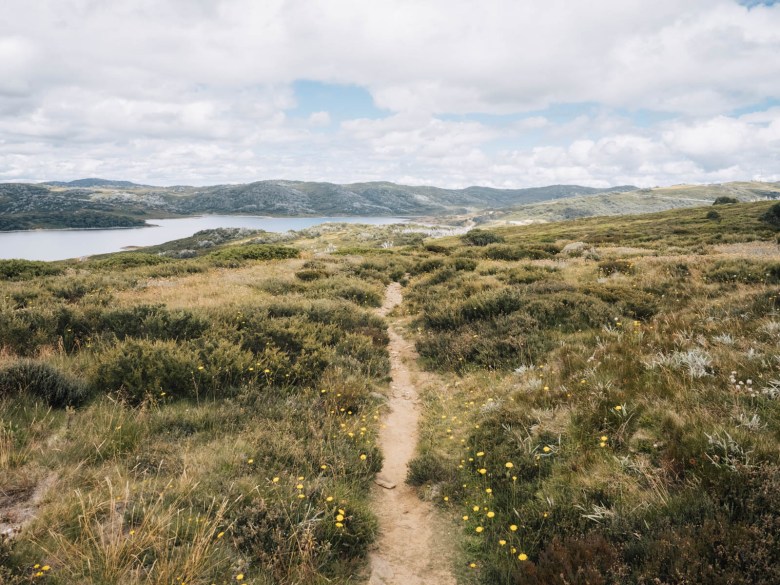
Victoria’s High Country is home to the best hiking trails in the state. Whether climbing one of the highest peaks or tramping through snow gums to historic huts, there’s an endless amount of hiking opportunities in the vast alpine regions of Victoria.
After spending many summers exploring the Australian Alps, I’m putting together this breakdown of the best day hikes in Victoria’s High Country, including Mount Feathertop and Mount Bogong. Providing a chance to escape into the wilderness for a day and admire panoramic views across rolling ridgelines, these trails offer an incredible introduction to alpine hiking.
None of these hikes are a walk in the park, so I’d recommend having some hiking experience and/or a decent level of fitness before undertaking them. But if you’re not ready to tackle an overnight hike in the High Country, then these day hikes will provide the perfect combination of peaks, huts, and challenges all within a day.
Disclaimer: This post contains affiliate links which means I get a commission if you buy a product through my link at no extra cost to you. By doing so, I can keep this blog going and continue to create helpful guides for you. Read more: Privacy Policy
What You Need to Know About Hiking in Victoria’s High Country
The Victorian High Country covers the the various alpine and subalpine areas of eastern Victoria along the Great Dividing Range. Generally, the “High Country” is considered to stretch from Marysville up to the New South Wales border, including the towns of Mansfield, Benalla, Bright, Wangaratta, Beechworth and up to Corryong.
This means it covers some of the best hiking regions in Victoria, including Yarra Ranges National Park, Lake Mountain, Alpine National Park, Mount Buffalo National Park, Mount Buller, Falls Creek, and Mount Hotham. Most of these areas are also Victoria’s main skiing and winter destinations in the colder months. The day hikes I’ve listed below cover all of these areas and are generally the most spectacular and longer of the trails in each region.
The High Country is home to some of the highest mountains in the country, part of the Australian Alps which stretch into New South Wales and Australian Capital Territory. For those with hiking experience, it’s the ultimate place to explore the rugged, mountainous terrain and enjoy panoramic views over expansive wilderness areas.

Safety in Victoria’s High Country
- Phone signal and coverage across the High Country is very limited. You will find phone signal in all towns, ski resorts, and on most high peaks and ridges, but many trails and lower valleys are outside of phone service
- Tell someone where you’re planning to go and for how long, so they can ensure you get back safely or know when to alert authorities if something goes wrong
- Carry the 10 essentials for a day hike, including a Personal Location Beacon, plus all the appropriate gear and clothing you’ll need for your chosen trail, read what to pack for a day hike
- Be prepared for all weather conditions in the mountains and pack for all four seasons in case things change suddenly
- Snakes are common in the High Country, especially in spring and summer. If you see one on the trail, give it plenty of room to move off slowly before continuing and ensure you carry a snake bite bandage in case of emergency
- Other wild animals include wild dogs, brumbies, deer, spiders and birds. Most of the time they will not pose a threat to humans, but ensure you leave wildlife alone and give them plenty of space without obstructing their path
- Fire danger is frequent in the hot summer months. Avoid hiking when temperatures are forecasted to be over 35 and keep an eye on the Vic Emergency app to track any fires nearby
- There are not necessarily way markers or arrows showing you the way on these trails. However, navigation is pretty straight forward as these are all well-worn hikes. You should still have a GPS app such as AllTrails or Maps.Me, and/or a paper map to ensure you know where you are at all times

When to Hike in the Victorian Alpine Region
The hiking season in the High Country generally runs from late spring until early autumn through summer. The best time to go hiking is from November until April, but this highly depends on snowfall over the winter. Even in the middle of summer, you should pack a couple of warm layers as the temperature above the treeline is often less than half of that below in the valleys.
However, the weather in the mountains is highly unpredictable. You must be prepared for a range of conditions, including snow at any time of the year. I’ve hiked in ankle deep snow in the middle of summer on Mount Bogong, so ensure you keep an eye on the weather forecast and pack for all four seasons in case of sudden climate changes.
Wild flower season is in summer. This is when you can often find slopes of the peaks and meadows covered in purple, yellow and white patches of flowers. Generally, January is the peak of wild flower season, but this depends on the weather.

10 Best Day Hikes in the Victorian High Country
If you’re looking for your next challenging day out in the High Country, these hikes are the perfect way to explore the Aussie Alps within a day while getting some incredible views. However, some of these trails are not easily accessible to complete in a single day from Melbourne if you include travelling time. Be prepared to dedicate a whole weekend to completing one of these hikes below.
Add these to your hiking bucket list for Victoria:
👉 I recommend AllTrails for navigation and finding new trails, with offline GPS maps and trail reviews from other hikers. Use code elisha30 for 30% off an AllTrails+ subscription by clicking here!

Mount Stirling Loop Hike
- Location: Mount Stirling near Mount Buller Alpine Village
- Start/finish: Telephone Box Junction, Mount Stirling Alpine Resort
- Distance: 14.5 km
- Time: 4-5 hours
- Difficulty: Moderate
This beautiful day hike is the perfect introduction to the High Country. Not far from Mount Buller, the Mount Stirling Loop takes you up to Mount Stirling summit at 1,747 m and plenty of High Country huts.
It’s surprisingly not overly difficult or challenging, so it makes for a great hike for beginners. The trailhead is Telephone Box Junction (TBJ), which is on a 2WD accessible dirt road. From there, the loop can be done in either direction, although I’d recommend anticlockwise.
Begin by continuing on the Circuit Road for a short bit, before turning off to Baldy Loop and then turning right onto Bluff Spur Trail. This is a steady climb up to Bluff Spur Hut, where you can take a short break before continuing to Mount Stirling Summit.
The 360 degree view from the summit is the real highlight of the hike, as you can soak up almost every peak and ridge of the Victorian Alps, including Mount Buller, Mount Cobbler, Mount Howitt, Mount Buffalo, Mount Feathertop, Mount Speculation, and The Bluff.
From there, head around to GGS Hut before starting to descend past King Spur Hut, Cricket Pitch Shelter, and King Saddle Shelter to the Circuit Road again. From there, you can head back to your car or take a short detour up on the Hut Trail to Razorback Hut, a popular horse riding camp. The trail then continues down to TBJ on the Circuit Road.
For more detailed trail notes: Mount Buller Hikes in the Summer Season

BUY THIS: Ottie Merino Hiking T-Shirt, Made and Owned in Australia
Mount Feathertop via Razorback Trail
- Location: Alpine National Park near Hotham Ski Resort
- Start/finish: Diamantina Hut, Great Alpine Road, Hotham Heights
- Distance: 22 km
- Time: 7-8 hours
- Difficulty: Moderate-Hard
Often considered as one of the best day hikes in Victoria, the Razorback Trail to Mount Feathertop is a must do for all keen hikers across Australia. Following the curves of the ridgeline from Hotham to the summit of Victoria’s second highest mountain, the Razorback Trail offers spectacular views from the start.
The official start of the trail is on the Great Alpine Road at Diamantina Hut. There’s no proper carpark there, so most people park off the side of the road. You’ll be able to see the walking track as it snakes its way along the ridge towards the triangular peak of Mount Feathertop.
It’s not as steep as Mount Bogong for example, as this trail is more undulating, but it can still be challenging due to the long distance. After 9.5km of walking from the trailhead, the Razorback Track comes to a junction. You’ll see a memorial plaque and a beautiful snow gum tree. From here, if you look to the left you’ll be able to see Federation Hut and the Bungalow Spur Track just down below. But to your right, is the final 1.5km to the summit of Mount Feathertop.

This last climb is the steepest of the whole hike, but you’ll be able to appreciate arguably the best view in the Victorian High Country. The summit is a nice spot to sit for a break or you’ll find some shade back at the junction under the snow gums.
If you have the opportunity to car shuffle with a friend, then I recommend taking an alternative return option. After hiking along the Razorback to the summit, you can then take the Bungalow Spur Track down to Harrietville for the descent. However, you’ll need to have two cars, one at each of the trailheads: Diamantina Hut and Bungalow Spur Trailhead.
For a lesser known day hike, you could even do the Northwest Spur via Tom Kneen Track up to Mount Feathertop instead of the popular Razorback. For more information about all of these trails, check out my guide below.
Read more: Mount Feathertop Hike: Different Routes to the Summit

Mount Bogong via Staircase Spur
- Location: Alpine National Park near Mount Beauty
- Start/finish: Mountain Creek Campground outside of Mount Beauty
- Distance: 22 km
- Time: 7-8 hours
- Difficulty: Hard
The ultimate day hike in the Victorian alpine region is the climb up to Mount Bogong. While the peak may not be as striking as Feathertop, Bogong is the state’s highest peak at 1,986 m. The trail is also far steeper than the Razorback, making it a more challenging hike and one that will take you the better part of a whole day.
To ascend Mount Bogong, most people begin from Mountain Creek Campground just outside of Mount Beauty. However, if you have a 4×4, you can actually save a couple of kilometres by parking closer to the Staircase Spur Trailhead.
To make this day hike a loop, I recommend ascending Staircase Spur to the summit and then descending Eskdale Spur, and coming back along Mountain Creek Road. This makes it a 22km effort. The alternative that some people do is go up and back on Staircase Spur, but if you have the stamina for a couple of extra kilometres then take Eskdale Spur coming down instead.
The ascent on Staircase Spur is pretty brutal and consistent from the start. But you’ll be able to appreciate the change in the landscape as you ascend through the forest to the subalpine scrub and then finally above the treeline.

The summit is marked by a large rock cairn, with plenty of flat area to sit and enjoy the view stretching back to Falls Creek, Mount Feathertop, Mount Buffalo and beyond.
Coming back, skip the turnoff for Staircase Spur and take the next left for Eskdale Spur. This will take you back down to Mountain Creek Road on a different spur line, offering beautiful views back towards the summit.
Both spur trails are steep and can be relentless on your knees and legs. Once you hit Mountain Creek Road, there is a shortcut hiking trail that takes you back to the carpark along the river in a more direct route than the road.
Read more detailed trail notes: Mount Bogong Hike, How to Walk to Victoria’s Highest Peak

Three Huts Walk at Hotham
- Location: Mount Hotham Alpine Resort, Alpine National Park
- Start/finish: Mount Loch Carpark or Corral Carpark Mount Hotham
- Distance: 19.5 km
- Time: 6-7 hours
- Difficulty: Moderate-Hard
An underrated day hike in the Victorian High Country that might not take you up to any notable peaks, but it does explore three historic huts of the Hotham area. The Huts Walk is a long loop hike that takes you to Derrick Hut, Spargo’s Hut and Silver Brumby Hut. There’s also the short side trip to Mount Loch summit, which I highly recommend and have included in the total distance above.
While it might not have any overly long ascents like Mount Bogong, there are several steep ascents and descents that make it a tiring and moderately difficult hike to complete.
Starting from the Mount Loch Carpark at Hotham Alpine Resort, follow Machinery Spur Track up to Mount Loch. This offers the best views of the hike, with a spectacular angle of Mount Feathertop and over to Mount Buffalo.
Then, back track a little and head to Derrick Hut via the Australian Alps Walking Track. It’s a short side trip off the loop to actually reach the hut, otherwise you can continue onto Spargo’s Hut.

The trail is a little faint getting to Spargo’s Hut, but as long as you follow the orange snow poles, they’ll lead along the ridge from where you can then find an old mining track which leads to the historic hut.
Spargo’s Hut is located on a nice plateau and is a good spot for lunch, although there’s not much shade around. From there, the trail descends steeply down Golden Point Spur, across Swindler’s Creek and back up to the Cobrunga Ditch Walking Track.
This old trail eventually emerges onto the Davenport Access Track, where you can take the detour to the Silver Brumby Hut, which is 2.8km return trip. Then, it’s a steep climb up the access track to the Great Alpine Road, which you can follow through the main Hotham Alpine Resort area and back to the carpark.
Read more detailed trail notes: Day Hike at Hotham: Huts Walk

Mount Jaithmathang from Pretty Valley
- Location: Falls Creek Alpine Resort, Alpine National Park
- Start/finish: Pretty Valley Pondage, Falls Creek
- Distance: 12.5 km
- Time: 4 hours
- Difficulty: Moderate
Another underrated hike to a peak that most don’t know about, this walk up to Mount Jaithmathang offers some of the best views in the High Country. The trail starts from Pretty Valley Pondage, which is accessed via the dirt but 2WD accessible Pretty Valley Road at Falls Creek Alpine Resort.
You can park near the pondage (past the free camping area), which is a pretty picnic spot amongst snow gums on the edge of the lake. It’s not an overly difficult hike, with the first section to Tawonga Huts along the Fainter Firetrail.
Once you make it to the historic huts, which is a beautiful camping area for those doing an overnight hike in the area, the Fainter Firetrail continues towards the Fainters. Instead, you’ll see a small sign indicating to turn left towards Mount Jaithmathang.
It’s only 2km to reach the top of the mountain peak from there. It’s a skinny track that climbs steadily through the alpine landscape to 1,852 m. The panoramic view from the top of Mount Jaithmathang takes in Mount Feathertop, Mount Bogong and even Mount Buffalo in the distance.
There’s plenty of boulders to sit in the sun and have a picnic with the view, before retracing your steps back to your car. Mount Jaithmathang is also a good side trip for a few multi-day hikes at Falls Creek, more info on these is at the bottom of this post.
Mount Nelse from Falls Creek
- Location: Falls Creek Alpine Resort
- Start/finish: Heathy Spur Carpark
- Distance: 16 km (add 3-4 km if adding Johnstone and Edmondson Huts)
- Time: 4-5 hours
- Difficulty: Moderate
Another peak that acts as a popular side trip to longer multi-day hikes, you can easily summit Mount Nelse in a day from Falls Creek. This day hike is a relatively easy-moderate trail, making it a nice option as an introduction into the High Country or even as a family adventure with kids.
Begin at the Heathy Spur Carpark at Rocky Valley Pondage, which is also the beginning of the popular three day hike known as the Falls to Hotham Alpine Crossing. Follow the well-worn and gentle Heathy Spur Trail for the first 5km until it meets up with the Big River Firetrail.
Then, turn left towards Mount Nelse. Off the fire trail, you have the option for three side trips; the first one on your right is to Johnstons Hut, another on the left will take you to Edmonsons Hut, and the final one on your right is to the summit of Mount Nelse.
If you’re keen for a longer day out, then you can do all three side trips out and back. Otherwise, if you’re not as interested to see High Country Huts and prefer good views, then just head up to the Mount Nelse summit and back which will be about 16km all up (you’ll add another 3-4 km if doing both the huts as well).
From Mount Nelse, you’ll have a good view of Mount Bogong and the whole Falls Creek and Bogong High Plains area.

Mount Howitt Hike
- Location: Howitt Plains in Alpine National Park up from Licola
- Start/finish: Mount Howitt Carpark, Howitt Road
- Distance: 14.5 km
- Time: 4.5 hours
- Difficulty: Moderate
How many times can I say underrated? But Mount Howitt is not as popular as other day hikes around Falls Creek and Hotham, yet I think Mount Howitt has one of the best views in the whole Victorian High Country. Plus, the moderate hike is definitely achievable for many hikers.
The only downside to this hike is the access. It’s a long drive from Melbourne, first to Heyfield and then to Licola. From there, Tamboritha Road follows the Wellington River and becomes a dirt road after crossing the last bridge. It climbs into the Alpine National Park to Arbuckle Junction, where you need to turn left onto Howitt Road and continue past Bryces Gorge and Howitt Hut to Mount Howitt Car Park.
This is generally 2WD accessible, but conditions can change over the course of the season so it’s best to check before heading out. The drive from the city all up can take 5-6 hours, so it’s not really possible to complete this hike and head back all in a day. And the only accommodation near the trailhead is camping; vehicle-based camping is available at Mount Howitt Carpark, Howitt Hut, Bryces Gorge Carpark/Guys Hut Campground or Wellington River Camping along Tamboritha Road.

The first section of the hike is just under 5km and takes you to the iconic Vallejo Gantner Hut. It’s a fairly flat warm up along an old vehicle track, before it climbs gently and descends to Vallejo Gantner Hut and Macalister Springs.
This is a distinct A-frame style backcountry hut that was built in 1971 in memory of a young man who died in a tragic hunting accident. There’s also an incredibly nice toilet block nearby which offers a great view from the loo! This is a popular camping spot, with plenty of room for hikers. There is water in the nearby Macalister Springs generally year round.
The trail to Mount Howitt then descends onto a narrow ridge which is where the views start to appear to your right across the Crosscut Saw. The final climb begins as you emerge from the tree line and onto the snow plains.

You’ll make it to the intersection of the Australian Alps Walking Track. The track to your right heads to Mount Speculation via the Crosscut Saw and is a popular overnight or multi-day hike. Heading to the left will take you to Mount Howitt summit, with a long kilometre of climbing left.
The panoramic views from the top at 1,742 m look across to Mount Buller, Mount Cobbler, Mount Speculation and even across to Mount Buffalo in the distance. The flat top summit is perfect for a snack and a break, but it can get cool quickly up there. Retrace your steps and head back the same way to the carpark.
If you decide to complete this hike on a weekend camping trip to the High Country, there’s another nice day walk to do nearby at Bryce’s Gorge. Read more in my post below.
Read more: Exploring Mount Howitt Hike and Bryce’s Gorge

Mount Cobbler from Lake Cobbler
- Location: Alpine National Park, east of Mansfield
- Start/finish: Lake Cobbler Camping Area
- Distance: 9 km
- Time: 3 hours
- Difficulty: Moderate
A lesser known day hike, mostly because it requires 4×4 access if you want to complete it in a day, but Mount Cobbler is a great half-day adventure in the High Country. To reach the trailhead at Lake Cobbler, you’ll have to get to Whitfield and then take the Rose River Road through Cheshunt to Bennies Camping Area. From there, the road becomes progressively rougher for the next 20km to Lake Cobbler, which is why a 4WD is necessary.
The Mt Cobbler walking track begins from the camping area, with a signposted trail leading off to the left of the hut. The trail is well-worn, so it’s relatively easy to follow through the forest.
It dips down into a gully and over a creek, before the steady climb begins as you make your way above the treeline. After 3km, you’ll find a wild camping area for those doing an overnight hike in the region. From there, take the right trail at the intersection towards the summit.
The rocky exposed summit of Mount Cobbler looms ahead. The trail is harder to follow there across the bare rock, so pick your own way up to the highest point which is across to the left along the ridge. From the lofty 1,628 m peak you’ll be rewarded with a 360-degree view across some of the most wild and remote areas of the Alpine National Park. Return the same way.
Read more: Camping at Lake Cobbler in the High Country

Keppel Hut
- Location: Yarra Ranges National Park near Lake Mountain Alpine Resort
- Start/finish: Lake Mountain Carpark, Lake Mountain Alpine Resort
- Distance: 17 km
- Time: 5 hours
- Difficulty: Moderate
A part of the High Country that is often ignored by hikers, the upper half of the Yarra Ranges National Park covers the ski resort of Lake Mountain. While the hikes are not as spectacular as others on this list, the walk to Keppel Hut offers something different and is also one of the closer options to Melbourne.
The loop to Keppel Hut via Boundary Hut is one of the longest hiking options at Lake Mountain and takes you to the historic huts of the lower alpine area. Keppel Hut can technically be reached by 4WD too, although this depends on road closures.
Begin at the main carpark at Lake Mountain Ski Resort at the top of the mountain. I’d recommend getting a hiking brochure from the office, as their trails can be quite confusing sometimes and it can come in handy.
First, take the Royston Trail, a well-kept and wide track through snow gums as it rises up onto the plateau. Once you get to Triangle Junction, continue straight on the Royston Trail which turns into the Panorama Loop Trail. If you take the loop trail clockwise, you’ll then come to the turn off for the Hut Trail.

This takes you past the turnoff for Boundary Hut ruins, the highest point of the Yarra Ranges National Park, which is worth a quick look. Then, continue to Keppel Hut. This part of the trail is seldom looked after, so it becomes a skinny path through thick vegetation that can be a little overgrown sometimes.
It descends pretty quickly towards the hut. You’ll eventually pop out on the Keppel Hut 4WD Track, where you simply turn right to the hut and picnic area. It’s the perfect spot to relax and have lunch before returning the same way.
After passing Boundary Hut on the Hut Trail, you can choose to take the slightly longer Panorama Loop Trail to the left which leads to the Panorama Lookout over the Australian Alps. Once you join back up with the Royston Trail, you can opt to take the Muster Trail to return to Lake Mountain. This simply varies your return and makes it more of a loop hike.
Read more: Best Lake Mountain Walks to Do This Summer

Baw Baw Three Peaks Hike
- Location: Baw Baw National Park
- Start/finish: Mount Baw Baw Village
- Distance: 15.5 km
- Time: 4.5-5 hours
- Difficulty: Moderate
Easily the best day hike in Baw Baw National Park, this moderate hike takes in three peaks within the park. Starting from Mount Baw Baw Village, you’ll have to find the Summit Trail as it winds its way through snow gums to the summit of Mount Baw Baw (1564m).
Then, continue on the summit trail to the north until you find a trail on your right. Follow this to the junction of the Village Trail and turn right towards Mount Saint Phillack (1556m). After the summit, continue on the Australian Alps Walking Track to Mount Saint Gwinear (1509m).
From that summit, continue walking for approximately 1km until you locate a trail on your left. Follow this trail as it forms a small loop and returns below the Mt St Gwinear summit to the AAWT.
Retrace your steps all the way back to the Village Trail intersection. From there, you can take the right trail which will loop you back around to the Baw Baw Village from a different direction.
These trails are all well-defined and maintained and include a combination of single-track paths, formed boardwalks, and wide gravel paths. Most of the walk takes you through snow gums, fields of wildflowers, and exposed peaks which offer magnificent views into the Victorian Alps. The undulating hike is moderate but likely to be more tiring than you think, so be prepared for several breaks at the summits.
Turn this into an overnight hike: Baw Baw to Mushroom Rocks Overnight Hike

Essential Hiking Gear
Looking for Overnight Hikes in the High Country?
All of the hikes above can be extended into overnight and multi-day hikes. In fact, many of the trails mentioned in this post are part of longer trails that allow you to camp out in the alpine region and enjoy the incredible wilderness areas in a more intimate way.
Check out my guides on these longer multi-day hikes in the High Country:
- Complete Guide to the Falls to Hotham Alpine Crossing
- Three Day Hike at Hotham via Mount Feathertop and Dibbins Hut
- Three Day Loop Hike at Falls Creek: Mount Jaithmathang and Cope Hut
- Guide to the Four-Day Mount Bogong Circuit Hike
- Hiking to The Fainters via Tawonga Huts from Hotham
Pin this post


💙
[…] Read more: 10 Best Day Hikes in the Victorian High Country […]
[…] of the most underrated day hikes in the Alpine National Park, this is an incredible walk up to the top of Mount Howitt at 1742m high. Mount Howitt is part of […]
[…] Read more: 10 Best Day Hikes in the Victorian High Country […]