
One of the best ways to explore Nitmiluk Gorge, or commonly referred to as Katherine Gorge, is on foot. There is an incredible network of trails known as the Southern Walks, which extends as far as Eighth Gorge in Nitmiluk National Park.
While you’ve likely heard of the Jatbula Trail in the same national park, the Southern Walks is rarely talked about. I didn’t know anything about it until I was in Katherine in the middle of the dry season. While I went on to do the Jatbula later on as well, I still think the Southern Walks is severely underrated.
It offers an incredible way to see Nitmiluk Gorge from a different perspective, as well as the chance to swim and camp in secluded places over multiple days. However, I got caught out in an intense heat wave that left me and a handful of other independent hikers battling out there in 40 degree heat. It turned out to be quite a challenging experience, but one that I certainly won’t forget anytime soon.
If you are going to head out on this walk, I’ve detailed all the information you’ll need below. Plus, I’ve included my day by day trail notes to give you an idea of what it was like hiking in the heat.
Disclaimer: This post contains affiliate links which means I get a commission if you buy a product through my link at no extra cost to you. By doing so, I can keep this blog going and continue to create helpful guides for you. Read more: Privacy Policy
When to hike in Nitmiluk National Park
Hiking in Nitmiluk National Park is only recommended between May and September, which is the cool dry season. You can expect stable weather during these months, with clear blue skies, lower humidity and temperatures between 25 and 30 during the day. It’s the perfect time to cool off in the water holes and Katherine River.
October to April is the wetter and hotter season in the Top End. Tropical storms are common, temperatures soar into the 40s and it’s usually very humid. Swimming is also not allowed across most of the national park due to high water levels and flooding.
If you want to know more about the national park and things to do ther: A Complete Guide to Nitmiluk National Park

Permits and camping fees
Walking permits and camping fees are essential for completing an overnight hike in Nitmiluk National Park. Permits can be obtained at Nitmiluk Visitor Centre when you pay your camping fees.
You can pre-book the campsites either in person at the visitor centre or by phone in advance. Camping fees for the Southern Walks is $4 per person per night. There is a limit of 10 people per campground and there’s only three designated campgrounds on the Southern Walks trail network.
You must also attend a pre-departure briefing which are run daily between 7.30am and 1pm and can be done at the same time you pick up your permit and camping fees.
Note: This is a far easier hike to book than the Jatbula Trail, which sells out months in advance. I booked just a couple of days out from departure in August, but you should ideally book a week or so before if you can so you can get your desired itinerary.
Watch my vlog from this hike here!
Campgrounds for the Southern Walks
There are only three designated places to camp out on the Southern Walks network of trails. You must book and pay for them as mentioned above, with a maximum of 10 hikers per spot.
All three campgrounds have basic drop toilets and emergency phones. You also have access to the gorge from Smitt Rock and Eighth Gorge for water, otherwise there are some water tanks available along the Yambi Trail, including at Dunlop Swamp.
Dunlop Swamp
Definitely the least desirable of the three campgrounds, this is just 3km away from Smitt Rock but in a lush, swampy area away from the gorge. The only upside is that there’s plenty of shade and some nice birds to listen to, plus a water tank supplying drinking water.

Smitt Rock
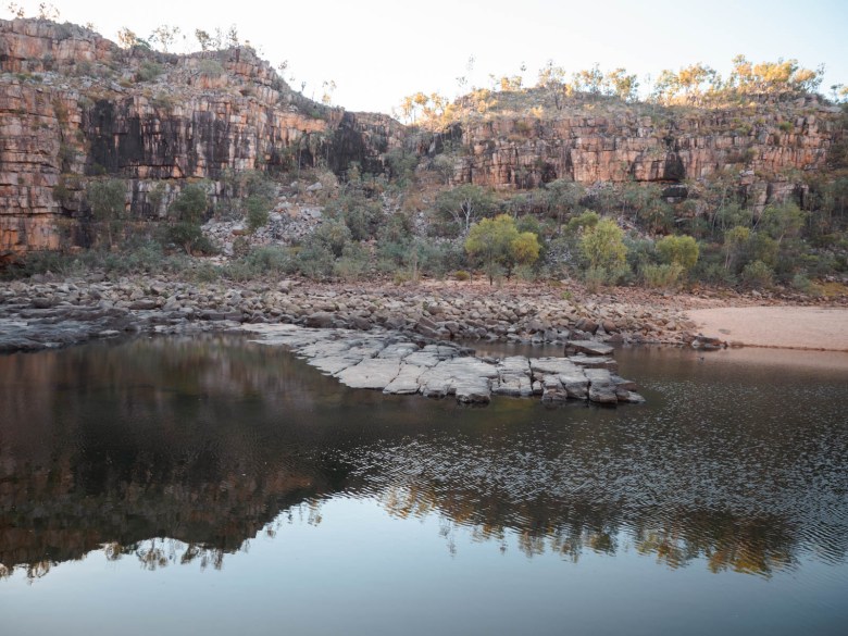
A beautiful spot right on the edge of the escarpment overlooking fifth gorge. There is one tent spot right near the edge which is definitely the best one if you get there first. Otherwise, the camping area is a little disappointing with few nice spots to choose from.
You can walk down to the gorge and swim in the Katherine River from this campground. But, expect a very steep, scramble for around 600m or so down and then to the right to get to the water. Once you reach it, however, it’s a stunning swimming spot in 5th gorge with plenty of sand to laze around on all afternoon.

Eighth Gorge
Arguably the best campsite, this is right on the edge of a billabong and just back from the edge of the escarpment. The camping is on the sand around the billabong, and there is some limited shade. You’ll also find a good lookout spot perched on the edge of the escarpment which is great for watching the sunset.
Otherwise, there is a walking track which continues straight ahead once you arrive in camp (there is an arrow showing the way) that heads down to Katherine River for around 700m. There is a nice little sandy spot on the edge of the water with the huge 8th gorge for swimming.
The toilet is a bit of a hike up from the camping spots, which you’ll pass as you approach the camp.
Southern Walks map

Southern Walk route options
While the map can look confusing at first, there is effectively two main trails you need to be aware of: Waleka Walk and Yambi Walk.
The Waleka Walk is the trail closer to the edge of the Katherine Gorge escarpment. It winds its way up and down, over rocky sections and includes some challenging scrambling spots. It’s definitely the harder option.
The Yambi Walk is the easier walking track. It’s a wider, sandy track which is used by rangers to fill up the water tanks. It’s longer in some sections than the Waleka Walk but is usually much quicker because it’s mostly flat.
There are also a couple of connecting tracks between the Waleka and Yambi, especially at Smitt Rock.
To experience both tracks, a popular itinerary is to take the Waleka Walk to Smitt Rock, then onto Eighth Gorge the next day and then take the Yambi Walk all the way back to the car park for a three day circuit.
Due to the insane heat wave I was caught in during my time out there, I stuck to the Yambi Walk as much as possible. It’s really up to you, but if you pick the Waleka Walk at any point, make sure you leave early in the morning and are fit and capable to handle some scrambling.
Read next: 10 Tips for Your First Overnight Hike
Where to park and how to get there
The hiking trails all start from near the Nitmiluk Visitor Centre, which is around 30km northeast of Katherine. Katherine is a major town in the Top End with all the shops, supplies and accommodation you’ll need before and after your hike. If you’re coming from Darwin, the Nitmiluk Visitor Centre is 340km south of the city on the Stuart Highway.
Parking is available for multiple days in the Nitmiluk Visitor Centre car park. There’s plenty of room there and rangers allow all hikers to leave their cars there. The other option is to leave your car over at the ranger station, which saves you a couple of hundred metres of walking. There are only around 8-10 spots there though, so if it’s full you can simply park in the main area. I used both areas for overnight parking while hiking, and never had a problem at either spot.

Track notes from the Southern Walks
This details my personal experience on the Southern Walks. I had a pretty intense experience, facing 40+ degree heat and suffering mild heat stroke on the first day. While I’m going to be honest with my experience below, don’t let this put you off, just plan accordingly!
Day 1: Nitmiluk Visitor Centre to Smitt Rock
- Distance: 11.5km
- Time: 3.5 hours
- Total ascent: 250m
I picked up my permit and paid my camping fees from the Nitmiluk Vistor Centre at around 7.30am. Originally, I planned to leave for the hike at 8am, until I walked back to my van to find it leaking petrol! I had no phone reception, so decided to drive back towards Katherine.
After numerous phone calls, we agreed that it was likely because I had filled the tank up and the intense heat that had gripped Katherine for the previous few days had caused the fuel to expand. So, I had to drive around Katherine until I used about a quarter of the tank, and it stopped leaking (the joys of driving a 1997 vehicle!). Then I drove back to the visitor centre and didn’t get to leave for the hike until 11am. What a morning!
This severely affected my plans as I’d wanted to start at 8am to tackle the harder Waleka Walk to Smitt Rock Campground. However, as it was already well into the 30s at 11am, I decided to skip the difficult trail and take the Yambi Walk.

The Yambi trail is a wider management track and much flatter than the Waleka. There were a couple of hills in the first few kilometres, but otherwise nothing too strenuous. I made it to Dunlop Swamp to refill my water and was still feeling pretty good.
From there, I had 3km left to reach Smitt Rock. The next 1.4km to the intersection with the Waleka Walk were a bit more challenging, with a couple of rock scrambling sections. From the intersection it was just another 1.6km to Smitt Rock. I finally got to appreciate some views, as the trail skirted along the escarpment.
When I was just 700m from camp, I suddenly hit a wall. My body was overheating and I’d sweat a lot. I dropped my pack and sat in the shade for a bit, while making myself some hydralite (rehydration solution). I gathered the energy to get to camp, which was not overly impressive. There were a few tent spots between rocks and scrub, although you could see the gorge down below from the rocks.

I made sure to eat something and relax before setting up camp. I then worked out that to get down to the water for swimming, you had to scramble down the gorge wall, so I decided to do it in the later afternoon. While it was a tough scramble down, especially as I was feeling dizzy in the heat of the sun, I immediately felt better the moment I throw myself into the water.
I relaxed on the sand and in the water for a while, and met a German lady who came down from Smitt Rock behind me. There were also two girls who were camping on the beach opposite us. They’d canoed up to fifth gorge and I almost felt like asking them to row me back.
I made it back up to Smitt Rock and made some dinner. I was in bed early and slept well until first light.

Day 2: Smitt Rock to Eighth Gorge
- Distance: 10.5km
- Time: 3.5 hours
- Total ascent: 160m
I got up after sunrise and started to pack up my tent. However, I felt a bit dizzy and weak as I gathered all my things. I had to sit down a few times and tried to stomach some food, but had little appetite for much at all. I tried to ignore it but my body was clearly not coping. Once my bag was packed, I lay down on the rocks to try and think about what to do.
The German lady was concerned but I waved her off and said I’d be fine. It was nearly 9am and I realised I would have to make a decision before it got too hot. I figured the smartest thing for me would be to just head back out to the car park and admit defeat, which wasn’t an easy thing for me to swallow.
I picked my pack up and decided to just walk the 3km back the same way I’d come yesterday to Dunlop Swamp. From there, I would have three options. Walk back to the car, keep going to Eighth Gorge as planned or even just stay and camp at Dunlop Swamp if I really wasn’t good.

I made it back to Dunlop Swamp and actually felt a bit better once I started walking. I bumped into two girls at the swamp who were coming from Eighth Gorge. They were Katherine residents and said they’d never experienced this kind of heat in August before. They both said they’d really struggled to make it to Eighth Gorge and had thought about giving up. It certainly made me feel a lot better!
They also told me the 8km along the Yambi trail was pretty easy and the camp at Eighth Gorge was incredibly worth it. I thanked them so much for my newfound confidence and decided to keep pushing on and get to Eighth Gorge.

They were right. The 8km was pretty flat and on an easy, wide track. I filled up all my water carriers at the last tank, so I had 5L in total. I passed another solo girl heading back out and she said, there was a moment she’d thought she was going to die the day before. So far, I’d only met women out there and I thought, look at us girls battling out here!
I walked down into Eighth Gorge and immediately threw my pack on the sand. Absolute paradise! It was a very sandy bank on the edge of a billabong. I lay under the shade for hours, until I gathered enough energy to do the walk down into the gorge. Luckily this was a bit easier than Smitt Rock, and I dunked myself under the water to try and cool my body off.
Once I got back up to camp, the German lady arrived, and we cooked dinner together up on the edge of the escarpment overlooking the gorge. It was such a nice night, but the temperature hardly dropped and I just lay under the inner flyscreen of my tent looking at the stars.

Day 3: Eighth Gorge to Nitmiluk Visitor Centre
- Distance: 16km
- Time: 5 hours
- Total ascent: 200m
I woke up feeling pretty happy that it was the last day of the hike. I got up and packed all my gear by 7.30am. While I wasn’t keen on facing the 16km, I knew it was just all the way back on the easier Yambi trail with multiple water tanks to refill from on the way.
It was already hot by around 9am, and I tried to push at a decent pace to get the kilometres behind me. I was over halfway by 11am but the heat was really starting to kick. The trail was pretty boring, especially as I’d done a lot of it over the last couple of days already.
I passed a group of girls heading out together and they looked so fresh and happy. All I could say was, “Good luck!”. I had a rest at the Butterfly Gorge trail intersection and chatted with some day hikers there. I was starting to tire and wanted to finish this thing quickly.

With 2km to go, there was a long gradual ascent and then finally, the last flat section to the car park. I was walking at a quick pace, but I have to admit I started getting emotional the minute I could see my van. It had been a very challenging three days and I’m not sure you can really understand what it’s like walking out in the exposed heat without having been out there.
I was so relieved to be finished, but also appreciative of the women I met out on the trail. We had all suffered but somehow endured, and these are only lessons that we can draw upon in the future. I don’t regret doing the hike when I did, because I think it was a timely reminder of my vulnerability and humanity. Sometimes we need to face some danger in order to remember it’s important to be prepared and look after yourself.

Essential information about the Southern Walks
Some important things to know if you’re planning on doing this hike yourself.
Safety
The main danger on any hike in the Nitmiluk National Park is the heat. Even if you’re hiking in the dry season, you should be prepared for hot conditions. When I did it in August there was an intense heatwave in Katherine that pushed the temperatures to 40 degrees each day. This is not a joke and you can die from heat stroke, dehydration or heat exhaustion.
While you can’t escape the heat, there are some things you can do to prevent being affected.
- Drink plenty of water (I was drinking around 5L per day!)
- Eat plenty of energy dense foods
- Carry rehydration solution or hydralyte (electrolytes) with you to add to your water
- Start walking early in the morning to avoid the heat of the day (I started walking at sunrise every morning)
- Keep your body temperature down by wetting your hat or shirt when possible and going for a dip in the rivers and swimming holes
- Stay out of the sun as much as possible when you reach camp
- Take frequent breaks during the day
The other couple of dangers include the chance of seeing a King Brown Snake, although populations are almost completely gone now thanks to the cane toad. Wild buffaloes are present in the national park, but rarely spotted.
Read more: How to Survive Hiking in Extreme Heat

What to pack
While I’m not going to list everything to pack here, I’ll detail some of my essentials for a hike like this. I didn’t need a sleeping bag or any warm clothing because of the heat. This made my pack quite light compared to my usual hikes in Victoria!
- Lightweight hiking tent: A high quality tent that requires a bit of an investment, but one that you’ll have for many years.
- Black Diamond Headtorch: This is especially important when getting up before the sunrise to beat the heat.
- 3L Hydration Reservoir: I had capacity to carry 5L which I needed every drop of, so I find a hydration bladder pretty useful.
- Keen hiking boots: Lightweight but durable option, that I’ve used for the past year.
- Sea to Summit microfibre towel: Especially important when you’re going to be swimming!
Want to find out what else I carry on a multiday hike? Complete Overnight Hiking Packing List

Food and water
You’ll need to carry all your food for your intended hike. There are a couple of hiking and camping shops in Katherine which sell dehydrated meals and hiking food.
It’s important to manage your water well on this walk. Along the Yambi Trail, you’ll find five water tanks, which are marked on the walking map. The Waleka Track does not have any water tanks. Smitt Rock and Eighth Gorge campsites don’t have water tanks but you can collect water from the river.
It’s advised to filter the water from the water tanks and the river. I met hikers who had an upset stomach from drinking straight from the river, so carry a LifeStraw or Sawyer Squeeze Filter if you can.
I was drinking 5-6L a day, which was mostly because of the extreme heat I had. But you should always fill up your water when you get a chance out there.
Read next: How to Plan Your Food for Hiking
Navigation
The trails are very well-marked with blue, green and orange arrows on reflective background. They’re colour coded, so blue is Yambi Walk, green is Waleka Walk and orange is other minor trails. They are spaced up to 50m a part, but you can usually see the next one each time you reach one. Otherwise, all intersections are also signposted.
Exploring more of the Top End?
The Top End of the Northern Territory is an incredible place to explore with some stunning national parks. If you’re planning a trip to Katherine and Darwin, check out some of my guides:
- 15 Best Things to Do in Darwin and the Top End in Dry Season
- The Best Swimming Spots and Waterfalls in Litchfield National Park
- A Travel Guide to Kakadu National Park Without a 4WD
- An Essential Guide to Visiting Edith Falls
- 7 Best Markets in Darwin
Pin this post


[…] you might have to face some hot weather on a scheduled hike. Treks like the Jatbula Trail and Southern Walks in Nitmiluk National Park are almost always undertaken in hot weather, simply due to the climate of […]